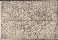
Orbis terrarvm typvs de integro multis in locis emendatus
Description:
Copy 1: Imperfect: chipped along folds, with some loss of text. Backed with linen. and Double hemispherical map of the world, with 2 smaller celestial hemispheres. New Guinea shown as part of southern continent called Magallanica. The two hemispheres are surr
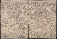
Orbis terrarvm typvs de integro multis in locis emendatus
Description:
Copy 2: Imperfect: chipped along folds, with some loss of text. Backed with paper. and Double hemispherical map of the world, with 2 smaller celestial hemispheres. New Guinea shown as part of southern continent called Magallanica. The two hemispheres are surr
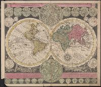
Vlakke aard-kloot met het beide hemelsch half-rond, of de onder scheidene verbeelding van de land-water-waereld
Description:
"De Warmoes Straat sub signo R. Visschers Athlas"., Cross collection no. 29., Double hemispherical world map showing routes of explorers including Magellan, Dampier, Tasman and Chaumont., Includes twenty-six smaller astronomical diagrams and hemispheres of the world, two larger celestial hemispheres and textual commentary., and Relief shown pictorially.
Publisher:
Ex officina Petri Schenkii ...,
Subject (Geographic):
Australia--Maps--Early works to 1800
Subject (Name):
Schenk, Peter, 1660-1718 or 1719. Atlas contractus
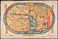
Peutinger table. and Tabula itineraria ex illustri Peutingerorum
Description:
Tabvlae Pevtingerianae segmentvm primvm, ab ostiis Rheni bonnam vsque -- Segmentvm secvndvm à bonna vsque ad Marcomannos -- Tabvlae Pevtingerianae segmentvm III a Marcomannis ad Sarmatas vsque -- Segmentvm IV a Sarmatis vsque ad Hamaxobios -- Tabvlae Pevtingerianae segmentvm V a Sarmatis Hamaxobis vsque ad Roxulanas -- Segmentvm VI a Sarmatis Roxulanis vsque ad Parnacos -- Tabvlae Pevtingerianae segmentvm VII a Parnacis vsque ad Paralocas Schythas -- Segmentvm VIII a Paralocis Schythis vsque ad finem Asiae.
Publisher:
prostant apud Joannem Janssonium,
Subject (Name):
Horn, Georg, 1620-1670, Jansson, Jan, 1588-1664. Accuratissima Orbis antiqui delineatio... [1652?], Jansson, Jan, 1588-1664. Novus atlas, Peutinger, Konrad, 1465-1546 or 7, and Welser, Marcus, 1558-1614
Subject (Topic):
Roads, Roman--Maps--Early works to 1800 and World maps--Early works to 1800
Horn, Georg, 1620-1670 Jansson, Jan, 1588-1664. Accuratissima Orbis antiqui delineatio... [1652?] Jansson, Jan, 1588-1664. Novus Atlas Peutinger, Konrad, 1465-1546 or 7 Welser, Marcus, 1558-1614
Published / Created:
1652?]
Call Number:
314 1654
Container / Volume:
BRBL_00038
Image Count:
4
Resource Type:
Maps, Atlases & Globes
Alternative Title:
Peutinger table. and Tabula itineraria ex illustri Peutingerorum
Description:
From: Accuratissima Orbis antiqui delineatio...by J. Jansson [1652?], Jansson's Peutinger table was reprinted in various editions of Accuratissima Orbis antiqui delineatio and in later editions edited by Georg Horn. Map also appeared in, and Lanman collection.
Publisher:
prostant apud Joannem Janssonium,
Subject (Geographic):
Roman Empire Maps--Early works to 1800
Subject (Topic):
Roads, Roman--Maps--Early works to 1800 and World maps--Early works to 1800
Decorated with sea monsters, mermaids, exotic animals, and cannibals, this wood cut map provides a marked contrast to the simplistic diagrams considered the earliest printed world maps. While the latter presented a world view based in Judeo-Christian theo
Alternative Title:
Typus cosmographicus universalis and Typvs cosmographicvs vniversalis
Description:
Appears in Johann Huttich's Novus orbis regionum. Basel. 1532. and Relief shown pictorially.
Publisher:
[publisher not identified],
Subject (Name):
Holbein, Hans, 1497-1543 and Huttich, Johann, 1480?-1544. Novus orbis regionum.
"Photolithographed copy of Gerard Mercator's Mapamundi of 1538 from an original engraving in the library of the American Geographical Society.", Relief shown pictorially., and Title devised by cataloger.
Publisher:
Julius Bien & Co., photo-lith,
Subject (Geographic):
World--Maps--Early works to 1800
Subject (Name):
American Geographical Society of New York and Julius Bien & Co
Subject (Topic):
Early maps, Early maps--Facsimiles, World maps, and World maps--Early works to 1800