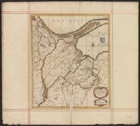
"Cum priv: poten: D.D. ord: Holl: et West-Frisiae"., Appeared in Valk and Schenk's Atlantis sylloge compendiosa, ca. 1702., Backed with paper. Ms. no. "35" in upper left-hand corner. Sheet measures 53.6 x 62.5 cm. No. 34 of 87 maps bound together., Bar scales given in "milliaria Germanica," "milliaria Gallica," and "milliaria Italica"., Prime meridian: Ferro., Relief shown pictorially., and Watermark.
Publisher:
Gerard Valk,
Subject (Geographic):
Rhineland-Palatinate (Germany)--Maps--Early works to 1800.
Subject (Name):
Schenk, Peter, 1660-1718 or 1719. Atlantis sylloge compendiosa. and Valck, G. (Gerard), 1651 or 2-1726. Atlantis sylloge compendiosa.
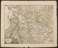
Tribvs Aser, et partes occidentales tribuum Zabvlon et Isachar
Description:
Appears in Jansson's historical atlas editions from 1652-1684 and in his Accuratissima orbis antiqui delineatio. From 1653 on, this work is known under the name of Hornius, who wrote the text and compiled all the maps for the atlases--(Koeman-Krogt. 1:601-1:607)., Coordinates not present on map and are approximated., Map indexed with grid lines and alphabet letters A-H at bottom., Oriented with north toward the left., Printed on one and a half sheets., Relief shown pictorially., Shows the Tribe of Asher and the western parts of Zabulon and Isachar., and Watermark. Manuscript numbers in upper left and right corners: 43. No. 3 of 6 maps housed together.
Publisher:
[Jan Jansson],
Subject (Geographic):
Palestine--History--To 70 A.D.--Maps--Early works to 1800. and Palestine--Maps--Early works to 1800.
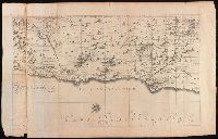
Appears in: Theatrum Terrae Sanctae et biblicarum historiarum / Christiaan van Adrichem. Colonia Agrippina : Birckmannica, 1590., Cartographer from dealer's notes., Has watermark., Oriented with north toward the left., Relief shown pictorially., and Shows portion
Publisher:
Birckmannica,
Subject (Geographic):
Palestine--History--To 70 A.D.--Maps and Palestine--Maps--Early works to 1800