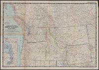
National Geographic Society (U.S.). Cartographic Section
Published / Created:
1950
Call Number:
845 1950
Container / Volume:
BRBL_00620
Image Count:
1
Resource Type:
Maps, Atlases & Globes
Description:
"Compilation by H.C. Bryan, R.W. Collins, R.J. Daily, A.D. Grozzini, and A.E. Holdstock. Relief by John J. Brehm.", Inset map: Puget Sound Region, scale 1:1,000,000 or 15.8 miles to the inch., and Issued as supplement to National Geographic, v.97, no. 6, June 1950.
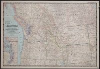
National Geographic Society (U.S.). Cartographic Section
Published / Created:
1950
Call Number:
80 1950
Container / Volume:
BRBL_00536
Image Count:
1
Resource Type:
Maps, Atlases & Globes
Description:
"Compilation by H.C. Bryan, R.W. Collins, R.J. Darley, A.D. Grazzini, and A.E. Holdstock. Relief by John J. Brehm.", Inset: Puget Sound Region. Scale 1:1,000,000 or 15.8 miles to the in., Issued as supplement to National Geographic, v.97, no. 6, June 1950., and Relief shown by shading and spot heights.
Publisher:
The Society,
Subject (Geographic):
Alberta--Maps, British Columbia--Maps, Northwest, Pacific--Maps, and Saskatchewan--Maps
Subject (Name):
Brehm, J. J, Bryan, H. C, Collins, R. W, Darley, James M. (James Morrison), Darley, Richard J, Grazzini, Athos D, and Holdstock, A. E
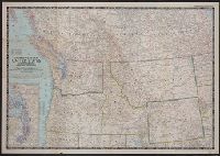
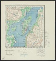
Great Britain. War Office. General Staff. Geographical Section
Published / Created:
1942,
Call Number:
344 T75 1943
Container / Volume:
BRBL_00094
Image Count:
1
Resource Type:
Maps, Atlases & Globes
Alternative Title:
Geographical Section, General Staff ; No. 4246, GSGS (Series) ; 4246., and Tromsö omegn
Description:
"Contour interval 30 metres.", "Reproduced from Norwegian map of 1932 by O.S., 1942.", "War Office, 1942.", Includes notes and diagrams., Military grid., and Relief shown by contours and spot heights.