Subject: Map of New England and Long Island with the states divided into cities and towns. Cartouche at lower right shows Liberty leading a Native American and pilgrims to Plymouth Rock.
Description:
"Observations on which this map is grounded.", Copy 2: Imperfect: southern sheet wanting., Includes compilation data and insets of "A plan of the town of Boston" and "A plan of the town of Boston Harbor from an accurate sur, and Prime meridian: London and Ferro.
Publisher:
November 29th 1774 Published according to Act by Thos. Jefferys geographer to His Royal Highness the Prince of Wales near Charing Cross,
Subject: Map of New England and Long Island with the states divided into cities and towns. Cartouche at lower right shows Liberty leading a Native American and pilgrims to Plymouth Rock.
Description:
"Observations on which this map is grounded.", Dissected and mounted on linen., Includes compilation data and insets of "A plan of the town of Boston" and "A plan of the town of Boston Harbor from, Prime meridian: London and Ferro., and Relief shown pictorially.
Publisher:
November 29th 1774 Published according to Act by Thos. Jefferys geographer to His Royal Highness the Prince of Wales near Charing Cross,
Subject: Map of New England and Long Island with the states divided into cities and towns. Cartouche at lower right shows Liberty leading a Native American and pilgrims to Plymouth Rock.
Description:
"Observations on which this map is grounded.", Copy 2: Imperfect: southern sheet wanting., Includes compilation data and insets of "A plan of the town of Boston" and "A plan of the town of Boston Harbor from an accurate survey," ca. 1:150,000., and Prime meridia
Publisher:
November 29th 1774 Published according to Act by Thos. Jefferys geographer to His Royal Highness the Prince of Wales near Charing Cross,
Subject: Map of New England and Long Island with the states divided into cities and towns. Cartouche at lower right shows Liberty leading a Native American and pilgrims to Plymouth Rock.
Description:
"Observations on which this map is grounded.", Copy 1: Dissected and mounted on linen., Includes compilation data and insets of "A plan of the town of Boston" and "A plan of the town of Boston Harbor from an accurate survey," ca. 1:150,000., and Prime meridian:
Publisher:
November 29th 1774 Published according to Act by Thos. Jefferys geographer to His Royal Highness the Prince of Wales near Charing Cross,
Subject: Map of Hudson River from New York City to Lake George, with plans of Fort Edward and Fort William Henry. Also includes views of the first and second engagements during the Battle of Lake George. In the "First engagement" soldiers are seen shootin
Description:
771hc H864 1756: Stamp "Yale Horace Brown 1900S." Accompanied by reproduction of map [with stamp "Yale Horace Brown 1900S"]. and Coordinates not present on map of Hudson River and are approximated.
Publisher:
Published according to act of Parliament,
Subject (Geographic):
Hudson River (N.Y. and N.J.)--Maps, New York (State)--Lake George, United States--History--French and Indian War, 1754-1763--Campaigns--Pictorial works, and United States--Hudson River
Subject (Name):
Brown, Horace--Stamp, French and Indian War (United States : 1754-1763), Jefferys, Thomas, -1771, engraver, and Lake George, Battle of (New York : 1755)
Subject (Topic):
Lake George, Battle of, N.Y., 1755--Pictorial works
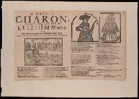
Call to Charon and Discontented lover overcome with grief
Description:
BEIN 2000 Folio 6 14: Mounted to 30 x 42 cm., Place of publication and date from Wing., and This may be printed, R.P."
Publisher:
Printed for C. Dennisson ...,
Subject (Topic):
Ballads, English--England--Texts, Charon (Greek mythology)--Poetry--Early works to 1800, Death--Poetry--Early works to 1800, and Elysium--Poetry--Early works to 1800