Homann Erben (Firm) L'Isle, Guillaume de, 1675-1726 Riccioli, Giovanni Battista, 1598-1671
Published / Created:
[1742?]
Call Number:
1983 Folio 23
Collection Title:
[Atlas factice of 50 maps, primarily by Johann Baptist Homann and/or issued by the Homann Erben
Image Count:
1
Alternative Title:
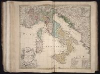
Gli stati d'Italia secondo le osservationi fatte dalla Societa di Se di Parigi, dal R.P. Riccioli della S. die Giesu ed. altri astronomi, di prima geograficamente delineati ... Sgr. de l'Isle ... alle spese degl' heredi d'Homann l'Anno MDCCXLII
Homann Erben (Firm) L’Isle, Guillaume de, 1675-1726 Riccioli, Giovanni Battista, 1598-1671
Published / Created:
[1742?]
Call Number:
1973 Folio 30
Collection Title:
[Atlas factice of 32 maps and 1 distance table, produced by the Homann Erben firm]
Image Count:
2
Alternative Title:
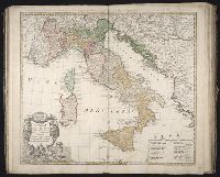
Gli stati d’Italia secondo le osservationi fatte dalla Societa di Se di Parigi, dal R.P. Riccioli della S. die Giesu ed. altri astronomi, di prima geograficamente delineati ... Sgr. de l’Isle ... alle spese degl’ heredi d’Homann l’Anno MDCCXLII
Gli stati d'Italia secondo le osservationi fatte dalla Societa di Se di Parigi, dal R.P. Riccioli della S. die Giesu ed. altri astronomi, di prima geograficamente delineati ... Sgr. de l'Isle ... alle spese degl' heredi d'Homann l'Anno MDCCXLII
Description:
Includes 14 bar scales., Relief shown pictorially., and Sheet measures 54.5 x 61.2 cm.
Publisher:
Curantibus Homannianis Heredibus,
Subject (Geographic):
Italy--Maps--Early works to 1800
Subject (Name):
L'Isle, Guillaume de, 1675-1726 and Riccioli, Giovanni Battista, 1598-1671
Iimage of the Saints Maurus and Placid surrounded by angels in lower left corner., Publisher statement precedes place of publication in imprint., Relief shown pictorially., and Watermark. Manuscript number in right corner: 42. From the Karpinski-von Wieser Map Collection.
Publisher:
Excusa per Haeredes Homan[n]ianos
Subject (Geographic):
Italy--Maps--Early works to 1800.
Subject (Name):
Benedictines and Benedictines--Italy--Maps--Early works to 1800
Subject (Topic):
Ecclesiastical geography and Ecclesiastical geography--Italy--Maps--Early works to 1800.
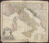
Appeared in various editions of Jan Jansson's Accuratissima orbis antiqui delineatio., Coordinates not accurate as presented on map and are approximated., Relief shown pictorially., and Watermark. Manuscript number in upper left corner: 15.
Publisher:
[Jan Jansson],
Subject (Geographic):
Cisalpine Republic--Maps--Early works to 1800. and Lombardy (Italy)--Maps--Early works to 1800.
Subject (Name):
Jansson, Jan, 1588-1664. Accuratissima orbis antiqui delineatio. and Ortelius, Abraham, 1527-1598
Subject (Topic):
Historical geography--Italy--Lombardy--Maps--Early works to 1800.
Manuscript on parchment of Biondo Flavio, Italia Illustrata with the dedicatory preface to Pope Nicolas V (d. 1455).
Description:
Binding: Eighteenth century, England. Red goatskin gold-tooled, with the crest of Charles Chauncy on the sides. Gilt edges. Rebacked. The fine quality of the endleaves and leather, and the tool used on the edges of the boards and the turn-ins are similar to those in Marston MS 102 and Beinecke MS 497, both probably bound by Richard Wier, active in London and France in the 1770s; d. 1792)., Elaborately illuminated title page with historiated initial, 10-line, mauve with silver filigree against gold ground, edged in black, with a portrait of the author, seated and holding a book, against a hilly landscape and blue sky. Partial border of white vine-stem ornament against a predominantly gold ground with blue, green, and red patches with white and pale yellow dots in inner and upper margins, terminating in dense penwork scrolls with gold dots. In outer and lower margin, border of stylized flowers and foliage in red, purple, green, and blue, surrounded by dense penwork scrolls punctuated by gold dots. In center of lower margin, wreathed medallion with unidentified arms, supported by two purple winged putti outlined in blue and wearing red necklaces. 14 illuminated initials, 9- to 6-line, gold, on blue, green, and red ground with white vine-stem ornament, sometimes extending into the margins. Headings, running titles, and marginalia in red., and Script: Written in fine humanistic bookhand, below top line, by a single scribe who also wrote the running titles (epigraphic majuscules) and marginalia, in red.
Subject (Geographic):
Italy--Description and travel
Subject (Topic):
Geography, Medieval, Illumination of books and manuscripts, Medieval, Manuscripts, Medieval--Connecticut--New Haven, and Medieval and Renaissance Manuscripts in Beinecke Library
"Cum privilegio potentiss. D.D. ordin: Hollandiae et Westfrisiae.", Backed with paper. Ms. no. "65" in upper right corner. Sheet measures 53.7 x 62.5 cm. No. 60 of 87 maps bound together., Bar scales given in milliaria "Italica," "Germanica," and "Gallica.", Includes inset map of Sicily., Prime meridian: Ferro., and Relief shown pictorially.