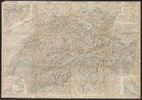
Carta stradale della Svizzera, Carte routière de la Suisse, Reisekarte der Schweiz, and Road map of Switzerland
Description:
In French. Legend and scales in French, English, German, and Italian., Includes insets of northwestern Europe, north-central Europe, northern Italy, and the French-Italian coastal region., Mounted on verso: Luzern, and Relief shown by hachures and spot heights.
Carta stradale della Svizzera, Carte routière de la Suisse, Reisekarte der Schweiz, and Road map of Switzerland
Description:
In French. Legend and scales in French, English, German, and Italian., Includes insets of northwestern Europe, north-central Europe, northern Italy, and the French-Italian coastal region., Library copy annotated in, and Relief shown by hachures and spot heights.
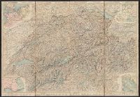
Carta stradale della Svizzera, Carte routière de la Suisse, Reisekarte der Schweiz, and Road map of Switzerland
Description:
In French. Legend and scales in French, English, German, and Italian., Includes insets of northwestern Europe, north-central Europe, northern Italy, and the French-Italian coastal region., and Mounted on verso: Luzern -- Bâle -- Genève -- Zuric -- Berne -- La
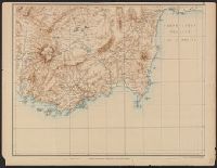
Carte de la partie occidentale de l 'Asie mineure and Map of the western part of Asia Minor
Description:
Covers western Anatolia and islands in Aegean Sea., Map in German; title in German, French, and English., Relief shown by shading and spot heights., and Sheet XV. only
Publisher:
Verlag von Dietrich Reimer,
Subject (Geographic):
Aegean Islands (Greece and Turkey)--Maps and Turkey--Maps
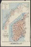
4. Heigoland -- 15. Jever., Accompanied text: Nachricht. [4] p. ; 48 cm., Imperfect: all sheets but 4 and 15 wanting. Addressed in manuscript to Louis C. Karpinski from Fr. Karafiat, with postage stamps, on verso. Printed key for sheets 4, 14 and 15 pasted on verso., Indexed., and Relief shown pictorially by hachures and form lines.