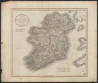
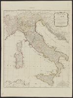
Dedication under coat of arms inscribed Honi Soit Qui Mal y Pense: To His Most Sacred Majesty George by the grace of God King of Great Britain, France and Ireland &c. this map is most humbly dedicated by His Majesty's most loyal & obedient subject and ser
Publisher:
Robt. Sayer at the Golden Buck in Fleet Street,
Subject (Geographic):
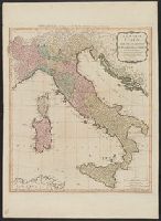
Italy--Administrative and political divisions--Maps--Early works to 1800 and Italy--Maps--Early works to 1800
Subject (Name):
Overton, Henry, 1675 or 6-1751 and Sayer, Robert, 1725-1794
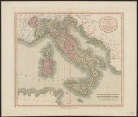
Carte de l'Italie et de touts ses routes de poste, à l'usage de voyageurs
Description:
Appears in Laurie and Whittle, A new universal atlas, 1796, plate 16., Horizontal fold at middle of map and guard on verso., Includ, Relief shown pictorially., and Sheet measures 72 x 54 cm. Stamp on verso: Karpinski-von Wieser Map Collection. dgvmp2008.
Publisher:
Laurie & Whittle,
Subject (Geographic):
Italy--Maps--Early works to 1800
Subject (Name):
Anville, Jean Baptiste Bourguignon d', 1697-1782 and Robert Laurie and James Whittle
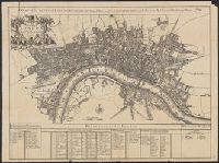
A plan of the City's of London, Westminster and Borough of Southwark; with the new Additional Buildings Anno. 1720., E. Weller, litho. London, Cassel & Co., [1910?], and Index to names on map in margin.
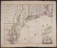
Also shows anchorages, currents, and routes of navigation along the coast., Includes historical notes, text, 10 insets of harbors, and a table showing that "North America is divided into the continent & the islands" according to geography and politics., and Rel
Publisher:
Printed for Robt. Sayer,
Subject (Geographic):
North America--Maps--Early works to 1800
Subject (Name):
Anville, Jean Baptiste Bourguignon d', 1697-1782 and Robert de Vaugondy, Didier, 1723-1786