Search
You Searched For
Search Results
- Published / Created:
- 1919?]
- Call Number:
- 11hcf 1919B-20-7
- Container / Volume:
- BRBL_00010P
- Image Count:
- 2
- Resource Type:
- Maps, Atlases & Globes
- Found in:
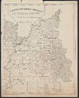
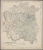
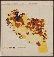
- Beinecke Rare Book and Manuscript Library > A Magyarorszagi Nepfajok Az Ország Mélyén / Tervezte: Balogh Pál ; Rajzolta: Br. Proff Kocsárd.
- Published / Created:
- 1919?]
- Call Number:
- 11hcf 1919B-20-7
- Container / Volume:
- BRBL_00010P
- Image Count:
- 2
- Resource Type:
- Maps, Atlases & Globes
- Found in:
- Beinecke Rare Book and Manuscript Library > A Magyarorszagi Nepfajok Az Ország Mélyén / Tervezte: Balogh Pál ; Rajzolta: Br. Proff Kocsárd.
- Published / Created:
- 1919?]
- Call Number:
- 11hcf 1919B-20-13
- Container / Volume:
- BRBL_00010P
- Image Count:
- 2
- Resource Type:
- Maps, Atlases & Globes
- Found in:
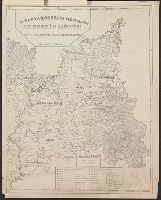
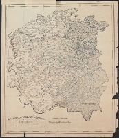
- Beinecke Rare Book and Manuscript Library > A Magyarorszagi Nepfajok Delkeleten / Tervezte: Balogh Pál ; Rajzolta: Br. Proff Kocsárd.
- Published / Created:
- 1919?]
- Call Number:
- 11hcf 1919B-20-13
- Container / Volume:
- BRBL_00010P
- Image Count:
- 2
- Resource Type:
- Maps, Atlases & Globes
- Found in:
- Beinecke Rare Book and Manuscript Library > A Magyarorszagi Nepfajok Delkeleten / Tervezte: Balogh Pál ; Rajzolta: Br. Proff Kocsárd.
- Published / Created:
- 1919?]
- Call Number:
- 11hcf 1919B-20-10
- Container / Volume:
- BRBL_00010P
- Image Count:
- 2
- Resource Type:
- Maps, Atlases & Globes
- Found in:
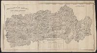
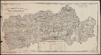
- Beinecke Rare Book and Manuscript Library > A Magyarorszagi Nepfajok Délen / Tervezte: Balogh Pál ; Rajzolta: Br. Proff Kocsárd.
- Published / Created:
- 1919?]
- Call Number:
- 11hcf 1919B-20-10
- Container / Volume:
- BRBL_00010P
- Image Count:
- 2
- Resource Type:
- Maps, Atlases & Globes
- Found in:
- Beinecke Rare Book and Manuscript Library > A Magyarorszagi Nepfajok Délen / Tervezte: Balogh Pál ; Rajzolta: Br. Proff Kocsárd.
- Creator:
- Gaudy, John
- Published / Created:
- 1715?]
- Call Number:
- 72 1715
- Container / Volume:
- BRBL_00372
- Image Count:
- 1
- Resource Type:
- Maps, Atlases & Globes
- Found in:
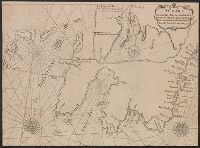
- Beinecke Rare Book and Manuscript Library > A chart, shewing part of the sea coast of Newfoundland from the Bay of Bulls to Little Placentia / exactly and carefully lay'd down by John Gaudy, anno 1715.
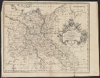
- Published / Created:
- 1770]
- Call Number:
- 36 1770H
- Container / Volume:
- BRBL_00118
- Image Count:
- 1
- Resource Type:
- Maps, Atlases & Globes
- Found in:
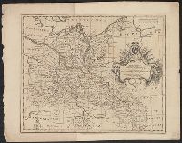
- Beinecke Rare Book and Manuscript Library > A correct map of the north east part of Germany...
- Published / Created:
- 1770]
- Call Number:
- 36 1770G
- Container / Volume:
- BRBL_00118
- Image Count:
- 1
- Resource Type:
- Maps, Atlases & Globes
- Found in:
- Beinecke Rare Book and Manuscript Library > A correct map of the north east part of Germany...
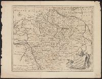
- Published / Created:
- 1770]
- Call Number:
- 36 1770A
- Container / Volume:
- BRBL_00118
- Image Count:
- 1
- Resource Type:
- Maps, Atlases & Globes
- Found in:
- Beinecke Rare Book and Manuscript Library > A correct map of the north west part of Germany...
- Published / Created:
- 1770]
- Call Number:
- 36 1770B
- Container / Volume:
- BRBL_00118
- Image Count:
- 1
- Resource Type:
- Maps, Atlases & Globes
- Found in:
- Beinecke Rare Book and Manuscript Library > A correct map of the north west part of Germany...
- Published / Created:
- 1770]
- Call Number:
- 36 1770F
- Container / Volume:
- BRBL_00118
- Image Count:
- 1
- Resource Type:
- Maps, Atlases & Globes
- Found in:
- Beinecke Rare Book and Manuscript Library > A correct map of the south east part of Germany...
- Published / Created:
- 1770]
- Call Number:
- 36 1770E
- Container / Volume:
- BRBL_00118
- Image Count:
- 1
- Resource Type:
- Maps, Atlases & Globes
- Found in:
- Beinecke Rare Book and Manuscript Library > A correct map of the south east part of Germany...
- Published / Created:
- 1860?]
- Call Number:
- 796gme 1860
- Container / Volume:
- BRBL_00531
- Image Count:
- 1
- Resource Type:
- Maps, Atlases & Globes
- Found in:
- Beinecke Rare Book and Manuscript Library > A geographically correct map of the Red River, Sabine & Western Railway (under construction) and connections : showing distribution of pine forests (compiled from maps of U.S. government), also location of coal, iron, and oil deposits.
- Published / Created:
- 178-?]
- Call Number:
- 71 1780C
- Container / Volume:
- BRBL_00366
- Image Count:
- 1
- Resource Type:
- Maps, Atlases & Globes
- Found in:
- Beinecke Rare Book and Manuscript Library > A map of America between latitudes 40 and 70 north, and longitudes 45 and 180 west : exhibiting the principal trading stations of the North West Company.
- Creator:
- Anville, Jean Baptiste Bourguignon d', 1697-1782
- Published / Created:
- 17--?]
- Call Number:
- 71 1769A
- Container / Volume:
- BRBL_00364
- Image Count:
- 1
- Resource Type:
- Maps, Atlases & Globes
- Found in:
- Beinecke Rare Book and Manuscript Library > A map of North America : from D'Anville, 1769.
- Published / Created:
- ca 1810]
- Call Number:
- 773 J487 1810
- Container / Volume:
- BRBL_00496
- Image Count:
- 1
- Resource Type:
- Maps, Atlases & Globes
- Found in:
- Beinecke Rare Book and Manuscript Library > A map of that part of the town of Jersey, commonly called Aharsimus.
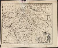
- Published / Created:
- 1770]
- Call Number:
- 36 1770D
- Container / Volume:
- BRBL_00118
- Image Count:
- 1
- Resource Type:
- Maps, Atlases & Globes
- Found in:
- Beinecke Rare Book and Manuscript Library > A new and correct map of the south west part of Germany...
- Published / Created:
- 1770]
- Call Number:
- 36 1770C
- Container / Volume:
- BRBL_00118
- Image Count:
- 1
- Resource Type:
- Maps, Atlases & Globes
- Found in:
- Beinecke Rare Book and Manuscript Library > A new and correct map of the south west part of Germany...
- Creator:
- Parker, John Henry, 1806-1884
- Published / Created:
- 1882]
- Call Number:
- 40 R66 1882
- Container / Volume:
- BRBL_00219
- Image Count:
- 1
- Resource Type:
- Maps, Atlases & Globes
- Found in:
- Beinecke Rare Book and Manuscript Library > A plan of Rome, ancient and modern [cartographic material] : with indications of the ancient walls, streets and gates according to Pliny / by John Henry Parker.
- Creator:
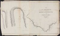
- Featherstonhaugh, George William, 1780-1866
- Published / Created:
- 1835]
- Call Number:
- 814 M667 1835
- Container / Volume:
- BRBL_00558
- Image Count:
- 1
- Resource Type:
- Maps, Atlases & Globes
- Found in:
- Beinecke Rare Book and Manuscript Library > A reconnoissance of the Minnay Sotor Watapāh; or St. Peter's River to its sources / made in the year 1835 by G.W. Featherstonhaugh, U.S. geologist.
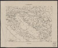
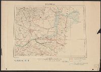
- Published / Created:
- 1919?]
- Call Number:
- 11hcf 1919B-29
- Container / Volume:
- BRBL_00010Q
- Image Count:
- 1
- Resource Type:
- Maps, Atlases & Globes
- Found in:
- Beinecke Rare Book and Manuscript Library > Adriatic.
- Published / Created:
- 1919?]
- Call Number:
- 11hcf 1919B-45
- Container / Volume:
- BRBL_00010R
- Image Count:
- 1
- Resource Type:
- Maps, Atlases & Globes
- Found in:
- Beinecke Rare Book and Manuscript Library > Albania.
- Published / Created:
- 1900?]
- Call Number:
- 475CBD 1900
- Container / Volume:
- BRBL_00262
- Image Count:
- 1
- Resource Type:
- Maps, Atlases & Globes
- Found in:
- Beinecke Rare Book and Manuscript Library > Albania.
- Creator:
- Jode, Cornelis de, 1568-1600
- Published / Created:
- 19--?]
- Call Number:
- 71 1593
- Container / Volume:
- BRBL_00359
- Image Count:
- 1
- Resource Type:
- Maps, Atlases & Globes
- Found in:
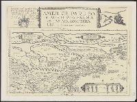
- Beinecke Rare Book and Manuscript Library > Americae pars borealis, Florida, Baccalaos, Canada, Corterealis / A Cornelio de Iudaeis in luce edita.
- Published / Created:
- between 1722 and 1799?]
- Call Number:
- 70 1722A
- Container / Volume:
- BRBL_00355
- Image Count:
- 1
- Resource Type:
- Maps, Atlases & Globes
- Found in:
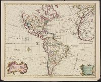
- Beinecke Rare Book and Manuscript Library > Amerika.
- Published / Created:
- 1919?]
- Call Number:
- 11hcf 1919B-40
- Image Count:
- 1
- Resource Type:
- Maps, Atlases & Globes
- Found in:
- Beinecke Rare Book and Manuscript Library > Anatolia and Armenia.
- Published / Created:
- 1919?]
- Call Number:
- 11hcf 1919B-43
- Image Count:
- 1
- Resource Type:
- Maps, Atlases & Globes
- Found in:
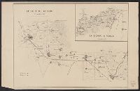
- Beinecke Rare Book and Manuscript Library > Areas and population of Dalmatian Islands in 1900 : Official Austrian census.
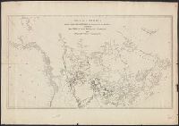
- Creator:
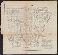
- Arkansas. Surveyor's Office
- Published / Created:
- 1855]
- Call Number:
- 818 1855B
- Container / Volume:
- BRBL_00565
- Image Count:
- 1
- Resource Type:
- Maps, Atlases & Globes
- Found in:
- Beinecke Rare Book and Manuscript Library > Arkansas / Surveyor's Office Little Rock Oct. 18th 1855. Henry M. Rector, Sur. Genl. of Arks.
- Published / Created:
- 1919?]
- Call Number:
- 11hcf 1919B-41
- Container / Volume:
- BRBL_00010R
- Image Count:
- 1
- Resource Type:
- Maps, Atlases & Globes
- Found in:
- Beinecke Rare Book and Manuscript Library > Asia.
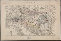
- Published / Created:
- 1910?]
- Call Number:
- 41fac 1910
- Container / Volume:
- BRBL_00243
- Image Count:
- 2
- Resource Type:
- Maps, Atlases & Globes
- Found in:
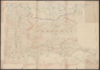
- Beinecke Rare Book and Manuscript Library > Austria Hungary ... Hungary by Administrative divisions of 1910.
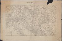
- Published / Created:
- 1919?]
- Call Number:
- 11hcf 1919C-3-1
- Container / Volume:
- BRBL_00010U
- Image Count:
- 1
- Resource Type:
- Maps, Atlases & Globes
- Found in:
- Beinecke Rare Book and Manuscript Library > Austria Hungary, Scale 1:3,000,000.
- Published / Created:
- 1919?]
- Call Number:
- 11hcf 1919C-3-1
- Container / Volume:
- BRBL_00010U
- Image Count:
- 1
- Resource Type:
- Maps, Atlases & Globes
- Found in:
- Beinecke Rare Book and Manuscript Library > Austria Hungary, Scale 1:3,000,000.
- Published / Created:
- 1919?]
- Call Number:
- 11hcf 1919C-3-1
- Container / Volume:
- BRBL_00010U
- Image Count:
- 1
- Resource Type:
- Maps, Atlases & Globes
- Found in:
- Beinecke Rare Book and Manuscript Library > Austria Hungary, Scale 1:3,000,000.
- Creator:
- Atkins, Paul M. (Paul Moody), 1892-
- Published / Created:
- 1910]
- Call Number:
- 41gc 1910
- Container / Volume:
- BRBL_00243
- Image Count:
- 1
- Resource Type:
- Maps, Atlases & Globes
- Found in:
- Beinecke Rare Book and Manuscript Library > Austria-Hungary : Population actively engaged in Agriculture Paul M. Atkins.
- Creator:
- Atkins, Paul M. (Paul Moody), 1892-
- Published / Created:
- 1910]
- Call Number:
- 41gf 1910
- Container / Volume:
- BRBL_00243
- Image Count:
- 1
- Resource Type:
- Maps, Atlases & Globes
- Found in:
- Beinecke Rare Book and Manuscript Library > Austria-Hungary : Population actively engaged in Industry Paul M. Atkins.
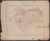
- Published / Created:
- 1919]
- Call Number:
- 11hcf 1919B-5
- Container / Volume:
- BRBL_00010S
- Image Count:
- 1
- Resource Type:
- Maps, Atlases & Globes
- Found in:
- Beinecke Rare Book and Manuscript Library > Austria-Hungary : Population density of Jugo-slavia.
- Published / Created:
- 1910?]
- Call Number:
- 41 1910A
- Container / Volume:
- BRBL_00241
- Image Count:
- 1
- Resource Type:
- Maps, Atlases & Globes
- Found in:
- Beinecke Rare Book and Manuscript Library > Austria-Hungary.
- Published / Created:
- 1910?]
- Call Number:
- 11hcf 1919C-14
- Image Count:
- 1
- Resource Type:
- Maps, Atlases & Globes
- Found in:
- Beinecke Rare Book and Manuscript Library > Austria-Hungary.
- Published / Created:
- 1919?].
- Call Number:
- 11hcf 1919C-3-14
- Container / Volume:
- BRBL_00010U
- Image Count:
- 1
- Resource Type:
- Maps, Atlases & Globes
- Found in:
- Beinecke Rare Book and Manuscript Library > Austria-Hungary.
- Published / Created:
- 1919?]
- Call Number:
- 11hcf 1919C-3-17
- Container / Volume:
- BRBL_00010U
- Image Count:
- 1
- Resource Type:
- Maps, Atlases & Globes
- Found in:
- Beinecke Rare Book and Manuscript Library > Austria-Hungary.
- Published / Created:
- 1919?]
- Call Number:
- 11hcf 1919C-3-16
- Container / Volume:
- BRBL_00010U
- Image Count:
- 1
- Resource Type:
- Maps, Atlases & Globes
- Found in:
- Beinecke Rare Book and Manuscript Library > Austria-Hungary.
- Published / Created:
- 1919?]
- Call Number:
- 11hcf 1919C-3-8
- Container / Volume:
- BRBL_00010U
- Image Count:
- 1
- Resource Type:
- Maps, Atlases & Globes
- Found in:
- Beinecke Rare Book and Manuscript Library > Austria-Hungary.
- Published / Created:
- 1880?]
- Call Number:
- 3627 B14 1880
- Image Count:
- 2
- Resource Type:
- Maps, Atlases & Globes
- Found in:
- Beinecke Rare Book and Manuscript Library > Baierbrunn.
- Published / Created:
- 1886
- Call Number:
- 44 1886
- Container / Volume:
- BRBL_00255
- Image Count:
- 2
- Resource Type:
- Maps, Atlases & Globes
- Found in:
- Beinecke Rare Book and Manuscript Library > Balkanhalbinsel.
- Published / Created:
- 1919]
- Call Number:
- 11hcf 1919B-33
- Container / Volume:
- BRBL_00010Q
- Image Count:
- 1
- Resource Type:
- Maps, Atlases & Globes
- Found in:
- Beinecke Rare Book and Manuscript Library > Baltic provinces.
- Published / Created:
- 1859]
- Call Number:
- 40hc 1859J
- Container / Volume:
- BRBL_00231
- Image Count:
- 1
- Resource Type:
- Maps, Atlases & Globes
- Found in:
- Beinecke Rare Book and Manuscript Library > Battaglia del Volturno.
- Creator:
- Peseux, M
- Published / Created:
- 1864
- Call Number:
- 801hc N17 1864
- Container / Volume:
- BRBL_00541
- Image Count:
- 1
- Resource Type:
- Maps, Atlases & Globes
- Found in:
- Beinecke Rare Book and Manuscript Library > Battlefields in front of Nashville where the United States forces commanded by Major General Geo. H. Thomas defeated and routed the Rebel army under General Hood, December 15th & 16th 1864 / surveyed and drawn under the direction of Gen: Tower by M. Peseu
- Published / Created:
- 1919]
- Call Number:
- 11hcf 1919B-14
- Container / Volume:
- BRBL_00010O
- Image Count:
- 1
- Resource Type:
- Maps, Atlases & Globes
- Found in:
- Beinecke Rare Book and Manuscript Library > Bulgarie.
- Published / Created:
- 19--?].
- Call Number:
- 38 C118 1960
- Container / Volume:
- BRBL_00156
- Image Count:
- 1
- Resource Type:
- Maps, Atlases & Globes
- Found in:
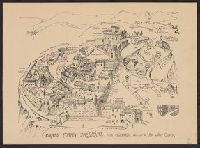
- Beinecke Rare Book and Manuscript Library > Cagnes Fortin Médiéval : Plan promenade / édité par les Amis du Vieux Cagnes.
- Published / Created:
- 1870?]
- Call Number:
- 4073cbf 1870
- Container / Volume:
- BRBL_00237
- Image Count:
- 3
- Resource Type:
- Maps, Atlases & Globes
- Found in:
- Beinecke Rare Book and Manuscript Library > Campania, section of Pozzuoli, Napoli, to Castellammare.
- Published / Created:
- 1870?]
- Call Number:
- 40AM R66 1870
- Container / Volume:
- BRBL_00228
- Image Count:
- 1
- Resource Type:
- Maps, Atlases & Globes
- Found in:
- Beinecke Rare Book and Manuscript Library > Carta Guida Monumentale di Roma / Ignazio Gigli dis. ... Giovanni Della Longa inc.
- Creator:
- Villavicencio, Manuel, 1822-1871
- Published / Created:
- 1858
- Call Number:
- 99 1858
- Container / Volume:
- BRBL_00679
- Image Count:
- 1
- Resource Type:
- Maps, Atlases & Globes
- Found in:
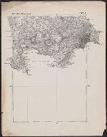
- Beinecke Rare Book and Manuscript Library > Carta corografica de la republica del Ecuador / Manuel Villavicencio ; lit. é imp. de F. Mayer y Ca.
- Creator:
- Villavicencio, Manuel, 1822-1871
- Published / Created:
- 1858
- Call Number:
- 99 1858
- Container / Volume:
- BRBL_00679
- Image Count:
- 1
- Resource Type:
- Maps, Atlases & Globes
- Found in:
- Beinecke Rare Book and Manuscript Library > Carta corografica de la republica del Ecuador / Manuel Villavicencio ; lit. é imp. de F. Mayer y Ca.
- Published / Created:
- 1850?]
- Call Number:
- 40 V248 1855
- Image Count:
- 1
- Resource Type:
- Maps, Atlases & Globes
- Found in:
- Beinecke Rare Book and Manuscript Library > Carta della Provincia della Valtellina / Giusseppe Pezze incise.
- Published / Created:
- 1671]
- Call Number:
- 70 1671
- Container / Volume:
- BRBL_00354
- Image Count:
- 1
- Resource Type:
- Maps, Atlases & Globes
- Found in:
- Beinecke Rare Book and Manuscript Library > Carte de l'Amerique : corrigée et augmentée, dessus toutes les aultres cy deuant, 1671.
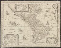
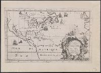
- Creator:
- Robert de Vaugondy, Didier, 1723-1786
- Published / Created:
- 1772]
- Call Number:
- 844 1772
- Container / Volume:
- BRBL_00601
- Image Count:
- 1
- Resource Type:
- Maps, Atlases & Globes
- Found in:
- Beinecke Rare Book and Manuscript Library > Carte de la Californie et des pays nord-ouest : separés de l'Asie par le Détroit d'Anian, extraite de deux cartes publiées au commencement du 17e siecle / par le S. Robert de Vaugondy ... 1772.
- Published / Created:
- 1772]
- Call Number:
- 844 1772A
- Container / Volume:
- BRBL_00601
- Image Count:
- 1
- Resource Type:
- Maps, Atlases & Globes
- Found in:
- Beinecke Rare Book and Manuscript Library > Carte de la Californie et des pays nord-ouest : separés de l'Asie par le Détroit d'Anian, extraite de deux cartes publiées au commencement du 17e siecle / par le S. Robert de Vaugondy ... 1772.
- Creator:
- Hennepin, Louis, 17th cent
- Published / Created:
- 19--?]
- Call Number:
- 71 1683
- Container / Volume:
- BRBL_00360
- Image Count:
- 1
- Resource Type:
- Maps, Atlases & Globes
- Found in:
- Beinecke Rare Book and Manuscript Library > Carte de la Nouvelle France : et de la Louisiane nouvellement decouverte dediee au roy l'an 1683 / par le Reverend Pere Louis Hennepin, missionaire recollect et notaire apostoliquen ; N.Guerard ... et fecit.
- Published / Created:
- 17--?].
- Call Number:
- 71 1760A
- Container / Volume:
- BRBL_00364
- Image Count:
- 1
- Resource Type:
- Maps, Atlases & Globes
- Found in:
- Beinecke Rare Book and Manuscript Library > Carte de la Nouvelle France : où se voit le cours des Grandes Rivieres de S. Laurens & de Mississipi, aujour d'hui S. Louis, aux environs des-quelles se trouvent les etats, païs, nations, peuples &c. de la Floride, de la Louïsiane, de la Virginie, de l
- Published / Created:
- 1906
- Call Number:
- 71 1906A
- Container / Volume:
- BRBL_00371
- Image Count:
- 2
- Resource Type:
- Maps, Atlases & Globes
- Found in:
- Beinecke Rare Book and Manuscript Library > Carte géologique de l'Amérique du nord / dressée d'apres les sources officielles des Etats Unis, du Canada, del la République du Mexique, de la Commission du Chemin de Fer Intercontinental, etc. ; Henry Ganett, géographe ; Bailey Willis, geologue.
- Creator:
- Jensen, M. K
- Published / Created:
- c1939.
- Call Number:
- 827 B284 1939
- Container / Volume:
- BRBL_00577
- Image Count:
- 1
- Resource Type:
- Maps, Atlases & Globes
- Found in:
- Beinecke Rare Book and Manuscript Library > City of Bartlesville, Oklahoma / compiled and drawn by M.K. Jensen.
- Creator:
- Shepard, Edwin
- Published / Created:
- 1877]
- Call Number:
- 844 Sa593 1877
- Container / Volume:
- BRBL_00610
- Image Count:
- 1
- Resource Type:
- Maps, Atlases & Globes
- Found in:
- Beinecke Rare Book and Manuscript Library > City of Santa Cruz, California, 1877 / compiled by Edwin Shepard.
- Published / Created:
- 1860?]
- Call Number:
- 40 C275 1860A
- Container / Volume:
- BRBL_00206
- Image Count:
- 1
- Resource Type:
- Maps, Atlases & Globes
- Found in:
- Beinecke Rare Book and Manuscript Library > Cne. di Casteggio Fo. XI (Allegato A).
- Published / Created:
- 1860?]
- Call Number:
- 40 C275 1860
- Container / Volume:
- BRBL_00206
- Image Count:
- 1
- Resource Type:
- Maps, Atlases & Globes
- Found in:
- Beinecke Rare Book and Manuscript Library > Cne. di Casteggio Fo. XI.
- Published / Created:
- 1860?]
- Call Number:
- 40 M841 1860
- Container / Volume:
- BRBL_00211
- Image Count:
- 1
- Resource Type:
- Maps, Atlases & Globes
- Found in:
- Beinecke Rare Book and Manuscript Library > Cne. di Mortara Fo. XVII.
- Published / Created:
- 1860?]
- Call Number:
- 40 St81 1860
- Image Count:
- 1
- Resource Type:
- Maps, Atlases & Globes
- Found in:
- Beinecke Rare Book and Manuscript Library > Cne. di Stradella. Fo. XIV.
- Published / Created:
- 1860?]
- Call Number:
- 40 St81 1860B
- Image Count:
- 1
- Resource Type:
- Maps, Atlases & Globes
- Found in:
- Beinecke Rare Book and Manuscript Library > Cne. di Stradella. Fo. XVI.
- Published / Created:
- 1860?]
- Call Number:
- 40 St81 1860C
- Image Count:
- 1
- Resource Type:
- Maps, Atlases & Globes
- Found in:
- Beinecke Rare Book and Manuscript Library > Cne. di Stradella. Fo. XVII.
- Published / Created:
- 1860?]
- Call Number:
- 40 St81 1860A
- Image Count:
- 1
- Resource Type:
- Maps, Atlases & Globes
- Found in:
- Beinecke Rare Book and Manuscript Library > Cne. di Stradella. Fo. XVIII.
- Published / Created:
- 1860?]
- Call Number:
- 40 V682 1860
- Container / Volume:
- BRBL_00227
- Image Count:
- 1
- Resource Type:
- Maps, Atlases & Globes
- Found in:
- Beinecke Rare Book and Manuscript Library > Cne. di Vigevano Fo. XXXII.
- Published / Created:
- 1860?]
- Call Number:
- 40 V867 1860E
- Container / Volume:
- BRBL_00227
- Image Count:
- 1
- Resource Type:
- Maps, Atlases & Globes
- Found in:
- Beinecke Rare Book and Manuscript Library > Cne. di Voghera Fo. LXI.
- Published / Created:
- 1860?]
- Call Number:
- 40 V867 1860C
- Container / Volume:
- BRBL_00227
- Image Count:
- 1
- Resource Type:
- Maps, Atlases & Globes
- Found in:
- Beinecke Rare Book and Manuscript Library > Cne. di Voghera Fo. XLIII.
- Published / Created:
- 1860?]
- Call Number:
- 40 V867 1860D
- Container / Volume:
- BRBL_00227
- Image Count:
- 1
- Resource Type:
- Maps, Atlases & Globes
- Found in:
- Beinecke Rare Book and Manuscript Library > Cne. di Voghera Fo. XLIV.
- Published / Created:
- 1860?]
- Call Number:
- 40 V867 1860B
- Container / Volume:
- BRBL_00227
- Image Count:
- 1
- Resource Type:
- Maps, Atlases & Globes
- Found in:
- Beinecke Rare Book and Manuscript Library > Cne. di Voghera Fo. XLV (Allegato A).
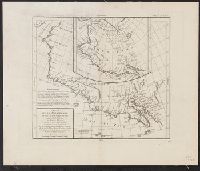
- Creator:
- Thompson, David, 1770-1857
- Published / Created:
- 19--?]
- Call Number:
- 73 1814
- Container / Volume:
- BRBL_00374
- Image Count:
- 1
- Resource Type:
- Maps, Atlases & Globes
- Found in:
- Beinecke Rare Book and Manuscript Library > Copy of a portion of map of the North-West territory of the Province of Canada : from actual survey during the years 1798 to 1812 / by David Thompson.
- Published / Created:
- 186-?]
- Call Number:
- 40gme M769 1864
- Container / Volume:
- BRBL_00230
- Image Count:
- 1
- Resource Type:
- Maps, Atlases & Globes
- Found in:
- Beinecke Rare Book and Manuscript Library > Corografia della Brianza col tracciamento della strada ferrata Monza-Lecco destinata ad attraversarla.
- Published / Created:
- 1850]
- Call Number:
- 40 F918 1850
- Container / Volume:
- BRBL_00208
- Image Count:
- 3
- Resource Type:
- Maps, Atlases & Globes
- Found in:
- Beinecke Rare Book and Manuscript Library > Corografia della Provincia del Friuli nel Regno Lombardo-Veneto : distinta ne' suoi distretti e comuni censuari formata in base delle mappe del nuovo censimento.
- Published / Created:
- 1850]
- Call Number:
- 40 B45 1850
- Container / Volume:
- BRBL_00205
- Image Count:
- 3
- Resource Type:
- Maps, Atlases & Globes
- Found in:
- Beinecke Rare Book and Manuscript Library > Corografia della Provincia di Bergamo nel Regno Lombardo-Veneto : distinta ne' suoi distretti e comuni censuari formata in base delle mappe del nuovo censimento.
- Published / Created:
- 1850]
- Call Number:
- 40 B75 1850
- Container / Volume:
- BRBL_00205
- Image Count:
- 2
- Resource Type:
- Maps, Atlases & Globes
- Found in:
- Beinecke Rare Book and Manuscript Library > Corografia della Provincia di Brescia nel Regno Lombardo-Veneto : distinta ne' suoi distretti e comuni censuari formata in base delle mappe del nuovo censimento.
- Published / Created:
- 1850]
- Call Number:
- 40 M59 1850
- Container / Volume:
- BRBL_00211
- Image Count:
- 1
- Resource Type:
- Maps, Atlases & Globes
- Found in:
- Beinecke Rare Book and Manuscript Library > Corografia della Provincia di Milano nel Regno Lombardo-Veneto : distinta ne' suoi distretti e comuni amministrativi e censuari secondo il vigente compartimento territoriale e formata in base delle Mappe dell'antico censimento Milanese.
- Published / Created:
- 1850]
- Call Number:
- 40 P13 1850
- Container / Volume:
- BRBL_00213
- Image Count:
- 1
- Resource Type:
- Maps, Atlases & Globes
- Found in:
- Beinecke Rare Book and Manuscript Library > Corografia della Provincia di Padua nel Regno Lombardo-Veneto : distinta ne' suoi distretti e comuni censuari formata in base delle mappe del nuovo censimento.
- Published / Created:
- 1850]
- Call Number:
- 40 P28 1850
- Container / Volume:
- BRBL_00214
- Image Count:
- 1
- Resource Type:
- Maps, Atlases & Globes
- Found in:
- Beinecke Rare Book and Manuscript Library > Corografia della Provincia di Pavia nel Regno Lombardo-Veneto : distinta ne' suoi distretti e comuni amministrativi e censuari secondo il vigente compartimento territoriale e formata in base delle Mappe dell'antico censimento Milanese.
- Published / Created:
- 1850]
- Call Number:
- 40 T729 1850
- Image Count:
- 1
- Resource Type:
- Maps, Atlases & Globes
- Found in:
- Beinecke Rare Book and Manuscript Library > Corografia della Provincia di Treviso nel Regno Lombardo-Veneto : distinta ne' suoi distretti e comuni censuari formata in base delle mappe del nuovo censimento.
- Published / Created:
- ca. 1850]
- Call Number:
- 40 V55 1850
- Image Count:
- 2
- Resource Type:
- Maps, Atlases & Globes
- Found in:
- Beinecke Rare Book and Manuscript Library > Corografia della Provincia di Venezia nel Regno Lombardo-Veneto : distinta ne' suoi distretti e comuni censuarj formata in base delle mappe del nuovo censimento.
- Published / Created:
- 1850]
- Call Number:
- 40 V59 1850
- Image Count:
- 2
- Resource Type:
- Maps, Atlases & Globes
- Found in:
- Beinecke Rare Book and Manuscript Library > Corografia della Provincia di Verona nel Regno Lombardo-Veneto : distinta ne' suoi distretti e comuni censuari formata in base delle mappe del nuovo censimento.
- Published / Created:
- 1850]
- Call Number:
- 40 V66 1850
- Image Count:
- 2
- Resource Type:
- Maps, Atlases & Globes
- Found in:
- Beinecke Rare Book and Manuscript Library > Corografia della Provincia di Vicenza nel Regno Lombardo-Veneto : distinta ne' suoi distretti e comuni censuari formata in base delle mappe del nuovo censimento.
- Published / Created:
- 1850?]
- Call Number:
- 40 B41 1850
- Container / Volume:
- BRBL_00204
- Image Count:
- 2
- Resource Type:
- Maps, Atlases & Globes
- Found in:
- Beinecke Rare Book and Manuscript Library > Corografia della provincia di Belluno nel Regno Lombardo Veneto : distinta ne' suoi distretti e comuni censuari, formata in base delle mappe del nuovo censimento.
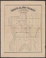
- Published / Created:
- 186-?]
- Call Number:
- 815ad C832 1860
- Container / Volume:
- BRBL_00561
- Image Count:
- 1
- Resource Type:
- Maps, Atlases & Globes
- Found in:
- Beinecke Rare Book and Manuscript Library > Council Bluffs vicinity / A. Cochran, dealer in lands, lots and land warrants.
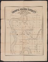
- Published / Created:
- 186-?]
- Call Number:
- 815ad C832 1860
- Container / Volume:
- BRBL_00561
- Image Count:
- 1
- Resource Type:
- Maps, Atlases & Globes
- Found in:
- Beinecke Rare Book and Manuscript Library > Council Bluffs vicinity / A. Cochran, dealer in lands, lots and land warrants.
- Published / Created:
- 1847 or 1848?]
- Call Number:
- 816fcm 1847
- Container / Volume:
- BRBL_00563
- Image Count:
- 1
- Resource Type:
- Maps, Atlases & Globes
- Found in:
- Beinecke Rare Book and Manuscript Library > Diagram of the state of Missouri.
- Published / Created:
- 1919
- Call Number:
- 45fac 1919
- Container / Volume:
- BRBL_00259
- Image Count:
- 1
- Resource Type:
- Maps, Atlases & Globes
- Found in:
- Beinecke Rare Book and Manuscript Library > Dobroudja.
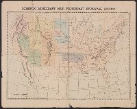
- Published / Created:
- 1874]
- Call Number:
- 75eha 1873
- Image Count:
- 1
- Resource Type:
- Maps, Atlases & Globes
- Found in:
- Beinecke Rare Book and Manuscript Library > Domestic missionary map, Protestant Episcopal Church.
- Published / Created:
- 1945?]
- Call Number:
- 48g 1945
- Container / Volume:
- BRBL_00264
- Image Count:
- 1
- Resource Type:
- Maps, Atlases & Globes
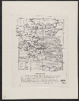
- Found in:
- Beinecke Rare Book and Manuscript Library > Economic map of Greece.
- Published / Created:
- 1910?]
- Call Number:
- 97 Ur8 1910
- Container / Volume:
- BRBL_00678
- Image Count:
- 1
- Resource Type:
- Maps, Atlases & Globes
- Found in:
- Beinecke Rare Book and Manuscript Library > El Urubamba y el Madre de Dios : con los varaderos que los ligan entre si y con el Puros / Luis M. Robledo, Agrimensor Civil.
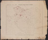
- Published / Created:
- 1910?]
- Call Number:
- 11hcf 1919B-6
- Container / Volume:
- BRBL_00010S
- Image Count:
- 1
- Resource Type:
- Maps, Atlases & Globes
- Found in:
- Beinecke Rare Book and Manuscript Library > Ethnography [of Caucasus Region].
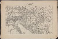
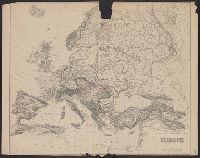
- Published / Created:
- 19--?]
- Call Number:
- 11hcf 1919B-17
- Container / Volume:
- BRBL_00010O
- Image Count:
- 2
- Resource Type:
- Maps, Atlases & Globes
- Found in:
- Beinecke Rare Book and Manuscript Library > Europe.
- Published / Created:
- 19--?]
- Call Number:
- 11hcf 1919B-17
- Container / Volume:
- BRBL_00010O
- Image Count:
- 1
- Resource Type:
- Maps, Atlases & Globes
- Found in:
- Beinecke Rare Book and Manuscript Library > Europe.
- Published / Created:
- 1918?]
- Call Number:
- 38hc 1918A Sep. folder
- Container / Volume:
- BRBL_00172
- Image Count:
- 1
- Resource Type:
- Maps, Atlases & Globes
- Found in:
- Beinecke Rare Book and Manuscript Library > Fernsprechleitungen der Schaltstellen.