Search
You Searched For
Search Results
- Creator:
- Germany. Heer. Generalstab
- Published / Created:
- 1940
- Call Number:
- 11hd 1942D-54
- Container / Volume:
- BRBL_00010ZE
- Image Count:
- 1
- Resource Type:
- Maps, Atlases & Globes
- Alternative Title:
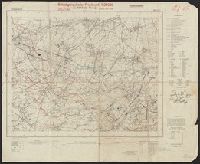
- Frankreich and St. Amand
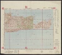
- Description:
- "Stand 29.3.1940, teilweise 7.4.1940." and Includes legend, list of abbreviations, chart of connecting sheets, and map showing political boundaires.
- Publisher:
- German General Staff,
- Subject (Geographic):
- France--Maps
- Found in:
- Beinecke Rare Book and Manuscript Library > Befestigungskarte Frankreich 1:25000 : St. Amand, Nr. 1-2, XXVI-5/1-2.
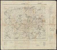
- Creator:
- Germany. Heer. Generalstab
- Published / Created:
- 1940
- Call Number:
- 11hd 1942D-54
- Container / Volume:
- BRBL_00010ZE
- Image Count:
- 1
- Resource Type:
- Maps, Atlases & Globes
- Alternative Title:
- Frankreich and St. Amand
- Description:
- "Stand 29.3.1940, teilweise 7.4.1940." and Includes legend, list of abbreviations, chart of connecting sheets, and map showing political boundaires.
- Publisher:
- German General Staff,
- Subject (Geographic):
- France--Maps
- Found in:
- Beinecke Rare Book and Manuscript Library > Befestigungskarte Frankreich 1:25000 : St. Amand, Nr. 1-2, XXVI-5/1-2.
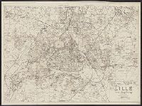
- Creator:
- Germany. Heer. Generalstab
- Published / Created:
- [1940?]
- Call Number:
- 38 L62 1940
- Container / Volume:
- BRBL_00158
- Image Count:
- 2
- Resource Type:
- Maps, Atlases & Globes
- Description:
- Shows: grid, street names, principal buildings, railways, legend of industral buildings and factories. and Street index on verso.
- Publisher:
- Generalstab des Heeres,
- Subject (Geographic):
- Lille (France)--Maps
- Found in:
- Beinecke Rare Book and Manuscript Library > Plan von Lille und Umgebung [cartographic material].