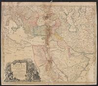
Tabula ex novissimus ad mentem de L'Islii, inprimis vero celeberrimi geographi Dni. I.M. Hasii, Prof. Vitemb. delineata a. 1737
Description:
"Cum privil. S.C.M. Grat.", Bar scales given in "milliaria Germanica," "milliaria Turcica," and "mill. Italica.", Relief shown pictorially., and Variant: without privilege statement in cartouche. Sheet measures 52.5 x 60.4 cm.
Publisher:
[Homann Erben,
Subject (Geographic):
Balkan Peninsula--Maps--Early works to 1800, Egypt--Maps--Early works to 1800, Libya--Maps--Early works to 1800, and Middle East--Maps--Early works to 1800
Subject (Name):
Hase, Johann Matthias, 1684-1742 and Homann Erben (Firm)
Mappe-monde qui représente les deux hemisphères savoir celui de l'orient et celui de l'occident, tirée des quatre cartes générales de feu M. le profess. Hasius, Planiglobii terrestris mappa vniversalis, and Schul-Atlas von zwantzig General- und Special-Lan
Description:
Appears in Homann heirs' Schul-atlas von zwantzig general-und special-land karten ... Cf. Phillips, no. 293., Imperfect: torn along fold, with no loss of text. Shee, Map colored to show distribution of religions., and Title in Latin and French; legend in German.
Publisher:
Homann Erben],
Subject (Name):
Hase, Johann Matthias, 1684-1742 and Homann Erben (Firm)
Subject (Topic):
Religion--Maps--Early works to 1800 and World maps--Early works to 1800