
You Searched For
« Previous
| 1 - 10 of 16 |
Next »
Search Results
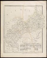
2.

- Creator:
- Homann Erben (Firm), cartographer, publisher.
- Published / Created:
- 1756
- Call Number:
- 755 1756Ea
- Image Count:
- 1
- Resource Type:
- Maps, Atlases & Globes
- Description:
- Appears in various eds. of Atlas geographicus maior., Includes German text relating to English and French territorial claims., Place names and descriptive notes in English., Prime meridian: Ferro and London., Relief shown pictorially., and Sheet measures 47.5 x 51 cm.
- Publisher:
- [Homann Erben],
- Subject (Geographic):
- North America--Maps--Early works to 1800. and United States--History--French and Indian War, 1755-1763--Maps--Early works to 1800.
- Subject (Name):
- Anville, Jean Baptiste Bourguignon d', 1697-1782. and Homann Erben (Firm). Atlas geographicus maior.
- Found in:
- Beinecke Rare Book and Manuscript Library > America Septentrionalis a Domino d'Anville in Galliis edita nunc in Anglia : coloniis in interiorem Virginiam deductis nec non Fluvii Ohio cursu aucta notisque geographicis et historicis illustrata / sumptibus Homannianorum Heredum.
3.

- Creator:
- Homann Erben (Firm)
- Published / Created:
- 1777
- Call Number:
- 755 1777B
- Container / Volume:
- BRBL_00431
- Image Count:
- 1
- Resource Type:
- Maps, Atlases & Globes
- Description:
- Appears in various eds. of Atlas geographicus maior., Includes German text relating to English and French territorial claims., Place names and descriptive notes in English., Prime meridian: Ferro and London., and Relief shown pictorially.
- Publisher:
- [s.n.],
- Subject (Geographic):
- North America--Maps--Early works to 1800. and United States--History--French and Indian War, 1755-1763--Maps--Early works to 1800.
- Subject (Name):
- Anville, Jean Baptiste Bourguignon d', 1697-1782. and Homann Erben (Firm). Atlas geographicus maior.
- Found in:
- Beinecke Rare Book and Manuscript Library > America Septentrionalis a Domino d'Anville in Galliis edita nunc in Anglia : coloniis in interiorem Virginiam deductis nec non Fluvii Ohio cursu aucta notisque geographicis et historicis illustrata et ad bellum praesentis temporis accomodata / sumptibus Homannianorum Heredum.
- Creator:
- Artaria & Co., author.
- Published / Created:
- [between 1910 an 1919?]
- Call Number:
- 424 1910
- Container / Volume:
- BRBL_00245
- Image Count:
- 2
- Resource Type:
- Maps, Atlases & Globes
- Alternative Title:
- Touristen-karten im Massstabe von 1:129,600 and Umgebung von Gmunden, Ischl, Hallstadt, Aufsee
- Description:
- Imperfect: all sheets but sheet 2 wanting. "Uebersichtsblatt zu R. Maschek's Touristenkarte" pasted on verso., Relief shown by hachures., and Title from panel pasted on verso.
- Publisher:
- Artaria & Comp.,
- Subject (Geographic):
- Austria--Maps.
- Found in:
- Beinecke Rare Book and Manuscript Library > Artaria's neueste Touristen-karten im Massstabe von 1:129,600.
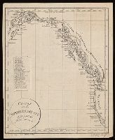
- Published / Created:
- [1814?]
- Call Number:
- BrSides 2018 138
- Image Count:
- 1
- Resource Type:
- Maps, Atlases & Globes
- Alternative Title:
- Allgemeine geographische Ephemeriden. Bd. VIII, 3 Stk.
- Description:
- Covers western coast of North America from northern California to Alaska., In lower left margin: F. d. Allg. Geogr. Ephem. VIII B. 3 Stk., Includes index of inlets, canals, and bays., Relief shown by hachures., and Watermark. Manuscript annotations on recto and verso.
- Publisher:
- [publisher not identified],
- Subject (Geographic):
- Northwest Coast of North America--Maps.
- Subject (Name):
- Vancouver, George, 1757-1798.
- Subject (Topic):
- Coasts--Canada--Maps.
- Found in:
- Beinecke Rare Book and Manuscript Library > Charte von der nordwestküste America's nach Vancouver.

- Creator:
- Oterschaden, Johannes, cartographer.
- Published / Created:
- 1879
- Call Number:
- 5 1550
- Container / Volume:
- BRBL_00271
- Image Count:
- 1
- Resource Type:
- Maps, Atlases & Globes
- Description:
- Reproduction of gores for a 17 cm globe.
- Publisher:
- [publisher not identified],
- Subject (Name):
- Austro-Hungarian Monarchy. Militär-Comité.
- Subject (Topic):
- Astronomy--Study and teaching--Early works to 1800--Facsimiles., Celestial globes--Early works to 1800--Facsimiles., Globes--Early works to 1800--Facsimiles., and Navigation--Study and teaching--Early works to 1800--Facsimiles
- Found in:
- Beinecke Rare Book and Manuscript Library > Globus aus der Mitte des XVI Jahrhunderts.

- Creator:
- Bibliographisches Institut Leipzig, cartographer.
- Published / Created:
- [between 1893 and 1901?]
- Call Number:
- BrSides Folio 2017 17
- Image Count:
- 1
- Resource Type:
- Maps, Atlases & Globes
- Alternative Title:
- Meyers Konversations-Lexikon.
- Description:
- "Meyers Konv.-Lexicon, 6. Aufl.", "Zum Artikel 'Guinea'.", Inset: Mittel-Deutschland in gleichem Masstab., and Relief shown by hachures and spot heights.
- Publisher:
- Bibliographisches Institut in Leipzig,
- Subject (Geographic):
- Africa, West--Maps.
- Subject (Name):
- Meyer, Hermann Julius, 1826-1909.
- Found in:
- Beinecke Rare Book and Manuscript Library > Ober-Guinea und West-Sudan.

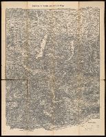
- Creator:
- Kiepert, Heinrich, 1818-1899, cartographer.
- Published / Created:
- 1875
- Call Number:
- BrSides Double Folio 2017 7
- Image Count:
- 1
- Resource Type:
- Maps, Atlases & Globes
- Description:
- From Hugo Strumm's Der Russische feldzug nach Chiwa (1875)., In upper left corner, "Zu Lt. Stumm's Russ. Feldzug nach Chiwa.", In upper right corner, "Taf. III (zum Schlufs des II. Theils.)", and Relief shown by hachures.
- Publisher:
- [Mittler],
- Subject (Geographic):
- Asia, Central--Maps.
- Subject (Name):
- Kraatz, Leopold, lithographer. and Stumm, Hugo. Russische feldzug nach Chiwa.
- Subject (Topic):
- Russo-Khivan Expedition, 1873--Maps.
- Found in:
- Beinecke Rare Book and Manuscript Library > Operations- und marschrouten-karte zu Lt. H. Stumm's Russischer Feldzug nach Chiwa 1873 / vorzüglich nach Russischen Originalkarten zusammengestellt von H. Kiepert.

- Creator:
- Münster, Sebastian, 1489-1552.
- Published / Created:
- 1588]
- Call Number:
- 13 1588
- Image Count:
- 2
- Resource Type:
- Maps, Atlases & Globes
- Description:
- Covers the eastern hemisphere above 25⁰ S., Imperfect: chipped along edges, with no loss of text. Cross collection no. 13., Includes ill., Relief shown pictorially., and Text and diagram titled "Die Nammen und Gegne der Wind" on verso, with signature mark: ij.
- Publisher:
- H. Petri,
- Subject (Geographic):
- Eastern Hemisphere--Maps--Early works to 1800.
- Subject (Name):
- Petri, Heinrich, 1508-1579.
- Found in:
- Beinecke Rare Book and Manuscript Library > Ptolemeisch general Tafel : die halbe Kugel der Weltbegreiffende.
10.

- Creator:
- Schenk, Peter, 1660-1718 or 1719.
- Published / Created:
- 1706?]
- Call Number:
- 1973 Folio 18
- Image Count:
- 1
- Resource Type:
- Maps, Atlases & Globes
- Alternative Title:
- Sacrum Imperium Romano-Germanicum oder Teutschland mit seinen angrantzenden Konigreichen und Provincien and Teutschland mit seinen angrantzenden Konigreichen und Provincien
- Description:
- Backed with paper. Ms. no. "15" in upper right-hand corner. Sheet measures 53.6 x 62.6 cm. No. 15 of 87 maps bound together., Bar scales given in "teutsche Meilen" and "französiche Meilen"., and Prime meridian: Ferro.
- Publisher:
- [Peter Schenk,
- Subject (Geographic):
- Europe, Central--Maps--Early works to 1800. and Holy Roman Empire--Maps--Early works to 1800.
- Found in:
- Beinecke Rare Book and Manuscript Library > S. Imperium Romano-Germanicum oder Teutschland mit seinen angrantzenden Konigreichen und Provincien [cartographic material] / aussgegeben durch Petrus Schenk ; mit Privilegie derer H. H. Staten General des Vereinigten Niederland.