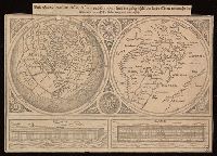
Universaltafel des situs Asiae, Africae und Europae, samt der gelegenhäit des lands Eden, wie auch eine delineatio der arch Noe bäides im grund und auftitz
Description:
Caption title., Includes two images of Noah's ark., One partial hemisphere map of Europe, Africa, and Asia and one map of the Biblical Middle East., and Relief shown pictorially.
Publisher:
[publisher not identified],
Subject (Geographic):
Middle East--Maps--Early works to 1800. and Northern Hemisphere--Maps--Early works to 1800.
Subject (Topic):
Bible.--Old Testament--Geography--Maps--Early works to 1800.
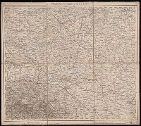
Copy 3: Imperfect: all sheets but C2, C3, and D3 wanting., Covers Europe from western France to eastern Russia, and from the North Sea to the Aegean Sea., and Relief shown by hachures and spot heights.
Covers Europe from western France to eastern Russia, and from the North Sea to the Aegean Sea., Includes sheet index., Introductory sheets include title, location map, glossary, and legend., Pronunciation guide and abbreviations in 8 languages., Relief shown by hachures and spot heights., and Sheet title and scale bars affixed to verso. Only sheet F.6 verso digitized as reference.
Copy 2: Imperfect: all sheets but C1, C2, D1, D2, E1 and E2 wanting., Covers Europe from western France to eastern Russia, and from the North Sea to the Aegean Sea., and Relief shown by hachures and spot heights.
"Photolitho: Berliner Lithographisches Institut, Berlin W 35". and 307 1942: Includes index map (using "Europe and the Near East, compiled and drawn in the Cartographic Section of the National Geographic Society" as base map).