Skip to search
Skip to main content
Skip to first result
Search
You Searched For
Resource Type
Maps, Atlases & Globes
New Search
Search Results
Creator:
Published / Created:
1922
Call Number:
848 In5 1922
Container / Volume:
BRBL_00633
Image Count:
1
Resource Type:
Maps, Atlases & Globes
Alternative Title:
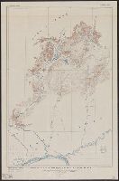
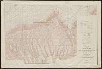
Iniskin-Chinitna Peninsula, Cook Inlet region, Alaska
Description:
Includes inset location map., Relief shown by contours and spot heights., and Surveyed in 1921.
Publisher:
Geological Survey,
Subject (Geographic):
Chinitna Bay Region (Alaska)--Maps, Cook Inlet Region (Alaska)--Maps, and Iniskin Peninsula (Alaska)--Maps
Subject (Name):
Brooks, Alfred H. (Alfred Hulse), 1871-1924, FitzGerald, Gerald Arthur, 1899-, and McKinley, C. P
Found in:
Beinecke Rare Book and Manuscript Library > Topographic map of Iniskin-Chinitna Peninsula, Cook Inlet region, Alaska / United States Department of the Interior Geological Survey ; Alfred H. Brooks, geologist in charge of division ; topography by C.P. McKinley and Gerald Fitz-Gerald.
Creator:
Published / Created:
1915
Call Number:
834 M56 1915
Container / Volume:
BRBL_00589
Image Count:
1
Resource Type:
Maps, Atlases & Globes
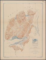
Description:
"R.B. Marshall, chief geographer. Sledge Tatum, geographer in charge. Topography by R.W. Berry and C.A. Ecklund. Control by C.F. Urquhart, M.R. McDanal, and R.M. Copeland.", "Surveyed in 1910-11.", and Includes inset showing "Railroad lines leading to Mesa Verde National Park."
Publisher:
U.S. Geological Survey,
Subject (Geographic):
Mesa Verde National Park (Colo.)--Maps
Subject (Name):
Berry, R. W, Copeland, R. M, Ecklund, C. A, Marshall, R. B. (Robert Bradford), 1867-1949, McDanal, M. R, Tatum, Sledge, and Urquhart, C. F
Found in:
Beinecke Rare Book and Manuscript Library > Topographic map of Mesa Verde National Park, Montezuma County, Colorado.
Creator:
Published / Created:
1907
Call Number:
848 So47 1909
Container / Volume:
BRBL_00634
Image Count:
1
Resource Type:
Maps, Atlases & Globes
Alternative Title:
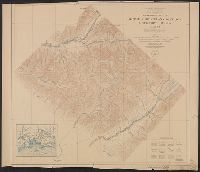
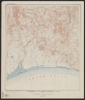
Solomon quadrangle, Alaska and Solomon, Alaska
Description:
Bulletin 433 Plate III., Contour interval 25 feet., and Surveyed in 1905.
Publisher:
The Survey,
Subject (Geographic):
Solomon River Valley (Alaska)--aps
Subject (Name):
U.S. Coast and Geodetic Survey
Found in:
Beinecke Rare Book and Manuscript Library > Topographic map of Solomon quadrangle, Alaska.
Creator:
Published / Created:
1910]
Call Number:
28 T11 1909
Container / Volume:
BRBL_00024
Image Count:
1
Resource Type:
Maps, Atlases & Globes
Alternative Title:
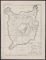
Geological reconnaissance of southwestern Luzon.
Description:
"Adams: Reconnaissance of southwestern Luzon." and From: Philippine Journal of Science, vol. v, no. 2.
Publisher:
Bureau of Science,
Subject (Geographic):
Taal, Mount (Philippines)--Maps
Subject (Name):
Adams, George I. (George Irving), 1870-1932 and Philippines. Bureau of Science
Found in:
Beinecke Rare Book and Manuscript Library > Topographic map of Taal Island showing Taal volcano / S.B. Coleman, surveyor.
Creator:
Published / Created:
1907?]
Call Number:
795 C126 1907
Container / Volume:
BRBL_00522
Image Count:
1
Resource Type:
Maps, Atlases & Globes
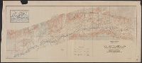
Description:
"Levels: L. Reinecke, F.L. Whitney, L.K. Wood. Traverse: G.D. Harris, E.B. Hopkins, F.L. Whitney. Stream detail: A.G. Hammar. Topography: G.D. Harris, E.B. Hopkins. Geodetic and hypsometric location of B.M's determined by cooperation with United States Geologic Survey, L.E. Tucker, E.L. McNair."
Publisher:
State Geological Survey of Louisiana?,
Subject (Geographic):
Acadia Parish (La.)--Maps and Calcasieu Parish (La.)--Maps
Subject (Name):
Matthews-Northrup Works
Found in:
Beinecke Rare Book and Manuscript Library > Topographic map of a portion of Calcasieu & Acadia parishes : townships 9 & 10 S, ranges 1 2 & 3 W / State Geological Survey of Louisiana.
Branch:v1.61.6 ,Deployed:2024-06-12T09:55:36-04:00