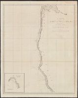
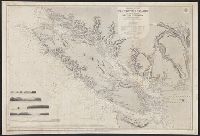
From: Vancouver's A voyage of discovery to the North Pacific Ocean and round the world. London, 1798., In top right margin: 5., Insets: Entrance of Columbia River -- Gray's Harbour -- Port Discovery., and Relief shown pictorially and by hachures. Depths shown by soundings.
Publisher:
J. Edwards & G. Robinson,
Subject (Geographic):
British Columbia--Maps--Early works to 1800 and Washington (State)--Maps--Early works to 1800
Subject (Name):
Arnold, Robert M.--Ownership, Baker, Joseph, 1768-1817, Edwards, James, 1757-1816, Robinson, G. G. (George G.), and Vancouver, George, 1757-1798. Voyage of discovery to the North Pacific Ocean and round the world. 1
Subject (Topic):
Coasts--British Columbia--Maps--Early works to 1800 and Coasts--Washington (State)--Maps--Early works to 1800
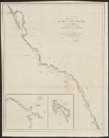
From: Vancouver's A voyage of discovery to the North Pacific Ocean and round the world. London, 1798., In top right margin: 7., Includes inset of "A survey of Port Stewart.", and Relief shown pictorially and by hachures. Depths shown by soundings.
Publisher:
J. Edwards & G. Robinson,
Subject (Geographic):
Alaska--Maps--Early works to 1800 and British Columbia--Maps--Early works to 1800
Subject (Name):
Arnold, Robert M.--Ownership, Baker, Joseph, 1768-1817, Edwards, James, 1757-1816, Robinson, G. G. (George G.), and Vancouver, George, 1757-1798. Voyage of discovery to the North Pacific Ocean and round the world. 1
Subject (Topic):
Coasts--Alaska--Early works to 1800 and Coasts--British Columbia--Maps--Early works to 1800
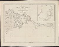
From: Vancouver's A voyage of discovery to the North Pacific Ocean and round the world. London, 1798., In top right margin: Plate 3., Includes inset of "Bay of Trinidad.", and Relief shown pictorially and by hachures. Depths shown by soundings.
Publisher:
J. Edwards & G. Robinson,
Subject (Geographic):
California--Maps--Early works to 1800 and Oregon--Maps--Early works to 1800
Subject (Name):
Arnold, Robert M.--Ownership, Baker, Benjamin, Baker, Joseph, 1768-1817, Edwards, James, 1757-1816, Robinson, G. G. (George G.), and Vancouver, George, 1757-1798. Voyage of discovery to the North Pacific
Subject (Topic):
Coasts--California--Maps--Early works to 1800 and Coasts--Oregon--Maps--Early works to 1800
From: Vancouver's A voyage of discovery to the North Pacific Ocean and round the world. London, 1798., In top right margin: 14., and Relief shown pictorially and by hachures.
Publisher:
J. Edwards & G. Robinson,
Subject (Geographic):
Alaska--Maps--Early works to 1800 and Northwest Coast of North America--Maps--Early works to 1800
Subject (Name):
Arnold, Robert M.--Ownership, Edwards, James, 1757-1816, Roberts, Edward, Robinson, G. G. (George G.), and Vancouver, George, 1757-1798. Voyage of discovery to the North Pacific Ocean and round the world. 1798
From: Vancouver's A voyage of discovery to the North Pacific Ocean and round the world. London, 1798., In top right margin: No. 8., Insets: Entrance of Port Sn. Francisco -- Port Sn. Diego., and Relief shown pictorially and by hachures. Depths shown by soundings.
Publisher:
J. Edwards & G. Robinson,
Subject (Geographic):
California--Maps--Early works to 1800
Subject (Name):
Arnold, Robert M.--Ownership, Baker, Joseph, 1768-1817, Edwards, James, 1757-1816, Foot, T. (Thomas), Robinson, G. G. (George G.), and Vancouver, George, 1757-1798. Voyage of discovery to the North Pacifi
From: Vancouver's A voyage of discovery to the North Pacific Ocean and round the world. London, 1798., In top right margin: No. 11., Includes inset of "A survey of Port Chalmers.", and Relief shown pictorially and by hachures. Depths shown by soundings.
Publisher:
J. Edwards & G. Robinson,
Subject (Geographic):
Alaska--Map--Early works to 1800
Subject (Name):
Arnold, Robert M.--Ownership, Baker, Joseph, 1768-1817, Edwards, James, 1757-1816, Foot, T. (Thomas), Robinson, G. G. (George G.), and Vancouver, George, 1757-1798. Voyage of discovery to the North Pacifi
From: Vancouver's A voyage of discovery to the North Pacific Ocean and round the world. London, 1798., Includes inset of "A survey of Port Chatham.", and Relief shown pictorially and by hachures. Depths shown by soundings.
Publisher:
J. Edwards & G. Robinson,
Subject (Geographic):
Alaska--Maps--Early works to 1800
Subject (Name):
Arnold, Robert M.--Ownership, Baker, Joseph, 1768-1817, Edwards, James, 1757-1816, Neele, Samuel John, 1758-1824, Robinson, G. G. (George G.), and Vancouver, George, 1757-1798. Voyage of discovery to the
From: Vancouver's A voyage of discovery to the North Pacific Ocean and round the world. London, 1798., In top right margin: No. 12., Insets: Entrance into Cross Sound -- A survey of Port Conclusion -- A survey of Port Protection., and Relief shown pictorially and by hachures.
Publisher:
J. Edwards & G. Robinson,
Subject (Geographic):
Alaska--Maps--Early works to 1800
Subject (Name):
Arnold, Robert M.--Ownership, Baker, Joseph, 1768-1817, Edwards, James, 1757-1816, Foot, T. (Thomas), Robinson, G. G. (George G.), and Vancouver, George, 1757-1798. Voyage of discovery to the North Pacifi
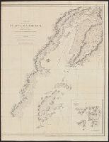
"Juan de Fuca Strait from Capt. Henry Kellett's survey of 1847. Shores of Washington Territory from the United States Coast Survey.", At head of title: North America, west coast., Includes 6 coastal views., and Relief shown by hachures and spot heights. Depths s
Publisher:
The Admiralty,
Subject (Geographic):
Vancouver Island (B.C.)--Maps
Subject (Name):
Arnold, Robert M.--Ownership, Davies & Powell, Mayne, R. C, Powell, E. J, and Richards, G. H. (George Henry)
Subject (Topic):
Coasts--British Columbia--Maps and Coasts--Washington (State)--Maps