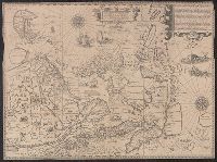
Exacta et accurata delineatis cum orarum maritimarum tum etjam locorum terrestrium and Waarachtige wtworpinghe ofte afbeeldinge van alle dje custen end landen
Description:
Appears in the author's Itinerario. 1596., Backed with paper., Has watermark., Includes ill., Latin and Dutch., Oriented with north to the left., and Relief shown pictorially.
Publisher:
C. Claesz,
Subject (Geographic):
Southeast Asia--Maps--Early works to 1800
Subject (Name):
Langren, Arnold Florent van, 1580-1644, Langren, Henricus F. ab (Henricus Florentius), ca. 1574-1648, engraver, Linschoten, Jan Huygen van, 1563-1611, and Linschoten, Jan Huygen van, 1563-1611. Itinerario, voyage ofte schipvae
Subject (Topic):
Nautical charts--South China Sea--Early works to 1800 and Nautical charts--Southeast Asia--Early works to 1800
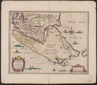
Bar scales in "Miliaria Germanica communia" and "Miliaria Gallica communia.", From Jan Jansson and Henrik Hondius's Atlas novus ... Amstelodami : Apud Ionnem Ianssonium & Henricum Hondium, 1638., In Latin on verso, with caption title "Freti Magellanici et freti le Marii descriptio" and signature 5F., and Relief shown pictorially.
Publisher:
Hendrik Hondius,
Subject (Geographic):
Magellan, Strait of (Chile and Argentina)--Maps--Early works to 1800
Subject (Name):
Hondius, Hendrik, 1597-1651. Atlas novus and Jansson, Jan, 1588-1664. Atlas novus
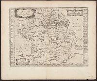
Atlas novus. and Gallia vetus ad Julij Caesaris commentaria
Description:
Latin text on recto; Dutch text on verso., Lower left corner: "Amstelodami apud Ioannem Ianβonium.", Published in Dutch editions of Jansson's Atlas novus (Dutch title: Nieuwen atlas, ofte vveerelts-beschrijvinge), vol. 6, ca. 1662, and Relief shown pictorially.
Publisher:
Jan Jansson,
Subject (Geographic):
France--History--To 987--Maps--Early works to 1800 and Gaul--Maps--Early works to 1800
From Willem and Joan Blaeu's Theatrum orbis terrarum. Amsterdami : Apud Guiljelmum et Iohannem Blaeu, 1635., Signature on verso: I., and Title on verso: Granata & Murcia.
Publisher:
Blaeu,
Subject (Geographic):
Granada (Spain : Province)--Maps--Early works to 1800 and Murcia (Spain : Region)--Maps--Early works to 1800
Appeared in Valk and Schenk's Atlantis sylloge compendiosa, ca. 1702., Backed with paper. Ms. no. "29" in upper left-hand corner. Sheet measures 53.5 x 62.5 cm. No. 29 of 87 maps bound together., Includes five bar scales., Prime meridian: Ferro., Relief shown pictorially., and Watermark.
Publisher:
Gerard Valk,
Subject (Geographic):
Switzerland--Maps--Early works to 1800.
Subject (Name):
Schenk, Peter, 1660-1718 or 1719. Atlantis sylloge compendiosa. and Valck, G. (Gerard), 1651 or 1652-1726. Atlantis sylloge compendiosa.
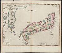
"Cum privilegio Sacrae Caesare Majestatis & ordinum Belgicae Foederatae"., Appeared in various eds. of Martino Martini's Novus atlas Sinensis (published by Blaeu)., Bar scales given in "milliaria Iaponica" and, and With watermark. Sheet measures 51.5 x 59.7 cm.
Publisher:
Joan Blaeu,
Subject (Geographic):
Japan--Maps--Early works to 1800 and Korea--Maps--Early works to 1800
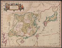
"Cum privilegio Sacrae Caesareae Majestatis, & ordinum Belgicae Foederatae.", Appears in Novus atlas sinensis. 1655., Covers China and Japan., Includes ornamental cartouche with gilt., and Relief shown pictorially.
Publisher:
J. Blaeu,
Subject (Geographic):
China--Maps--Early works to 1800 and Japan--Maps--Early works to 1800
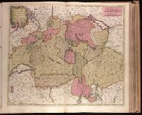
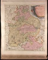
Backed with paper. Ms. no. "27" in upper right-hand corner. Sheet measures 52.7 x 53.7 cm. No. 27 of 87 maps bound together., Bar scales given in "milliaria Germanica" and "mill. Gallica"., Prime meridian: Ferro., and Relief shown pictorially.
Publisher:
Peter Schenk,
Subject (Geographic):
Austria--Maps--Early works to 1800. and Bavaria (Germany)--Maps--Early works to 1800.