"Avec privilege.", Appeared in Anville's Atlas général., Imperfect: Mutilated wih loss of text. Hand colored. Sheets joined. Manuscript note in unidentified hand., Includes seven bar scales., and Relief shown pictorially.
Publisher:
Chez l'Auteur aux Galerie du Louvre,
Subject (Geographic):
Asia--Maps--Early works to 1800.
Subject (Name):
Anville, Jean Baptiste Bourguignon d', 1697-1782. Atlas général. and Haye, G. de la
Imperfect: torn along left fold, with no loss of text. Backed with paper. Ms. no. "11" in upper right-hand corner. Sheet measures 53.5 x 61.6 cm. No. 10 of 87 maps bound together. and Relief shown pictorially.
Publisher:
Chez Pierre Husson,
Subject (Geographic):
Stralsund (Germany)--Maps.
Subject (Topic):
Northern War, 1700-1721--Campaigns--Germany--Mecklenburg (Region) and Northern War, 1700-1721--Maps--Early works to 1800.
Carte generale de la Tartarie chinoise et des royaumes de Corée et de Iapan
Description:
French alternate title only., Imperfect: western sheet (with cartouche) wanting. Sheet measures 54 x 54 cm, with watermark., Includes text and ill., and Relief shown pictorially.
Publisher:
Curis Homannianorum Heredum,
Subject (Geographic):
Chine--Divisions politiques et administratives--Cartes--Ouvrages avant 1800. and Manchuria (China)--Maps--Early works to 1800.
Subject (Name):
Anville, Jean Baptiste Bourguignon d', 1697-1782., Du Halde, J.-B. (Jean-Baptiste), 1674-1743., Gerbillon, Jean-François, 1654-1707., Homann Erben (Firm), and Mayer, Tobias, 1723-1762.
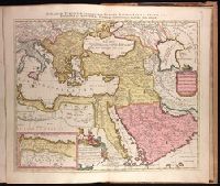
Imperium Turcicum, complectens Europae, Asiae et Africae, Arabiae que regiones ac provincias plurimas, industria et labore Petr. Schenck
Description:
Appeared in Peter Schenk's Atlas contractus., Backed with paper. Ms. no. "91" in upper right-hand corner. Sheet measures 53.6 x 62.5 cm. No. 83 of 87 maps bound together., Includes six bar scales., Inset map [partially obscuring title in cartouche] is continuation of the North African coastline., Prime meridian: Ferro., and Relief shown pictorially.
Publisher:
P. Schenck, avec privil,
Subject (Geographic):
Africa, North--Maps--Early works to 1800., Europe, Southern--Maps--Early works to 1800., Middle East--Maps--Early works to 1800., and Turkey--Maps--Early works to 1800.
Subject (Name):
Schenk, Peter, 1660-1718 or 1719. Atlas contractus.