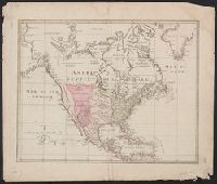
Differs in coloring from Yale's other copy, with Latin America and land west of the Mississippi washed in pink; and height approx. 3 mm. less than other copy., Relief shown pictorially., and Shows "Republique des XIII provinces"; "Nouveau Mexique" extending to
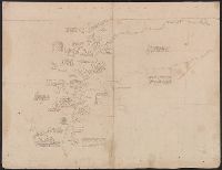
Includes identification of locations and text in ink. Latitude and longitude figures appear in ink and pencil along upper and left margins although they do not correspond to modern measurements., Includes two significant blocks of text: "La Rivière Ohio..." (above) and "L'embouchúre du fleuve Missisipi, que M. de La Salle a descendu le premier iusques a la Mer, ou il arrive le 7 Avril 1682 avec le P. Zenobe Recolles missionaire...du nom de Rio Escondido.", Relief shown pictorially., The map is illustrated in ink and wash with the following vignettes counterclockwide from bottom: native peoples building a boat from felled trees; a roofed structure; a grove of trees; beds; native peoples flipping over an alligator with a pole, and then attacking it with clubs and arrows near a roofed structure; and a small herd of buffalo, labelled "Pisikious ou Boeffs Sauvagees.", The Mississippi River is labelled "Fleuve Missisipi ou Colbert.", The Mississippi River is shown flowing into the western coast of the Gulf of Mexico. The Rivière Ouabache (Wabash) is shown separated from the Ohio., and This map was probably used by Coronelli in his preparation of an improved terrestrial globe for presentation to Louis XIV by Cardinal César d'Estrées, ca. 1683, see the text of the note on the right of the map, "La Rivière Ohio ou Belle rivière ainsi appelée pour sa beauté..." which also appears on Coronelli's globe (see also Pelletier reference).
Subject (Geographic):
Mississippi River Valley--Maps, Manuscript--Early works to 1800 and United States--Maps, Manuscript--Early works to 1800
Subject (Name):
Coronelli, Vincenzo, 1650-1718
Subject (Topic):
Indians of North America--Maps, Manuscript--Early works to 1800
All volumes bound to match 1973 Folio 72. Factitious collection of about 549 maps taken from the atlases of the 17th and the beginning of the 18th cent., put together with the title "Atlas" and bound in 6 volumes. These volumes originally bore the imprint: Amstelaedamii apvd Reiniervm & Josvam Ottens. Over these words on the title-pages of v. 1-2, 4-6 is the name of Henrik de Leth who painted them. Volume 3 has only the erased imprint of Ottens., For fuller description see Phillips 3448 and C. Koeman's Atlantes Neerlandici, bibliography of terrestrial, maritime and celestial atlases and pilot books, published in the Netherlands up to 1800, Amsterdam c1967-71, v. 2, p. 63-83., and Maps by P. Schenck and son, G. Valck, F. de Wit, N. Visscher and others.
Publisher:
chez J. Covens & C. Mortier,
Subject (Geographic):
Denmark --Maps --Early works to 1800
Subject (Name):
Reiner et Josua Ottens (Firm), Schenk, Peter, 1660-1718 or 1719., and Valck, G. (Gerard), 1651 or 1652-1726.
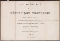
Carte topographique de France de l'Etat-Major., Etat-Major carte de France., and Etat-Major nouvelle carte de France.
Description:
Imperfect: sheets 39 and 126-150 wanting; copies of sheets 131, 132, 141-144 and copy 2 of sheet 214 trimmed to neat line. Sheets dissected and m, Multiple copies of some sheets., and Some sheets imprinted "levée par les Officiers du Corps Royal d'Etat-Major."
Carte topographique de France de l'Etat-Major., Etat-Major carte de France., and Etat-Major nouvelle carte de France.
Description:
Imperfect: sheets 39 and 126-150 wanting; copies of sheets 131, 132,, Multiple copies of some sheets., Sheet 219. Alby includes panel title "Etat-Major nouvelle carte de France"., and Some sheets imprinted "levée par les Officiers du Corps Royal d'Etat-Major."
Maps numbered in manuscript 1 to 97; wanting 2, 42, 45, 51, 52, 74, 85, 89, 92 and 93., Some maps dated 1704-1717, others without date., Some maps first published in J. van Keulen's De nieuwe groote lichtende zee-fackel and G. van Keulen's De groote nieuwe vermeerderde zee-atlas., Title devised by cataloger., and With engraved title-page: "Gedruckt tot Amsterdam bÿ Ioannes van Keulen, boeck zee-kaardt verkooper en graad-boogh maker aande oost zÿde vande Nieuwebrug inde gekroonde Lootsman. Met previlegie ... 1718"; engraved title-page has same illustration as J. van Keulen's De groote nieuwe vermeerderde zee-atlas ofte water-werelt ... 1681.
Publisher:
s.n.,
Subject (Name):
Keulen, Gerard van., Keulen, Johannes van, 1654-1715. Groote nieuwe vermeerderde zee-atlas ofte water-waereld., Keulen, Johannes van, 1654-1715. Nieuwe groote lichtende zee-fakkel., Schenk, Peter, 1660-1718 or 1719., and Valck, G. (Gerard), 1651 or 1652-1726.
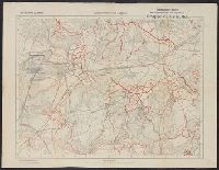
"Bearbeitet und gedruckt im Februar 1918.", "Lithographie und Druck von Gruppen Kartenstelle II.", "Stand vom 12.April18.", French and German., and Includes legend.
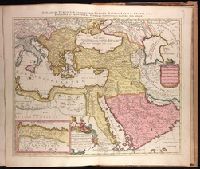
Imperium Turcicum, complectens Europae, Asiae et Africae, Arabiae que regiones ac provincias plurimas, industria et labore Petr. Schenck
Description:
Appeared in Peter Schenk's Atlas contractus., Backed with paper. Ms. no. "91" in upper right-hand corner. Sheet measures 53.6 x 62.5 cm. No. 83 of 87 maps bound together., Includes six bar scales., Inset map [partially obscuring title in cartouche] is continuation of the North African coastline., Prime meridian: Ferro., and Relief shown pictorially.
Publisher:
P. Schenck, avec privil,
Subject (Geographic):
Africa, North--Maps--Early works to 1800., Europe, Southern--Maps--Early works to 1800., Middle East--Maps--Early works to 1800., and Turkey--Maps--Early works to 1800.
Subject (Name):
Schenk, Peter, 1660-1718 or 1719. Atlas contractus.