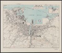
Great Britain. War Office. General Staff. Geographical Section
Published / Created:
1943
Call Number:
38 C42 1943
Container / Volume:
BRBL_00156
Image Count:
1
Resource Type:
Maps, Atlases & Globes
Alternative Title:
Geographical Section, General Staff ; no. 4234 and GSGS (Series) ; 4234.
Description:
"3rd edition 1943.", "Air photographs have been used in the production of this plan.", "Contours at 10 metres interval.", "N4937.4-W134.5/2.5x5.", "Published by War Office, 1941.", Important streets and buildings are named., and Includes inset map: Environs of Cher
Publisher:
[Printed by] Army Map Service, U.S. Army, and Published by War Office ;
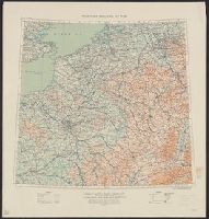
Great Britain. War Office. General Staff. Geographical Section
Published / Created:
1915
Call Number:
11hc 1915E
Image Count:
1
Resource Type:
Maps, Atlases & Globes
Alternative Title:
Geographical Section General Staff ; 3024 and GSGS (Series) ; 3024.
Description:
Ms. notes outside bottom right margin: "Based on Paris M31, Frankfurt M32, Lyons L31 & Milan L32, of Europe 1:1,000,000.", Relief shown as contours and gradient tints., and Shows: international boundaries, relative importance of towns, railways (2 categories),
Publisher:
G.S.G.S.,
Subject (Geographic):
Belgium--Maps and France--Maps
Subject (Topic):
World War, 1914-1918--Belgium--Maps and World War, 1914-1918--France--Maps