"I. Senex sculpt.", "To the right honorable Charles Boyle, Earl of Orrery and Baron of Broghil in the kingdom of, Longitude referenced from London., and Ms. no. on verso: 13. Rebacked on paper. Sheet measures 69 x 94 cm. Cross Collection no. 88.
Publisher:
s.n.,
Subject (Geographic):
France--Maps--Early works to 1800
Subject (Name):
Orrery, Charles Boyle, Earl of, 1674-1731, dedicatee and Senex, John, d. 1740. New general atlas
United States. Office of Strategic Services. Research and Analysis Branch
Published / Created:
1943
Call Number:
38gme 1943B
Container / Volume:
BRBL_00171
Image Count:
1
Resource Type:
Maps, Atlases & Globes
Description:
"Map no. 2318 (supersedes map no. 641); revised 14 July 1943.", Inset: Paris and environs., and Shows: international boundaries, railways (4 categories).
Great Britain. War Office. General Staff. Geographical Section
Published / Created:
1943
Call Number:
11hd 1942D-40
Container / Volume:
BRBL_00010ZD
Image Count:
1
Resource Type:
Maps, Atlases & Globes
Alternative Title:
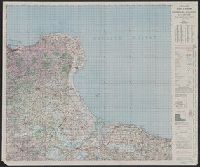
Cherbourg-Valognes, G.S, G.S. (Series) ; 4249, and Geographic Section, General Staff (Series) ; 4249
Description:
"50,000/6/44 E.", "French 1:80,000 sheets 17 N.W., S.W.; 28 N.W., N.E.", and Includes glossary, reference table, index to adjoining sheets, incidence of grid letters, and reliability diagram.
Great Britain. War Office. General Staff. Geographical Section
Published / Created:
1943
Call Number:
11hd 1942D-38
Container / Volume:
BRBL_00010ZD
Image Count:
1
Resource Type:
Maps, Atlases & Globes
Alternative Title:
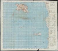
G.S, G.S. (Series) ; 4249, Geographic Section, General Staff (Series) ; 4249, and Jersey-Iles Chausey
Description:
"French 1:80,000 sheets 27 S.E.; 43 E.; & part of 27 N.E. and 1:31,680 Map of Jersey." and Includes glossary, reference table, index to adjoining sheets, incidence of grid letters, and reliability diagram.
Great Britain. War Office. General Staff. Geographical Section
Published / Created:
1943
Call Number:
11hd 1942D-38
Container / Volume:
BRBL_00010ZD
Image Count:
1
Resource Type:
Maps, Atlases & Globes
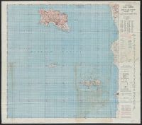
Alternative Title:
G.S, G.S. (Series) ; 4249, Geographic Section, General Staff (Series) ; 4249, and Jersey-Iles Chausey
Description:
"French 1:80,000 sheets 27 S.E.; 43 E.; & part of 27 N.E. and 1:31,680 Map of Jersey." and Includes glossary, reference table, index to adjoining sheets, incidence of grid letters, and reliability diagram.
Great Britain. War Office. General Staff. Geographical Section
Published / Created:
1943
Call Number:
11hd 1942D-38
Container / Volume:
BRBL_00010ZD
Image Count:
1
Resource Type:
Maps, Atlases & Globes
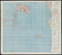
Alternative Title:
G.S, G.S. (Series) ; 4249, Geographic Section, General Staff (Series) ; 4249, and Jersey-Iles Chausey
Description:
"French 1:80,000 sheets 27 S.E.; 43 E.; & part of 27 N.E. and 1:31,680 Map of Jersey." and Includes glossary, reference table, index to adjoining sheets, incidence of grid letters, and reliability diagram.
Great Britain. War Office. General Staff. Geographical Section
Published / Created:
1943
Call Number:
11hd 1942D-38
Container / Volume:
BRBL_00010ZD
Image Count:
1
Resource Type:
Maps, Atlases & Globes
Alternative Title:
G.S, G.S. (Series) ; 4249, Geographic Section, General Staff (Series) ; 4249, and Jersey-Iles Chausey
Description:
"French 1:80,000 sheets 27 S.E.; 43 E.; & part of 27 N.E. and 1:31,680 Map of Jersey." and Includes glossary, reference table, index to adjoining sheets, incidence of grid letters, and reliability diagram.
Great Britain. War Office. General Staff. Geographical Section
Published / Created:
1943
Call Number:
11hd 1942D-39
Container / Volume:
BRBL_00010ZD
Image Count:
1
Resource Type:
Maps, Atlases & Globes
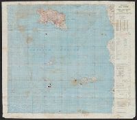
Alternative Title:
G.S, G.S. (Series) ; 4249, Geographic Section, General Staff (Series) ; 4249, and Les Pieux-Guernsey
Description:
"50,000/12/43.C.K." printed outside lower left margin. and "French 1:80,000 sheets 16 N.E. S.E.; 27 N.E.; 1:10,560 map of Alderney, 1:21,120 map of Guernsey and part of 1:31,680 map of Jersey."
Great Britain. War Office. General Staff. Geographical Section
Published / Created:
1943
Call Number:
11hd 1942D-39
Container / Volume:
BRBL_00010ZD
Image Count:
1
Resource Type:
Maps, Atlases & Globes
Alternative Title:
G.S, G.S. (Series) ; 4249, Geographic Section, General Staff (Series) ; 4249, and Les Pieux-Guernsey
Description:
"50,000/12/43.C.K." print, "French 1:80,000 sheets 16 N.E. S.E.; 27 N.E.; 1:10,560 map of Alderney, 1:21,120 map of Guernsey and part of 1:31,680 map of Jersey.", and Copy 2 Imperfect: Torn, left half of map wanting. Fragment measures 66 x 51 cm.
Great Britain. War Office. General Staff. Geographical Section
Published / Created:
1943
Call Number:
11hd 1942D-41
Image Count:
1
Resource Type:
Maps, Atlases & Globes
Alternative Title:
G.S, G.S. (Series) ; 4249, Geographic Section, General Staff (Series) ; 4249, and St. Lo-Vire
Description:
"50,000/1/44 F.C.", "French 1:80,000 sheets 28 S.W., S.E.; 44 N.W., N.E., S.W., S.E.", and Includes glossary, reference table, index to adjoining sheets, incidence of grid letters, and reliability diagram.