Sanborn fire insurance maps are a rich source of historic data on the urban built environment of North America during the 19th and early 20th centuries. The atlases were created for the purpose of underwriting fire insurance policies, which depended upon accurate and frequently-updated information about construction materials, municipal and transportation infrastructure, industrial and commercial landuse and more. The Yale University Library Map Department scanned its holdings of Sanborn fire insurance maps (consisting primarily of Connecticut towns) in order to make the maps more accessible.
Description:
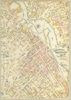
Partial cadastral map. and SMLMAPL 766 B76 1904: Imperfect: chipped at edges, with no loss of text. Library of Congress copyright stamp.
Subject (Geographic):
Bridgeport (Conn.)--Maps
Subject (Name):
Library of Congress Stamp
Subject (Topic):
Fire risk assessment--Connecticut--Bridgeport--Maps and Real property--Connecticut--Bridgeport--Maps
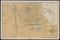
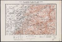
"Entered according to Act of Parliament of Canada in the year 1898 by the Province Publishing Company, Ltd. Lty. at the Department of Agriculture." and Shows roads, trails, settlements, claims.
Publisher:
Provincial Publishing Co.,
Subject (Geographic):
Cariboo (B.C. : Regional district)--Maps
Subject (Name):
British Columbia. Dept. of Lands and Works
Subject (Topic):
Mines and mineral resources--British Columbia--Cariboo District--Maps
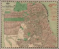
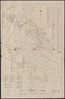
Guide to Helena, Montana and Guide to the capital city of Montana, Helena.
Description:
Guidebook gives description, Guidebook title page: A guide to the capital city of Montana, Helena., On verso: Index to subdivisions and streets., and Shows streets, railroad and streetcar lines, and additions to the city. Includes photograph and advertisements.
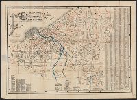
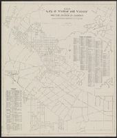
Map of Whittier California and vicinity and Road and resort map, south Pacific Coast Region.
Description:
Copyright date on map: 1931., Copyright: J.M. Kemmerer., Includes indexes and distance list., and Includes text, distance list, and "Road and resort map, south Pacific Coast Region" (copyright, Touring League of America).
Publisher:
Whittier Chamber of Commerce,
Subject (Geographic):
Whittier (Calif.)--Maps
Subject (Name):
Kemmerer, J. M and Whittier Area Chamber of Commerce
Subject (Topic):
Roads--California--Maps and Streets--California--Whittier--Maps