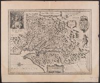
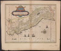
Hendrik Hondius' derivative of John Smith's map of Virginia, 1612., Oriented with north to the right., Relief shown pictorially., Sheet measures 47.6 x 57.7 cm. Franklin Collection no. 131 1633., and Verso in French, with running and caption title "Description de la Virginie," signatures 8O2, and catchword "peu".
Publisher:
Ex officina Henrici Hondii,
Subject (Geographic):
Chesapeake Bay (Md. and Va.)--Maps--Early works to 1800, Maryland--Maps--Early works to 1800, and Virginia--Maps--Early works to 1800
Subject (Name):
Jansson, Jan, 1588-1664. Atlas novus. French and Smith, John, 1580-1631
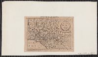
Based on John Smith's map of Virginia., From Gerardus Mercator's Altas minor (French ed.) ... A Amsterdam : Chez Iean Iansson, 1630., Map in Latin, with pagination "631." Text on verso in French., Mounted on paper. Sheet measures 14.5 x 20.3 cm. Cross Collection no. 209., Oriented with north towards the right., and Relief shown pictorially.
Publisher:
Jan Jansson,
Subject (Geographic):
Virginia--Maps--Early works to 1800
Subject (Name):
Keere, Pieter van den, 1571-ca. 1646, Mercator, Gerhard, 1512-1594. Atlas minor. French, and Smith, John, 1580-1631
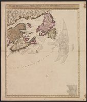
Carte nouvelle contenant la partie d'Amerique la plus septentrionale : ou sont exactement dêcrites les provinces suivantes comme le Canada ou Nouvelle France, la Nouvelle Ecosse, la Nouvelle Angleterre, les Nouveaux Paı̈s Bas, la Pensylvanie, la Virginie
Description:
"Cum privilegio ordinum generalium foederati Belgii.", Appears in some eds. of the author's Atlas minor sive geographia compendiosa., Library copy incomplete, Atlantic Canada sheet only; damaged in upper left., and Relief shown pictorially. Depths shown by sound
Publisher:
Nicolao Visscher,
Subject (Geographic):
Atlantic Provinces--Maps--Early works to 1800 and North America--Maps--Early works to 1800
Subject (Name):
Anse, Luggert van, fl. 1690-1716, engraver and Visscher, Nicolaes, 1649-1702. Atlas minor sive geographia compendiosa
Blaeu, Willem Janszoon, 1571-1638 Blaeu, Willem Janszoon, 1571-1638. Theatrum orbis terrarum. French Ende, Josua van den, ca. 1584-ca. 1634 Hooft, Cornelis Pieterszoon, 1547-1626
Published / Created:
[between 1635 and 1650]
Call Number:
11 1635
Container / Volume:
BRBL_00003
Image Count:
2
Resource Type:
Maps, Atlases & Globes
Description:
Appears in the author's Theatrum orbis terrarum. 1635., Dedicated to "Cornelio Petri fan Hooft.", Described in: The mapping of the world / Rodney W. Shirley. London : Holland Press, 1983. No. 255, state 4., Includes insets of the po, and Relief shown pictorially.
Anville, Jean Baptiste Bourguignon d', 1697-1782, cartographer
Published / Created:
[1767]
Call Number:
50 1767
Container / Volume:
BRBL_00271
Image Count:
1
Resource Type:
Maps, Atlases & Globes
Description:
Cartographer and publication date from dealer's notes., Country labels in French., Inset: Supplement pour l'Asie et l'Afrique., Relief shown pictorially., Shows most of the Middle East, and part of Egypt., Stamp on verso: 27., and Watermark.
Publisher:
[publisher not identified],
Subject (Geographic):
Middle East--Maps--Early works to 1800, Palestine--History--To 70 A.D.--Maps--Early works to 1800, and Palestine--Maps--Early works to 1800
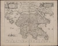
Coordinates not present on map and are approximated., Includes four bar scales., Relief shown pictorially., Verso blank., and Watermark. Manuscript number in upper left corner: 31. Manuscript annotation at top: Thebo.
Publisher:
[Jan Jansson],
Subject (Geographic):
Peloponnesus (Greece : Peninsula)--Maps--Early works to 1800.
Bar scales in "Milliaria Gallica communia," "Leucae Hispanicae," and "Milliaria Germanica communia.", Cross Collection no. 355., From Blaeu's Le theatre du monde ... Amsterdami : Apud Guiljelmum et Iohannem Blaeu, 1635., In French on verso, with caption title "Chili" and signature 7N., Oriented with north to the left., and Relief shown pictorially.
Publisher:
Guiljelmus Blaeuw excudit,
Subject (Geographic):
Peru--Maps--Early works to 1800
Subject (Name):
Blaeu, Joan, 1596-1673. Theatrum orbis terrarum. French and Blaeu, Willem Janszoon, 1571-1638. Theatrum orbis terrarum. French
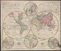
Mappe-monde qui représente les deux hemisphères savoir celui de l'orient et celui de l'occident, tirée des quatre cartes générales de feu M. le profess. Hasius, Planiglobii terrestris mappa vniversalis, and Schul-Atlas von zwantzig General- und Special-Lan
Description:
Appears in Homann heirs' Schul-atlas von zwantzig general-und special-land karten ... Cf. Phillips, no. 293., Imperfect: torn along fold, with no loss of text. Shee, Map colored to show distribution of religions., and Title in Latin and French; legend in German.
Publisher:
Homann Erben],
Subject (Name):
Hase, Johann Matthias, 1684-1742 and Homann Erben (Firm)
Subject (Topic):
Religion--Maps--Early works to 1800 and World maps--Early works to 1800
Lowitz, G. M. (George Moritz), 1722-1774, cartographer.
Call Number:
11 1746A
Image Count:
1
Resource Type:
Maps, Atlases & Globes
Alternative Title:
Mappe-monde qui représente les deux hemisphères savoir celui de l'orient et celui de l'occident, tirée des quatre cartes générales de feu M. le profess. Hasius and Planiglobii terrestris mappa vniversalis
Description:
Includes color illustrations, 4 ancillary maps showing poles, and 2 diagrams., Map colored to show distribution of religions., Mounted on linen. Sheet measures 49 x 61 cm. Cross collection no. 39., Relief shown pictorially., Title in Latin and French., and Variant with privilege statement "Cum Priv. S. Caes .Maj." in Latin cartouche and "Avec Priv. de S. Maj. Imper." in French cartouche, Fig. I, Fig. III, and Fig. IV. centered in the French cartouche, and with a detailed outline of Alaska and the Aleutian Archipelago.
Subject (Name):
Hase, Johann Matthias, 1684-1742. and Homann Erben (Firm), publisher.
Subject (Topic):
Religion--Maps--Early works to 1800. and World maps--Early works to 1800.