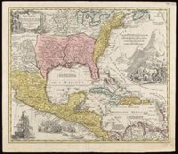
Appears in Homann's Atlas geographicus major ... Normibergae : Curantibus Homannianis heredibus, 1759., Copy 2: Watermark. Manuscript number on verso, "28." Sheet measures 53 x 61 cm. Cross Collection no. 237., Includes notes, ill. of ships in battle, and of Europeans and Native Americans, and four bar scales., Relief shown pictorially., Some references suggest earlier possible imprint date., and This edition is at least the second state, as Ludoviciana has replaced Florida as the name of the Louisiana territory.
Publisher:
[Homann Erben?,
Subject (Geographic):
New Spain--Maps--Early works to 1800. and North America--Maps--Early works to 1800.
Subject (Name):
Homann Erben (Firm) and Homann, Johann Baptist, 1663-1724. Atlas geographicus major.
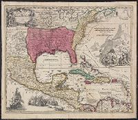
Appears in Homann's Atlas geographicus major ... Normibergae : Curantibus Homannianis heredibus, 1759., Copy 1: Ms. no. on verso: 107. Stamp on verso: Yale, Horace Brown, 1900S. Neat line measures 47.6 x 57.5 on sheet 52 x 62 cm., and Includes notes, ill. of sh
Publisher:
[Homann Erben?,
Subject (Geographic):
New Spain--Maps--Early works to 1800 and North America--Maps--Early works to 1800
Subject (Name):
Homann Erben (Firm) and Homann, Johann Baptist, 1663-1724. Atlas geographicus major
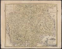
Carte general d ́Espagne et de Portugal diviseé en ses provinces actuelles par D.T. Lopez, nouvellement dressée par F.L.G. à Nuremberg chez les Heret. de Homann l ́an 1782
Description:
Bar scales given in "leguas de una hora de Camino," "leguas legales Castellanas," "leguas legales de Portugal," "leguas comunes de Francia," and "leguas geographicas ò de Alemania."
Publisher:
Edentibus Homannianis Haeredibus,
Subject (Geographic):
Portugal--Maps--Early works to 1800 and Spain--Maps--Early works to 1800
Subject (Name):
Güssefeld, F. L. (Franz Ludwig), 1744-1807 and Homann Erben (Firm)
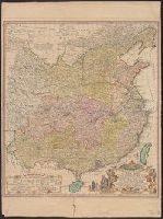
Carte generale de la Tartarie chinoise et des royaumes de Corée et de Iapan
Description:
French alternate title only., Imperfect: western sheet (with cartouche) wanting. Sheet measures 54 x 54 cm, with watermark., Includes text and ill., and Relief shown pictorially.
Publisher:
Curis Homannianorum Heredum,
Subject (Geographic):
Chine--Divisions politiques et administratives--Cartes--Ouvrages avant 1800. and Manchuria (China)--Maps--Early works to 1800.
Subject (Name):
Anville, Jean Baptiste Bourguignon d', 1697-1782., Du Halde, J.-B. (Jean-Baptiste), 1674-1743., Gerbillon, Jean-François, 1654-1707., Homann Erben (Firm), and Mayer, Tobias, 1723-1762.
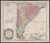
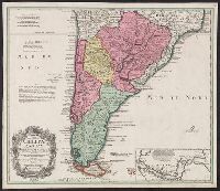
In Latin and French., Includes inset of the Straights of Magellin., Mounted on linen. Sheet measures 53.1 x 62.4 cm., Prime meridian: Ferro., and Relief shown pictorially.
Publisher:
Editoribus Homannianis Heredibus, Norib,
Subject (Geographic):
South America--Maps--Early works to 1800
Subject (Name):
Homann Erben (Firm) and Techo, Nicolás del, 1611-1685
In Latin and French., Includes inset of the Straights of Magellin., Prime meridian: Ferro., Relief shown pictorially., and Sheet measures 50.6 x 58.7 cm. Blue tab pasted on left verso, with stamp "Printed in Germany."
Publisher:
Editoribus Homannianis Heredibus, Norib,
Subject (Geographic):
South America--Maps--Early works to 1800
Subject (Name):
Homann Erben (Firm) and Techo, Nicolás del, 1611-1685
Bar scales given in "milliaria duo Germanica" and "milliaria Italica.", Hand colored. Stamp: Karpinski-von Wieser Map Collection. Manuscript notes in unidentified hand., Prime meridian: Ferro., and Relief shown pictorially.
Publisher:
Edentibus Homannianis Hered., C.P.S.C.M.,
Subject (Geographic):
Trentino-Alto Adige (Italy)--Maps--Early works to 1800 and Tyrol (Austria)--Maps--Early works to 1800