Campbell, E. Simms (Elmer Simms), 1906-1971, creator
Call Number:
BrSides Double Folio 2016 34
Image Count:
1
Resource Type:
cartographic image
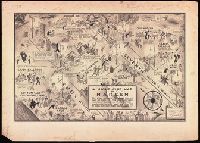
Description:
BEIN BrSides Double Folio 2016 34: Mounted on board. Stamp in upper left corner, "Manhattan." Scant manuscript annotations at bottom. and North oriented towards the lower right.
Subject (Geographic):
Harlem (New York, N.Y.), New York (State), and New York
Subject (Name):
Cotton Club., Connie’s Inn (New York, N.Y.), Small’s Paradise (Nightclub : Harlem, New York, N.Y.), Lafayette Theater (New York, N.Y. : 132nd Street), Club Hot-Cha (New York, N.Y.), Yeah Man (Nightclub : New York, N.Y.), Tillie's (Nightclub : New York, N.Y.), Radium Club (New York, N.Y.), Calloway, Cab, 1907-1994, Bentley, Gladys, Robinson, Bill, 1878-1949, and Tucker, Snakehips
Subject (Topic):
Social life and customs, African American neighborhoods, Nightclubs, and Harlem Renaissance
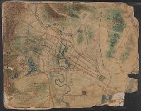
Bookplate of Peter E. Keyser. Bookplate signed by P.D. Keyser ... Philadelphia, Pa., Manuscript label on cover: A-24., and Includes ninety-three blanks pages at end.
Subject (Geographic):
Germantown (Philadelphia, Pa.), Pennsylvania, and Philadelphia.
Imperfect: mutilated., Title devised by cataloger., North oriented towards the right., Color: green with blue and red detail., and Coordinates not present on map and are approximated.
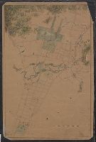
Map of Horse Railroad, Westville, and part of New Haven
Description:
Imperfect: mutilated., Map attributed to Donald Grant Mitchell., Backed with paper., Relief shown by hachures., "Scale of five inches to mile.", Color: green with blue and red detail., and Coordinates not present on map and are approximated.
Imperfect: mutilated. Mounted on linen. Manuscript note on verso (partially trimmed): Map of old P[?]; D.G. Mitchell., Date of production precedes statement of responsibility., Oriented with north towards right., Relief shown by hachures., "Scale: 140 ft. to inch.", Coordinates not present on map and are approximated., Includes names of ownership., and Includes inset map of surrounding area in lower right corner.
Title supplied by cataloger., Nineteenth century forgery of a portlan chart., Manuscript note in accompanying case: A manuscript portolan on vellum probably executed by a Spanish chartmaker circa 1550, the coasts outlined in green with place names in gothic letters of red and black, decorated with devices of the sun and moon in umber heightened with gold, 14 x 9 inches. This chart is a rare example from its unusally small size. RH. 7487., and Pen and ink wash color on parchment, in Italian, in unidentified hand.
Twentieth century forgery of a portlan chart with seaport names given for all coastlines; based on chart from the circle of Vesconte Maggiolo., Title devised by cataloger., Pen-and-ink in gold, brown, red, blue, and green., Contains eight compass roses., Decoration: armorial shields, city views with gilded banners, tents, and Madonna with child., Pasted on wood backing with modern brocade edging., and Coordinates not present on map and are approximated.
Subject (Geographic):
Mediterranean Sea, North Atlantic Ocean, Black Sea, Africa, West, Mediterranean Sea., North Atlantic Ocean., Black Sea., and Africa, West.
Title devised by cataloger., "Vinc[enti]us demetrei Volcius Rachuseus. Fecit interra Liiburni die 24 Maius 1601.", With blue cloth tie at left edge., Color: red, blue, and some gold., With four compass roses., and Coordinates not present on map and are approximated.