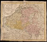
Belgium Catholicum seu decem provinciae Germaniae inferioris and Carte des Pais Bas catholiques où des X provinces de l'Allegmagne inférieure, etc. dessinée au juste selon les exactes observations astronomiques et opérations géometriques des Messur. Cass
Description:
"Avec privil. Imperial" above neat line., Includes 8 bar scales., Includes coats-of-arms of ten provinces., Relief shown pictorially., and Watermark. Manuscript number in upper right corner: 262[?]. From the Karpinski-von Wieser Map Collection.
Publisher:
Edentibus Homannianis heredib.,
Subject (Geographic):
Belgium--Maps--Early works to 1800. and Luxembourg--Maps--Early works to 1800.
Subject (Name):
Cassini, César-François, 1714-1784, Homann Erben (Firm), and Snellius, Willebrord, 1580-1626
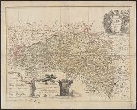
"Cum priv. Sac. Caes. Majestatis.", Backed with linen. Sheet measures 50.8 x 63.1 cm., Bar scales given in "geographische Meilen," "Roth Reussi[sche] und Pocuti[sche] Meilen," and "Hungarische Meilen.", Prime meridian: Paris., Relief shown pictorially., and Title
Publisher:
Impensis Homannianorum Haeredum,
Subject (Geographic):
Bohemia (Czech Republic)--Maps--Early works to 1800, Galicia (Poland and Ukraine)--Maps--Early works to 1800, and Ukraine--Maps--Early works to 1800
Carte general d ́Espagne et de Portugal diviseé en ses provinces actuelles par D.T. Lopez, nouvellement dressée par F.L.G. à Nuremberg chez les Heret. de Homann l ́an 1782
Description:
Bar scales given in "leguas de una hora de Camino," "leguas legales Castellanas," "leguas legales de Portugal," "leguas comunes de Francia," and "leguas geographicas ò de Alemania."
Publisher:
Edentibus Homannianis Haeredibus,
Subject (Geographic):
Portugal--Maps--Early works to 1800 and Spain--Maps--Early works to 1800
Subject (Name):
Güssefeld, F. L. (Franz Ludwig), 1744-1807 and Homann Erben (Firm)
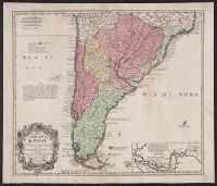
In Latin and French., Includes inset of the Straights of Magellin., Mounted on linen. Sheet measures 53.1 x 62.4 cm., Prime meridian: Ferro., and Relief shown pictorially.
Publisher:
Editoribus Homannianis Heredibus, Norib,
Subject (Geographic):
South America--Maps--Early works to 1800
Subject (Name):
Homann Erben (Firm) and Techo, Nicolás del, 1611-1685
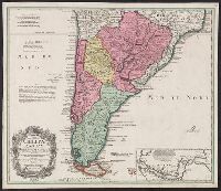
In Latin and French., Includes inset of the Straights of Magellin., Prime meridian: Ferro., Relief shown pictorially., and Sheet measures 50.6 x 58.7 cm. Blue tab pasted on left verso, with stamp "Printed in Germany."
Publisher:
Editoribus Homannianis Heredibus, Norib,
Subject (Geographic):
South America--Maps--Early works to 1800
Subject (Name):
Homann Erben (Firm) and Techo, Nicolás del, 1611-1685