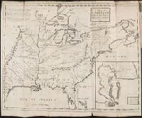
Subject: Map of Hudson River from New York City to Lake George, with plans of Fort Edward and Fort William Henry. Also includes views of the first and second engagements during the Battle of Lake George. In the "First engagement" soldiers are seen shootin
Description:
771hc H864 1756: Stamp "Yale Horace Brown 1900S." Accompanied by reproduction of map [with stamp "Yale Horace Brown 1900S"]. and Coordinates not present on map of Hudson River and are approximated.
Publisher:
Published according to act of Parliament,
Subject (Geographic):
Hudson River (N.Y. and N.J.)--Maps, New York (State)--Lake George, United States--History--French and Indian War, 1754-1763--Campaigns--Pictorial works, and United States--Hudson River
Subject (Name):
Brown, Horace--Stamp, French and Indian War (United States : 1754-1763), Jefferys, Thomas, -1771, engraver, and Lake George, Battle of (New York : 1755)
Subject (Topic):
Lake George, Battle of, N.Y., 1755--Pictorial works
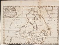
New England: the most remarqueable parts thus named by the high and mighty Prince Charles, nowe King of great Britaine [map] and Path-way to experience to erect a plantation.
Description:
Imperfect: damp-stained; added port. of Charles I., Map with portrait of Capt. Smith in corner: New England ... / observed and described by Captayn John Smith. 1614. Pendleton's Lithography, Boston. Drawn by J. Eddy. London, printed by Geor: Low., Signatures: A-F⁴., and Teaching resource: Professor John Mack Faragher, History 141: The American West.
Publisher:
Printed by I. Haviland, and are to be sold by R. Milbovrne,
Subject (Geographic):
Massachusetts--History--Colonial period, ca. 1600-1775, Massachusetts--Maps--Early works to 1800, New England--Description and travel, New England--History--Colonial period, ca. 1600-1775, and New England--Maps--Early works to 1800