
You Searched For
« Previous
| 1 - 10 of 16 |
Next »
Search Results

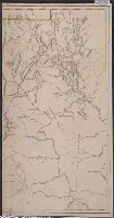
- Creator:
- Scull, William, active 1765, cartographer.
- Published / Created:
- 10 June 1775.
- Call Number:
- 774 1775
- Container / Volume:
- BRBL_00497
- Image Count:
- 2
- Resource Type:
- Maps, Atlases & Globes
- Description:
- Imprint in three places along lower left, center, and right margin., Prime meridian: London. "Longitude west from London.", Relief shown by shading and hachures., and Revolutionary War era map of Pennsylvania, compiled by Sayer & Bennett, primarily from William
- Publisher:
- Printed for Robt. Sayer & J. Bennett, map & printseller No. 53 in Fleet Street. Published as the Act directs,
- Subject (Geographic):
- Pennsylvania--Administrative and political divisions--Maps--Early works to 1800. and Pennsylvania--Maps--Early works to 1800.
- Subject (Name):
- Penn, Richard, 1706-1771, dedicatee., Penn, Thomas, 1702-1775, dedicatee., and Robert Sayer and John Bennett (Firm), publisher, printseller.
- Found in:
- Beinecke Rare Book and Manuscript Library > A map of Pennsylvania exhibiting not only the improved parts of that Province, but also its extensive frontiers: Laid down from actual surveys, and chiefly from the late map of W. Scull published in 1770; and humbly inscribed to the Honorable Thomas Penn
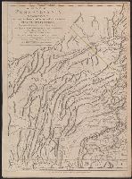
- Creator:
- Scull, William, active 1765, cartographer.
- Published / Created:
- 10 June 1775.
- Call Number:
- 774 1775
- Container / Volume:
- BRBL_00730
- Image Count:
- 3
- Resource Type:
- Maps, Atlases & Globes
- Description:
- Imprint in three places along lower left, center, and right margin., Prime meridian: London. "Longitude west from London.", Relief shown by shading and hachures., Revolutionary War era map of Pennsylvania, compiled by Sayer & Bennett, primarily from William Schull's map. The detailed map extending from Fort Pitt (formerly Fort Duquesne) in the west to the New Jersey border along the Delaware river to the east., Scale of "English Miles 69 1/2 to a Degree"., Separately published and in editions of "The North American Atlas" published by Faden; and Thomas Jefferys' The American atlas. 1775;, and Shows counties, townships, towns and cities, Indian villages, stores, churches, taverns, and names of residents in the countryside; rivers and streams, waterfalls, ferries, swamps, springs, and landmarks; mills, mines, furnaces, and forges; and forts and French and Indian War battle sites. - Cf. Seller & Van Ee, Maps and charts of North America and West Indies, 1750-1789, entry 1296.
- Publisher:
- Printed for Robt. Sayer & J. Bennett, map & printseller No. 53 in Fleet Street. Published as the Act directs,
- Subject (Geographic):
- Pennsylvania--Administrative and political divisions--Maps--Early works to 1800. and Pennsylvania--Maps--Early works to 1800.
- Subject (Name):
- Penn, Richard, 1706-1771, dedicatee., Penn, Thomas, 1702-1775, dedicatee., and Robert Sayer and John Bennett (Firm), publisher, printseller.
- Subject (Topic):
- Administrative and political divisions
- Found in:
- Beinecke Rare Book and Manuscript Library > A map of Pennsylvania exhibiting not only the improved parts of that Province, but also its extensive frontiers: Laid down from actual surveys, and chiefly from the late map of W. Scull published in 1770; and humbly inscribed to the Honorable Thomas Penn
4.

- Creator:
- Jefferys, Thomas, -1771, printmaker.
- Published / Created:
- 1755
- Call Number:
- 783 1755F
- Container / Volume:
- BRBL_00507
- Image Count:
- 1
- Resource Type:
- Maps, Atlases & Globes
- Description:
- A textual note at upper left reads "The Course of the Ohio or Alliganey River and its Branches are laid down from Surveys and Draughts made on the Spot by M.r Gist and others in the Years 1751, 2, 3 & 4". and Cartouche designed by Francis Hayman and engraved
- Publisher:
- Thomas Jefferys,
- Subject (Geographic):
- Maryland--Maps--Early works to 1800., Middle Atlantic States--Maps--Early works to 1800., and Virginia--Maps--Early works to 1800.
- Subject (Name):
- Byrd, William, 1674-1744., Churton, William, 1710-1767, surveyor., Dalrymple, John, -1766, surveyor., Dandridge, William, -1743., Fitzwilliam, Richard, -1744., and Fry, Joshua, approximately 1700-1754, ca
- Found in:
- Beinecke Rare Book and Manuscript Library > A map of the most inhabited part of Virginia containing the whole province of Maryland with part of Pensilvania, New Jersey and North Carolina / drawn by Joshua Fry & Peter Jefferson in 1751.
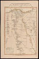
- Creator:
- Anville, Jean Baptiste Bourguignon d', 1697-1782
- Published / Created:
- 1st April 1812.
- Call Number:
- 61 1812B
- Image Count:
- 2
- Resource Type:
- Maps, Atlases & Globes
- Description:
- "9"--Manuscript note in upper right corner of sheet. Accompanied by: Title page: A complete body of ancient geography by Mons. D'Anville ... London : James Whittle and Richard Holmes Laurie, 1818 (1 sheet)., Includes index., Includes six bar scales., Prime meridian: Ferro., Relief shown by hachures., and Watermark.
- Publisher:
- Laurie & Whittle,
- Subject (Geographic):
- Egypt--Administrative and political divisions--Maps. and Egypt--Maps.
- Subject (Name):
- Laurie & Whittle
- Subject (Topic):
- Historical geography.
- Found in:
- Beinecke Rare Book and Manuscript Library > Aegyptus Antiqua Mandato Serenissimi Delphini publici juris facta / Auctor d'Anville Regiae Humaniorum Litterarum Academiae et scientiarum Petropolitanae socius, et Aurelianorum Celsiss. Duci a Secretis. MDCCLXV.
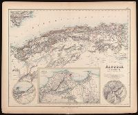
- Creator:
- Johnson, J. Hugh (John Hugh)
- Published / Created:
- [1872?]
- Call Number:
- BrSides Folio 2019 97
- Image Count:
- 1
- Resource Type:
- Maps, Atlases & Globes
- Alternative Title:
- Algérie, Algiers and environs on an enlarged scale., Constantine and environs., and Oran and environs.
- Description:
- Appears in: Royal illustrated atlas of modern geography. London ; Edinburgh : A. Fullarton and Co., [1872?]. (pl. XLVI)., Inset maps: 1. Algiers and environs on an enlarged scale. Scale [ca. 1:1,050,000] -- 2. Constantine and environs -- 3. Oran and environs., Relief shown by hachures., and Stamp in upper right corner: 46.
- Publisher:
- A. Fullarton and Co.,
- Subject (Geographic):
- Algeria--Maps.
- Subject (Name):
- A. Fullarton & Co., A. Fullarton & Co. Royal illustrated atlas of modern geography., and Edward Stanford Ltd.
- Found in:
- Beinecke Rare Book and Manuscript Library > Algeria [cartographic material] = l'Algérie / drawn by J. Hugh Johnson ; engraved at Stanford's Geographical Establishment.
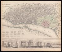
- Creator:
- Society for the Diffusion of Useful Knowledge (Great Britain)
- Published / Created:
- Novr. 1842.
- Call Number:
- BrSides Folio 2019 94
- Image Count:
- 1
- Resource Type:
- Maps, Atlases & Globes
- Description:
- Coordinates not present on map and are approximated., Includes "References to the public buildings, churches & chapels" and illustrations of Writers Buildings, Government House and Esplanade Row., and Oriented with north to lower left.
- Publisher:
- Published by Chapman & Hall, 186 Strand,
- Subject (Geographic):
- Kolkata (India)--Maps.
- Subject (Name):
- Chapman and Hall
- Found in:
- Beinecke Rare Book and Manuscript Library > Calcutta / published under the superintendence of the Society for the Diffusion of Knowledge.
8.

- Creator:
- Cruchley, G. F.
- Published / Created:
- February 1st, 1842.
- Call Number:
- BrSides Folio 2019 90
- Image Count:
- 1
- Resource Type:
- Maps, Atlases & Globes
- Alternative Title:
- Cruchley's improved atlas for schools & families and Cruchley's improved atlas for schools and families
- Description:
- Relief shown by hachures.
- Publisher:
- Engraved & published by G.F. Cruchley, mapseller, 81 Fleet Street,
- Subject (Geographic):
- China--Maps.
- Found in:
- Beinecke Rare Book and Manuscript Library > China.
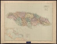
- Creator:
- Edward Stanford Ltd.
- Published / Created:
- [192-?]
- Call Number:
- 8555 1920
- Container / Volume:
- BRBL_00642
- Image Count:
- 1
- Resource Type:
- Maps, Atlases & Globes
- Alternative Title:
- London atlas series
- Description:
- "2827.", "BCM/Stanfordmaps.", "Printed in Great Britain.", Includes ancillary map, "The West Indies and Central America.", Label: International Map Company ... New York, N.Y. Backed with linen., and Relief shown by shading and spot heights.
- Publisher:
- Edward Stanford Ltd., 12, 13, & 14 Long Acre W.C.,
- Subject (Geographic):
- Jamaica--Maps.
- Subject (Name):
- Edward Stanford Ltd. and International Map Company Bookplate.
- Found in:
- Beinecke Rare Book and Manuscript Library > Jamaica [cartographic material] / Stanford's Geographical Establishment.

- Creator:
- Stokes, John Lort, 1811-1885, cartographer.
- Published / Created:
- April 10, 1845.
- Call Number:
- BrSides Double Folio 2019 108
- Image Count:
- 1
- Resource Type:
- Maps, Atlases & Globes
- Alternative Title:
- Australia Gulf of Carpentaria :
- Description:
- At head of title: Australia Gulf of Carpentaria., Coordinates not present on map and are approximated., In lower right corner: 1708., and Soundings in fathoms.
- Publisher:
- Hydrographic Office of the Admiralty,
- Subject (Geographic):
- Queensland.
- Subject (Name):
- Bate, R. B. (Robert Brettell), bookseller., Great Britain. Hydrographic Office, publisher., and J. & C. Walker (Firm), engraver.
- Subject (Topic):
- Albert River (Qld.)--Maps., Albert River (Qld.)--Navigation--Maps., and Nautical charts--Australia--Queensland.
- Found in:
- Beinecke Rare Book and Manuscript Library > The Albert River : 1841 / surveyed by J.L. Stokes, R.N. ; J. & C. Walker, sculpt.