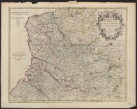
Appears in Senex's A new general atlas ... London: Printed for Daniel Browne ... [etc.], 1721., Decorative title carouche., Dedicated to Richard Temple., London meridian., Relief shown pictorially and by hachures., and Shows boundaries, rivers, roads, canals, fore
Publisher:
Engrav'd by Iohn Senex and sold by him ... London,
Subject (Geographic):
Artois (France)--Early works to 1800--Maps
Subject (Name):
Cobham, Richard Temple, Viscount, 1669?-1749, dedicatee, Senex, John, d. 1740, dedicator, and Senex, John, d. 1740. New general atlas
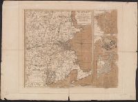
From Thomas Jeffery's American atlas. 1778., Imperfect: southern portion of text torn along fold and separated. Sheets pasted together to form one map. No. "17" stamped on verso, upper right corner., Insets: A chart of the mouth of Hudson's River, from Sandy Hook to New York.--A plan of the city of New York.--Plan of Amboy, with its environs, from an actual survey., Prime meridian: London., Relief shown pictorially., Shows administrative divisions., and Watermarks.
Publisher:
Printed for Robt. Sayer & John Bennett ...,
Subject (Geographic):
New Jersey--Administrative and political divisions--Maps--Early works to 1800., New Jersey--Maps--Early works to 1800., New York (N.Y.)--Maps--Early works to 1800, New York (State)--Administrative and political divisions--Maps--Early works to 1800., Northeastern States, Northeastern States--Maps--Early works to 1800., Perth Amboy (N.J.)--Maps--Early works to 1800., and Québec (Province)--Maps--Early works to 1800
Subject (Name):
Holland, Samuel, 1728-1801 and Robert Sayer and John Bennett (Firm)
Mer, Printed on sheet with 3 maps total: [1.] The seat of war in New England -- [2.] Plan of Boston Harbour -- [3.] Plan of the town of Boston with the attack on Bunkers-Hill in the peninsula of Charlestown, the 17th of June 1775., and Relief shown by hachures.
Publisher:
Printed for R. Sayer & J. Bennett, No. 53 Fleet Street, as the act directs,
Subject (Geographic):
Boston (Mass.)--History--Siege, 1775-1776--Maps--Early works to 1800, New England--History--Revolution, 1775-1783--Maps--Early works to 1800, New England--Maps--Early works to 1800, and United States--History--Revolution, 1775
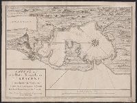
"This map is copied from an original drawn by Monsr. D'Anville ... & published at Paris in 1751. But since the Peace of 1762, that map has been supressed [sic] ... ", Includes descriptive notes,, Prime meridians: Ferro and London., and Relief shown pictorially.
Publisher:
Printed for Robert Sayer in Fleet Street & Thomas Jefferys in the Strand,
Subject (Geographic):
Africa, West--Maps--Early works to 1800, Coasts--Africa, West--Maps--Early works to 1800, and Gambia--Colonization--Maps--Early works to 1800
Subject (Name):
Anville, Jean Baptiste Bourguignon d', 1697-1782 and Sayer, Robert, 1725-1794
"This map is copied from an original drawn by Monsr. D'Anv, Also appeared in Kitchin's General atlas describing the whole universe. London : Printed for Robert Sayer, [1780]., Prime meridians: Ferro and London., and Relief shown pictorially; depths by soundings.
Publisher:
Printed for Robert Sayer,
Subject (Geographic):
Africa, West--Maps--Early works to 1800
Subject (Name):
Abbot, Charles,--Baron Colchester,--1757-1829--Bookplate, Anville, Jean Baptiste Bourguignon d', 1697-1782, Kitchin, Thomas, d. 1784. General atlas describing the whole universe, and Robert Laurie and James Whittle