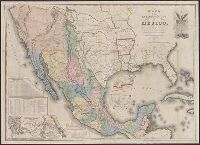
Carta de los caminos &c. desde Vera Cruz y Alvarado a Méjico.
Description:
Includes distance table, list of states, "Profile of the route between Mexico and Vera Cruz," and "Profile of the route btween [sic] Mexico and Acapulco.", Insets: Carta de los caminos &c. desde Vera Cruz y Alvarado a Méjico -- Map showing the battle grounds of the 8th and the 9th, May 1846 -- Chart of the Bay of Vera Cruz., Prime meridian: Washington., and Relief shown by hachures and spot heights.
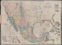
Carta de los caminos &c. desde Vera Cruz y Alvarado a Méjico. and Map of the Republic of Mexico
Description:
Includes distance table, list of states, "Profile of the route between Mexico and Vera Cruz," and "Profile of the route btween [sic] Mexico and Acapulco.", Inscription on inside of covers, "W.C. Wescott, U.S. Army.", Insets: Carta de los caminos &c. desde Vera Cruz y Alvarado a Méjico -- Map showing the battle grounds of the 8th and the 9th, May 1846 -- Plan of Monterey and its environs -- Chart of the Bay of Vera Cruz -- Tampico and its environs., Prime meridian: Washington., Relief shown by hachures and spot heights., and Statistical data inside cover.