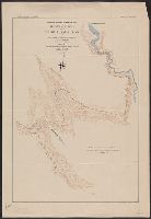
Boletín del Cuerpo de Ingenieros de Minas del Perú. and Proyecto para irrigar el Valle de Ica plana perfil y corte represa de la laguna de Choclococha
Description:
Boletín no. 28, lámina no. 3. and Stamp and ms. on verso: "Yale University Map Collection gift of Hiram Bingham". Stamped on verso: "The South American Explaoration Fund Yale University", "Bought of F. Perex de Velasco October 1912."
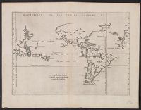
From Herrera y Tordesillas's Descripción de las Indias Occidentales ... Amstelodami : Apud M. Colinium, 1622., Map of the World from China, west to Spain showing the 'Merida, Relief shown pictorially., and Sheet measures 28.5 x 36.9 cm. Cross Collection no. 112.
Publisher:
Michiel Colijn,
Subject (Geographic):
World maps--Early works to 1800
Subject (Name):
Colijn, Michiel, Herrera y Tordesillas, Antonio de, d. 1625. Descripción de las Indias Occidentales. Latin, and Portugal.--Treaties, etc.--Spain--(1494 June 7)
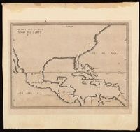
Appears in French eds. of Herrera y Tordesilla's Descripción de las Indias Occidentales published in Amsterdam., Sheet measures 28.7 x 35.2 cm. Cross Collection no. 227., and Shows coasts of the southern part of North America, Central America, northern coast of South America, and West Indies.
Publisher:
Michiel Colijn,
Subject (Geographic):
America--Maps--Early works to 1800., Central America--Maps--Early works to 1800., and West Indies--Maps--Early works to 1800.
Subject (Name):
Colijn, Michiel, publisher. and Herrera y Tordesillas, Antonio de, -1625. Descripción de las Indias Occidentales. French.
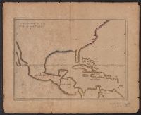
Appears in French eds. of Herrera y Tordesilla's Descripción de las Indias Occidentales published in Amsterdam., Sheet measures 28.7 x 35.2 cm. Cross Collection no. 227., and Shows coasts of the southern part of North America, Central America, northern coast of South America, and West Indies.
Publisher:
s.n. ,
Subject (Name):
Herrera y Tordesillas, Antonio de, d. 1625. Descripción de las Indias Occidentales. French
Subject (Topic):
Coasts--Central America--Maps--Early works to 1800, Coasts--North America--Maps--Early works to 1800, Coasts--South America--Maps--Early works to 1800, and Coasts--West Indies--Maps--Early works to 1800