Bar scales given in "lieues marines de France et d'Angleterre," "lieues marines d'Espagne," and "lieues communes d'Allemagne"., Prime meridian: Ferro., Relief shown pictorially; depths shown by soundings, Sheet measures 57.2 x 78.3 cm., and Watermark.
Buache, Philippe, 1700-1773 Liebaux, Henri, engraver L'Isle, Guillaume de, 1675-1726
Published / Created:
1706 [i.e. 1745]
Call Number:
352 1745
Container / Volume:
BRBL_00104
Image Count:
2
Resource Type:
Maps, Atlases & Globes
Description:
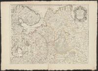
Bar scales given in "verstes, In bottom margin of sheet 2: Ph[ilippe] Buache, p[remier] g[éographe] d[u] R[oy]; d[e] l'A[cadémie] r[oyale] d[es] s[ciences]. Gendre de l'auteur. Avec privilége du 30 av[ril] 1745., and Sheets 54 x 71 cm. or smaller.
Liebaux, Henri, engraver L'Isle, Guillaume de, 1675-1726
Published / Created:
1706
Call Number:
352 1706
Container / Volume:
BRBL_00104
Image Count:
2
Resource Type:
Maps, Atlases & Globes
Description:
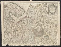
Bar scales given in "verstes ou milles de Moscovie," "lieues communes de Pologne," and "lieues communes d'Ukraine"., Dedication: À son excellence Monseig, Prime meridian: Ferro., Relief shown pictorially., Sheets 57 x 79 cm. or smaller., and Watermarks.
In title cartouche: "A Paris chez l'auteur sur le Quai de l'Horloge a l'Aigle d'Or avec priv, Lower left of title cartouche: erased text., and Verso: stamped "Yale UL", "Yale University Library Karpinski-von Wieser Map Collection"; annotation in ink manuscript.
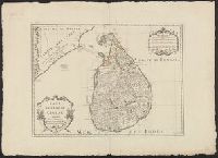
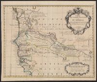
Covers portion of western Africa from Mauritania to Guinea., Includes text and ornamental cartouche., Prime meridian: Ferro., Relief shown pictorially., and Verso: stamped "Map Collection Yale Univ. Library" and numbered "46" in ink in upper right corner.
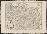
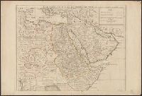
"Avec privilege pour 20 ans.", Covers Africa east of Algeria and north of the equator., Has watermark., Includes text., Relief shown pictorially., and Sheet measures 54 x 73 cm. Ms. no. on verso: 77.
Publisher:
Chez l'auteur sur le Quai de l'Horloge a l'Aigle d'Or,
"Avec privilege pour 20 ans.", Covers Africa east of Algeria and north of the equator., Has watermark., Includes text., Relief shown pictorially., and Sheet measures 54 x 73 cm. Ms. no. on verso: 77.
Publisher:
Chez l'auteur sur le Quai de l'Horloge a l'Aigle d'Or,
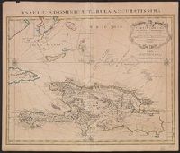
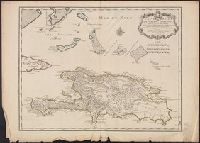
"Lieues marines Fr, Also shows southern part of Bahamas and Turks and Caicos Islands., Appears in de L'Isle's Atlas nouveau., Cross Collection no. 268., Ms. no. on verso: 10A., and Relief shown pictorially. Depths shown by shading.
Publisher:
Chez Jean Cóvens et Corneille Mortier, geographes,
Subject (Geographic):
Bahamas--Maps--Early works to 1800, Hispaniola--Maps--Early works to 1800, and Turks and Caicos Islands--Maps--Early works to 1800
Subject (Name):
Cóvens et Mortier, Frézier, Amédée François, 1682-1773, and L'Isle, Guillaume de, 1675-1726. Atlas nouveau
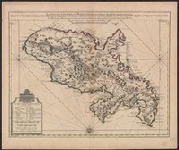
Bar scales given in "Lieues Marines et d'Espagne de 17 1/2 au Degré" and "Lieues Com. de France dont 25 font un Degré.", From Guillaume de L'Isle's Atlas nouveau, contenant toutes les parties du monde. Amsterdam : Chez Jean Cóvens & Corneille Mortier, [1742]., and Prime meridian: Ferro.
Publisher:
Chez Jean Covens et Corneille Mortier, geographes,
Subject (Geographic):
Martinique--Maps--Early works to 1800
Subject (Name):
Buache, Philippe, 1700-1773, Cóvens et Mortier, printer, and L'Isle, Guillaume de, 1675-1726. Atlas nouveau
"Lieues marines Francoises de 20, "Marin sculpsit.", Also shows southern part of Bahamas and Turks and Caicos Islands., Cross Collection no. 269., Hand col., Ms. no. on verso: 55., and Relief shown pictorially. Depths shown by shading.
Publisher:
Chez l'Auteur sur le Quay de l'Horloge ...,
Subject (Geographic):
Bahamas--Maps--Early works to 1800, Hispaniola--Maps--Early works to 1800, and Turks and Caicos Islands--Maps--Early works to 1800