[Atlas factice of 42 maps, produced by the Homann Erben firm]
Image Count:
1
Resource Type:
Maps, Atlases & Globes
Alternative Title:
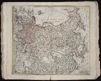
Imperii Russici et Tatariae universae tam majoris et Asiaticae, quam minoris et Europaeae tabula
Description:
"Cum privil. S.C.M. nec non R.M. Pol. et E. Sax.", Bar scale about 38 German miles to a centimeter., Decorated title cartouche depicts two hunters with rifles, a bear, and dog., Imperfect: edges frayed, torn along fold, with no loss of text. No. 33 of 42 maps bound together., In lower left margin: Notati etiam in hac mappa extant limites inter Russiam et Tatariam minorem post pacem recentissime a[nn]o 1739 initam., Includes dedicatory cartouche to Anna, Empress of Russia in upper left corner., Prime meridian: Paris., Relief shown pictorially., and Sea of Korea referred to as "Mare Orientale Minus."
Publisher:
Impensis Homannianorum Heredum
Subject (Geographic):
China--Maps--Early works to 1800., India--Maps--Early works to 1800., Japan--Maps--Early works to 1800., Korea--Maps--Early works to 1800., Russia--Maps--Early works to 1800., and Tibet (China)--Maps--Early works to 1800.
Subject (Name):
Anna,--Empress of Russia,--1693-1740., Homann Erben (Firm), and Schneider, R. A., engraver.
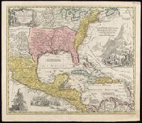
Covers the area from Lake Superior to Kaskaskia and from Delaware Bay to the Mississippi River., Relief shown pictorially., Shows a few towns, missions, forts, Indian villages and tribal territory, rivers and lakes, portages, and early place-names., and Watermark.
Publisher:
[Homann Erben?],
Subject (Geographic):
Canada--Maps--Early works to 1800., Great Lakes Region (North America)--Maps--Early works to 1800., and New France--Maps--Early works to 1800.
Appears in Homann's Atlas geographicus major ... Normibergae : Curantibus Homannianis heredibus, 1759., Copy 2: Watermark. Manuscript number on verso, "28." Sheet measures 53 x 61 cm. Cross Collection no. 237., Includes notes, ill. of ships in battle, and of Europeans and Native Americans, and four bar scales., Relief shown pictorially., Some references suggest earlier possible imprint date., and This edition is at least the second state, as Ludoviciana has replaced Florida as the name of the Louisiana territory.
Publisher:
[Homann Erben?,
Subject (Geographic):
New Spain--Maps--Early works to 1800. and North America--Maps--Early works to 1800.
Subject (Name):
Homann Erben (Firm) and Homann, Johann Baptist, 1663-1724. Atlas geographicus major.
Carte generale de la Tartarie chinoise et des royaumes de Corée et de Iapan
Description:
French alternate title only., Imperfect: western sheet (with cartouche) wanting. Sheet measures 54 x 54 cm, with watermark., Includes text and ill., and Relief shown pictorially.
Publisher:
Curis Homannianorum Heredum,
Subject (Geographic):
Chine--Divisions politiques et administratives--Cartes--Ouvrages avant 1800. and Manchuria (China)--Maps--Early works to 1800.
Subject (Name):
Anville, Jean Baptiste Bourguignon d', 1697-1782., Du Halde, J.-B. (Jean-Baptiste), 1674-1743., Gerbillon, Jean-François, 1654-1707., Homann Erben (Firm), and Mayer, Tobias, 1723-1762.