Bar scale given in "milliaria Germanica communia"., From Joan Blaeu's Théâtre du monde (1643-1650)., In French on verso with caption title "Tatarie," paginated "8," and with signature H., and Relief shown pictorially.
Publisher:
[Willem Janszoon Blaeu],
Subject (Geographic):
Asia, Central--Maps--Early works to 1800. and Siberia, Eastern (Russia)--Maps--Early works to 1800.
Subject (Name):
Blaeu, Joan, 1596-1673. Theatrum orbis terrarum. French.
Carte generale de la Tartarie chinoise et des royaumes de Corée et de Iapan
Description:
French alternate title only., Imperfect: western sheet (with cartouche) wanting. Sheet measures 54 x 54 cm, with watermark., Includes text and ill., and Relief shown pictorially.
Publisher:
Curis Homannianorum Heredum,
Subject (Geographic):
Chine--Divisions politiques et administratives--Cartes--Ouvrages avant 1800. and Manchuria (China)--Maps--Early works to 1800.
Subject (Name):
Anville, Jean Baptiste Bourguignon d', 1697-1782., Du Halde, J.-B. (Jean-Baptiste), 1674-1743., Gerbillon, Jean-François, 1654-1707., Homann Erben (Firm), and Mayer, Tobias, 1723-1762.
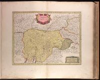
Backed with paper. Ms. no. "68" in upper right corner. Sheet measures 53.7 x 62.3 cm. No. 63 of 87 maps bound together., Bar scale given as "sette miglia Italiane.", Relief shown pictorially., and Watermark.
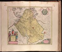
Appeared in Blaeu's Atlantis appendix, 1631., Backed with paper. Ms. no. in upper right corner: 16. Sheet measures 53.6 x 63.0 cm. No. 16 of 87 maps bound together., Relief shown pictorially., Scales given in "miglia d'Italia" and "miglia d'Allemagne"., and Watermark.
Publisher:
Apud Guiljelmus Blaeuw,
Subject (Geographic):
Trento (Italy)--Maps--Early works to 1800.
Subject (Name):
Blaeu, Willem Janszoon, 1571-1638. Atlantis appendix.
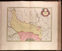
Backed with paper. Ms. no. "71" in upper right corner. Sheet measures 53.7 x 62.1 cm. No. 66 of 87 maps bound together., Bar scale given in "miglia sette Italiane.", and Relief shown pictorially.
Publisher:
Joan Blaeu,
Subject (Geographic):
Vicenza (Italy : Province)--Maps--Early works to 1800.
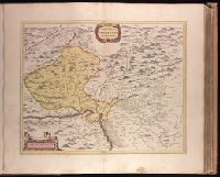
Backed with paper. Ms. no. in upper right corner: 17. Sheet measures 53.7 x 62.7 cm. No. 17 of 87 maps bound together., Includes one bar scale., Relief shown pictorially., Watermark., and With north oriented towards the bottom.
Publisher:
Joan Blaeu,
Subject (Geographic):
Basel-Stadt (Switzerland)--Maps--Early works to 1800. and Haut-Rhin (France)--Maps--Early works to 1800.
Backed with paper. Ms. no. "57" in upper-right corner. Sheet measures 53.7 x 63.6 cm. No. 52 of 87 maps bound together., Bar scales given in "milliaria Gallica" and "milliaria Germanica.", North oriented to right of map., and Relief shown pictorially.