
You Searched For
« Previous
| 1 - 10 of 366 |
Next »
Search Results

2.

- Published / Created:
- [1774]
- Call Number:
- 76 1774
- Container / Volume:
- BRBL_00729
- Image Count:
- 1
- Resource Type:
- Maps, Atlases & Globes
- Abstract:
- Subject: Map of New England and Long Island with the states divided into cities and towns. Cartouche at lower right shows Liberty leading a Native American and pilgrims to Plymouth Rock.
- Description:
- "Observations on which this map is grounded.", Copy 2: Imperfect: southern sheet wanting., Includes compilation data and insets of "A plan of the town of Boston" and "A plan of the town of Boston Harbor from an accurate sur, and Prime meridian: London and Ferro.
- Publisher:
- November 29th 1774 Published according to Act by Thos. Jefferys geographer to His Royal Highness the Prince of Wales near Charing Cross,
- Subject (Geographic):
- Boston Harbor (Mass.)--Maps and New England--Maps
- Subject (Name):
- Jefferys, Thomas, -1771, publisher
- Found in:
- Beinecke Rare Book and Manuscript Library > A Map of the most inhabited part of New England [cartographic material] : containing the provinces of Massachusets Bay and New Hampshire with the colonies of Conecticut and Rhode Island divided into counties and townships : The whole composed from actual
3.

- Published / Created:
- [1774]
- Call Number:
- 76 1774
- Container / Volume:
- BRBL_00729
- Image Count:
- 2
- Resource Type:
- Maps, Atlases & Globes
- Abstract:
- Subject: Map of New England and Long Island with the states divided into cities and towns. Cartouche at lower right shows Liberty leading a Native American and pilgrims to Plymouth Rock.
- Description:
- "Observations on which this map is grounded.", Dissected and mounted on linen., Includes compilation data and insets of "A plan of the town of Boston" and "A plan of the town of Boston Harbor from, Prime meridian: London and Ferro., and Relief shown pictorially.
- Publisher:
- November 29th 1774 Published according to Act by Thos. Jefferys geographer to His Royal Highness the Prince of Wales near Charing Cross,
- Subject (Geographic):
- Boston Harbor (Mass.)--Maps and New England--Maps
- Subject (Name):
- Jefferys, Thomas, -1771, publisher
- Found in:
- Beinecke Rare Book and Manuscript Library > A Map of the most inhabited part of New England [cartographic material] : containing the provinces of Massachusets Bay and New Hampshire with the colonies of Conecticut and Rhode Island divided into counties and townships : The whole composed from actual
4.

- Published / Created:
- [1774]
- Call Number:
- 76 1774
- Container / Volume:
- BRBL_00443
- Image Count:
- 2
- Resource Type:
- Maps, Atlases & Globes
- Abstract:
- Subject: Map of New England and Long Island with the states divided into cities and towns. Cartouche at lower right shows Liberty leading a Native American and pilgrims to Plymouth Rock.
- Description:
- "Observations on which this map is grounded.", Copy 2: Imperfect: southern sheet wanting., Includes compilation data and insets of "A plan of the town of Boston" and "A plan of the town of Boston Harbor from an accurate survey," ca. 1:150,000., and Prime meridia
- Publisher:
- November 29th 1774 Published according to Act by Thos. Jefferys geographer to His Royal Highness the Prince of Wales near Charing Cross,
- Subject (Geographic):
- Boston Harbor (Mass.)--Maps and New England--Maps
- Subject (Name):
- Jefferys, Thomas, -1771, publisher
- Found in:
- Beinecke Rare Book and Manuscript Library > A Map of the most inhabited part of New England [cartographic material] : containing the provinces of Massachusets Bay and New Hampshire with the colonies of Conecticut and Rhode Island divided into counties and townships : The whole composed from actual
5.

- Published / Created:
- [1774]
- Call Number:
- 76 1774
- Container / Volume:
- BRBL_00443
- Image Count:
- 2
- Resource Type:
- Maps, Atlases & Globes
- Abstract:
- Subject: Map of New England and Long Island with the states divided into cities and towns. Cartouche at lower right shows Liberty leading a Native American and pilgrims to Plymouth Rock.
- Description:
- "Observations on which this map is grounded.", Copy 1: Dissected and mounted on linen., Includes compilation data and insets of "A plan of the town of Boston" and "A plan of the town of Boston Harbor from an accurate survey," ca. 1:150,000., and Prime meridian:
- Publisher:
- November 29th 1774 Published according to Act by Thos. Jefferys geographer to His Royal Highness the Prince of Wales near Charing Cross,
- Subject (Geographic):
- Boston Harbor (Mass.)--Maps and New England--Maps
- Subject (Name):
- Jefferys, Thomas, -1771, publisher
- Found in:
- Beinecke Rare Book and Manuscript Library > A Map of the most inhabited part of New England [cartographic material] : containing the provinces of Massachusets Bay and New Hampshire with the colonies of Conecticut and Rhode Island divided into counties and townships : The whole composed from actual
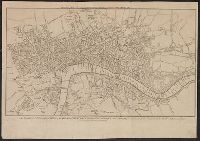
- Published / Created:
- [1780]
- Call Number:
- 32 L84 1780
- Container / Volume:
- BRBL_00048
- Image Count:
- 1
- Resource Type:
- Maps, Atlases & Globes
- Description:
- Engrav'd for Thortons New & Complete History & Survey of London & Westminster.
- Publisher:
- Alex. Hogg.,
- Subject (Geographic):
- London (England)--Maps--Early works to 1800
- Found in:
- Beinecke Rare Book and Manuscript Library > A New & Correct Plan of the Cities of London and Westminister, with the Borough of Southwark ...
7.

- Creator:
- Blodget, Samuel, 1724-1807
- Published / Created:
- February the 2d, 1756.
- Call Number:
- 771hc H864 1756
- Container / Volume:
- BRBL_00495
- Image Count:
- 1
- Resource Type:
- Maps, Atlases & Globes
- Abstract:
- Subject: Map of Hudson River from New York City to Lake George, with plans of Fort Edward and Fort William Henry. Also includes views of the first and second engagements during the Battle of Lake George. In the "First engagement" soldiers are seen shootin
- Description:
- 771hc H864 1756: Stamp "Yale Horace Brown 1900S." Accompanied by reproduction of map [with stamp "Yale Horace Brown 1900S"]. and Coordinates not present on map of Hudson River and are approximated.
- Publisher:
- Published according to act of Parliament,
- Subject (Geographic):
- Hudson River (N.Y. and N.J.)--Maps, New York (State)--Lake George, United States--History--French and Indian War, 1754-1763--Campaigns--Pictorial works, and United States--Hudson River
- Subject (Name):
- Brown, Horace--Stamp, French and Indian War (United States : 1754-1763), Jefferys, Thomas, -1771, engraver, and Lake George, Battle of (New York : 1755)
- Subject (Topic):
- Lake George, Battle of, N.Y., 1755--Pictorial works
- Found in:
- Beinecke Rare Book and Manuscript Library > A Prospective view of the battle fought near Lake George, on the 8th of Sepr. 1755 : between 2000 English, with 250 Mohawks, under the command of Gen. Johnson: & 2500 French & indians under the command of Genl. Dieskau in which the English were victorious
8.
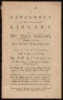
- Creator:
- Langford, Mr. (Abraham), 1711-1774.
- Published / Created:
- [1776]
- Call Number:
- X348 L264 1776
- Image Count:
- 14
- Description:
- Signatures: A⁴ B⁴ (-B4). and Stamp: College of Arms.
- Publisher:
- Catalogues of which may be had gratis on the days of viewing, at Mess. Langford aforesaid,
- Subject (Name):
- Colebrook, Josiah--Library--Catalogs. and College of Arms (Great Britain) Stamp.
- Subject (Topic):
- Catalogs, Booksellers'--England--London--Early works to 1800.
- Found in:
- Beinecke Rare Book and Manuscript Library > A catalogue of the valuable library of Mr. Josiah Colebrook, deceased : F.R.S. and late treasurer of the Antiquarian Society, which ... will be sold by auction, by Mess. Langford ... on Tuesday the 20th of this instant February 1776, and the two following evenings ...

- Published / Created:
- [1783?]
- Call Number:
- 70 1783A
- Container / Volume:
- BRBL_00356
- Image Count:
- 3
- Resource Type:
- Maps, Atlases & Globes
- Alternative Title:
- Chart comprizi, Chart containing part of the Icy Sea with the adjacent coast of Asia and America., North America and the West Indies, with the opposite coasts of Europe and Africa., and South America with the adjacent islands in the Southern Ocean and South Sea.
- Description:
- "Publish'd according to act of Parliament, 10 June 1775, by Robt. Sayers & J. Bennett, No. 53 in Fleet Street." and Chart containing part of the Icy Sea with the adjacent coast of Asia and America -- Chart comprizing Greenland with the countries and islands a
- Publisher:
- Robt. Sayer & J. Bennett,
- Subject (Geographic):
- America--Discovery and exploration--Maps--Early works to 1800 and America--Maps--Early works to 1800
- Subject (Name):
- Green, John, d. 1757, Jefferys, Thomas, d. 1771, and Robert Sayer and John Bennett (Firm)
- Found in:
- Beinecke Rare Book and Manuscript Library > A chart of North and South America : including the Atlantic and Pacific Oceans, with the nearest coasts of Europe, Africa and Asia : according to the preliminary articles of peace signed at Versailles, 20 Jany. 1783.
10.

- Published / Created:
- [1783?]
- Call Number:
- 70 1775
- Container / Volume:
- BRBL_00686
- Image Count:
- 3
- Resource Type:
- Maps, Atlases & Globes
- Alternative Title:
- Chart comprizing Greenland with the countries and islands about Baffins Bay and part of Hudsons Bay., Chart containing part of the Icy Sea with the adjacent coast of Asia and America., and Chart containing the coasts of California, New Albion, and Russian disco
- Description:
- "Publish'd according to act of Parliament, 10 June 1775, by Robt. Sayers & J. Bennett, No. 53 in Fleet Street.", Chart containing part of the Icy Sea with the adjacent coast of Asia and America -- Chart comprizing Greenland with the countries and islands about Baffins Bay and part of Hudsons Bay -- Chart containing the coasts of California, New Albion, and Russian discoveries to the north ... -- North America and the West Indies, with the opposite coasts of Europe and Africa -- Chart containing the greater part of the South Sea to the south of the line, with the islands dispersed thro' the same -- South America with the adjacent islands in the Southern Ocean and South Sea., Includes text, historical and geographical notes, ill. of ships, and tables of comparative astronomical observations., Individual sheets marked I-VI below neat line at right., Possibly from Thomas Jefferys' American atlas., Prime meridian: London and Ferro., Relief shown pictorially., Sheets pasted together to make 3 maps. Sheets measure 55 x 116.5 cm. or smaller. Cross Collection nos. 67 and 136., Shows nautical exploration routes., and Title from sheets 1 and 2.
- Publisher:
- Robt. Sayer & J. Bennett,
- Subject (Geographic):
- America--Discovery and exploration--Maps--Early works to 1800 and America--Maps--Early works to 1800
- Subject (Name):
- Green, John, d. 1757, Jefferys, Thomas, d. 1771, and Robert Sayer and John Bennett (Firm)
- Found in:
- Beinecke Rare Book and Manuscript Library > A chart of North and South America : including the Atlantic and Pacific Oceans, with the nearest coasts of Europe, Africa and Asia : according to the preliminary articles of peace signed at Versailles, 20 Jany. 1783.