"Surveyed in 1909 and 1913 ; topography by Alaskan Branch, R.H. Sargent, topographic engineer.", Includes regional location map., and Relief shown by contours and spot heights.
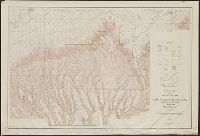
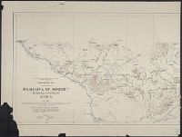
"R.B. Marshall, chief geographer. Sledge Tatum, geographer in charge. Topography by R.W. Berry and C.A. Ecklund. Control by C.F. Urquhart, M.R. McDanal, and R.M. Copeland.", "Surveyed in 1910-11.", and Includes inset showing "Railroad lines leading to Mesa Verde National Park."
Publisher:
U.S. Geological Survey,
Subject (Geographic):
Mesa Verde National Park (Colo.)--Maps
Subject (Name):
Berry, R. W, Copeland, R. M, Ecklund, C. A, Marshall, R. B. (Robert Bradford), 1867-1949, McDanal, M. R, Tatum, Sledge, and Urquhart, C. F
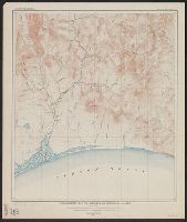
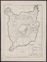
Maniema-Kivu district, Belgian Congo, Africa and Portion of Maniema-Kivu district, Belgian Congo, Africa
Description:
At head of title: "Forminiere Expedition 1907-1909, S.H. Ball, chief of party." and Imperfect: two sheets formed by center fold tear.
Publisher:
s.n.,
Subject (Geographic):
Congo (Democratic Republic)--Maps
Subject (Name):
Ball, Sydney H. (Sydney Hobart), Reid, A.E.H, Reid, C.H, Shaler, M. K. (Millard K.), Smith, A.F, and Société internationale forestière et minière du Congo
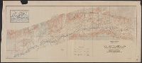
In two sheets., Includes inset of The Hawaiian Islands., and Relief shown by contours and spot heights; contour interval 40 ft.
Publisher:
Dept. of the Interior, U.S. Geological Survey,
Subject (Geographic):
Hawaii--Oahu and Oahu (Hawaii)--Maps
Subject (Name):
Birdseye, C. H. (Claude Hale), 1878-1941, Davis, Geo. R. (George R.), Fowler, A. T, Hawaii. Territorial Survey., Marshall, R. B. (Robert Bradford), 1867-1949, and U.S. Coast and Geodetic Survey