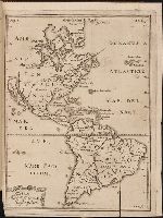
Kort beskrifning om provincien Nya Swerige uti America : som nu foertjden af the Engelske kallas
Image Count:
1
Description:
Preceding p. 1. and Teaching resource: Professor John Mack Faragher, History 141: The American West.
Subject (Geographic):
Canada --Discovery and exploration, South America --Discovery and exploration, United States --Discovery and exploration, and Western Hemisphere --Maps --Early works to 1800
Collection Created:
Stockholm : Tryckt uti Kongl. boktr. hos S. Wankijfs ankia, med egen bekostnad, af J. H. Werner, 1702
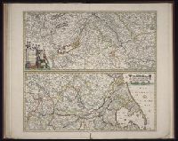
[Atlas factice of 50 maps, primarily by Johann Baptist Homann and/or issued by the Homann Erben
Image Count:
1
Alternative Title:
Cours de Danube
Publisher:
Cura Homannianorum Heredum, C.P.S.C.M
Subject (Geographic):
Balkan Peninsula --Maps --Early works to 1800, Danube River Valley --Maps --Early works to 1800, Europe, Central --Maps --Early works to 1800, and Europe, Southern --Maps --Early works to 1800
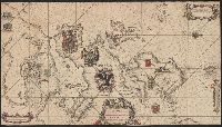
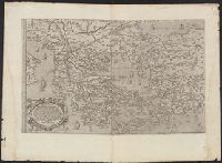
Covers Greece and western Turkey., Includes text, ill., Relief shown pictorially., Sheet measures 54 x 75 cm., Shows locations mentioned in Herodotus, Thucydides, etc., and Some place names in Latin and Greek.
Publisher:
[F. Bertelli?],
Subject (Geographic):
Greece--Historical geography--Maps--Early works to 1800, Greece--Maps--Early works to 1800, Thrace, Eastern (Turkey)--Historical geography--Maps--Early works to 1800, and Thrace, Eastern (Turkey)--Maps--Early works to 1800