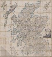
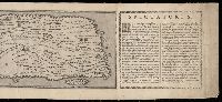
Scotland drawn and engraved from a series of angles and astronomical observations
Description:
Title from cartouche., Engraved throughout., Relief shown by contour lines and pictures., Scale of miles 69 1/2 to a degree., Another imprint: "Published according to Act of Parliament Jan. 1st. 1789 by John Ainslie ... and William Faden ..." at bottom of sheet., Inset maps: "Shetland Islands laid down upon a less scale than the map ... "; "A Map of the Orkney Islands ...", Distance tables and lists of heights of hills and roads from Edinburgh to London., Edinburgh meridian, with note of degrees from Greenwich., Title cartouche shows men fishing and herding cattle, with sheep goats and foliage., Six compass roses., This issue not in Chubb, T. Printed maps in the atlases of Great Britain and Ireland., and Scotland.
Publisher:
Printed and sold by the proprietor Thomas Brown, North Bridge Street, Edinburgh and Publish'd according to Act of Parliament with improvements till 1800 by Thomas Brown ... Edinburgh and William Faden ... London
Subject (Geographic):
Scotland, Orkney (Scotland), Shetland (Scotland), Scotland., Orkney., and Shetland.
BEIN BrSides Zc35 908un: Holes punched in margins.
Publisher:
Dept. of the Interior, General Land Office, Andrew B. Graham Co.)
Subject (Geographic):
Cheyenne River Indian Reservation (S.D.), Standing Rock Indian Reservation (N.D. and S.D.), South Dakota, Cheyenne River Indian Reservation., United States, and Standing Rock Indian Reservation.
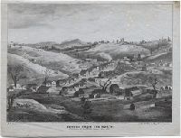
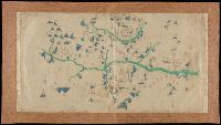
Goddard, George H. (George Henry), 1817-1906, artist
Published / Created:
May 1853.
Call Number:
WA Prints 391
Image Count:
1
Resource Type:
cartographic image
Description:
BEIN copy 1: Foxed with fading. On sheet 21 x 26 cm., BEIN copy 2: Foxed. On sheet 21 x 26 cm., Coordinates not present on map and are approximated., and Relief shown pictorially.
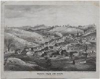
Goddard, George H. (George Henry), 1817-1906, artist
Published / Created:
May 1853.
Call Number:
WA Prints 432
Image Count:
1
Resource Type:
cartographic image
Description:
BEIN WA Prints 432 copy 1: On sheet: 23 x 28 cm., BEIN WA Prints 432 copy 2: Imperfect: Foxed, with some fading. On sheet: 21 x 27 cm., Relief shown pictorially., and Coordinates not present on map and are approximated.
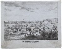
Peutinger table and Tabvla itineraria ex illvstri Pevtingerorvm Bibliotheca
Description:
BEIN 2016 +333: Imperfect: title panel mutilated, with some loss of text. Sheets joined together to form a roll; backed in linen., Relief shown pictorially., "MD" in publication date in apostrophic forms., Appears in Ortelius' Theatri Orbis Terrarum Parergon. Antwerp, 1624., and "Peutinger Table: Road map of Western Roman Empire about 250 A.D. bought by Conrad Peutinger and published in Venice by Aldus in 1591 (2 sections only), in Antwerp 1598 (12 sections) ... The only record of Roman map making that has survived to the present day."--Tooley's Dictionary of Mapmakers. New York, 1979.
Bankoku ichiranzu, Bankoku ichiran zusetsu, and (Explanation of the visualized map of all the countries)
Description:
BEIN 2018 +512: Manuscript annotations in English on margins of map., Cover attached; cover and map title the same., Accompanied by: BANKOKU ICHIRAN ZUSETSU : (Explanation of the visualized map of all the countries) / Koyano Yoshiharu. -- Bunka 7 : (1810). -- 2 v., ill. ; 25.2 x 18 cm., Kôzanrō is a private school of Koyano Yoshiharu., and California shown as an island.
Publisher:
Kôzanrô, (June, 1809)
Subject (Geographic):
Japan and Japan.
Subject (Topic):
World maps, Geography, Study and teaching, and Prints, Japanese