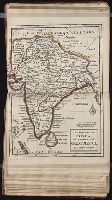
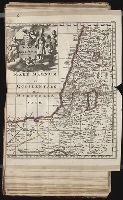
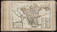
Twenty four new and accurate maps of the several parts of Europe ... : all (except the last) new
Image Count:
1
Alternative Title:
Turkey in Europe
Description:
In pencil on verso: 24. and Table of contents for maps 20-24 misnumbered.
Subject (Geographic):
Turkey --Maps
Subject (Name):
Barker, B. (Benjamin), d. 1764, bookseller, Clements, Henry, d. 1719, bookseller, King, Charles, d. 1735, bookseller, Nicholson, John, d. ca. 1717, bookseller, Parker, Richard, fl. 1692-1725, bookseller, and Tooke, Benjamin, d. 1716, bookseller
Subject (Topic):
Atlases --Early works to 1800
Collection Created:
[London] : Sold by J. Nicholson at the King’s-Arms in Little Britain, Benj. Barker and Charles King ..., Benj. Tooke ..., Hen. Clements ..., R. Parker and Ralph Smith under the Royal-Exchange ..., [1715?]
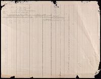
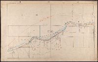
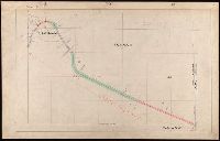
107 colored manuscript railroad maps, detailing the line of the Colorado Midland Railway between Park County and Pitkin and Garfield Counties. The highly detailed maps depict county ranges and townships, survey points and mileage markers, depots, canyons, bridges, sidings, trestles, tunnels, rivers, creeks, etc.; adjacent railroad lines and rights-of-way; hamlets, villages, settlements, ranches, farms, etc.; and plats of the towns of Buena Vista, Leadville, Glenwood Springs, and Aspen. Counties covered are Chaffee, Eagle, Garfield, Lake, Park, and Pitkin. Accompanied by an incomplete index (1 leaf) entitled "Valuation Section [?] Colo. Midland Ry" and two leaves of surveying notes.
Description:
Versos blank, not digitized.
Subject (Geographic):
Colorado--Maps and Garfield County (Colo.)--Maps
Subject (Name):
Colorado Midland Railway Company
Subject (Topic):
Mines and mineral resources--Colorado--Maps and Railroads--Colorado--Maps