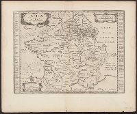
Atlas novus. and Gallia vetus ad Julij Caesaris commentaria
Description:
Latin text on recto; Dutch text on verso., Lower left corner: "Amstelodami apud Ioannem Ianβonium.", Published in Dutch editions of Jansson's Atlas novus (Dutch title: Nieuwen atlas, ofte vveerelts-beschrijvinge), vol. 6, ca. 1662, and Relief shown pictorially.
Publisher:
Jan Jansson,
Subject (Geographic):
France--History--To 987--Maps--Early works to 1800 and Gaul--Maps--Early works to 1800
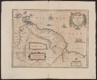
Gviana siue Amazonvm regio and Gviana sive Amazonvm regio
Description:
Bar scales in "Milliaria Germanica communia" and "Milliaria Gallica communia.", From Jansson's Nieuwen atlas of 1647 or 1658., Hand col. Sheet measu, In Dutch on verso, with caption title "Guiana oft de wilde Kust" and signature 2N., and Relief shown pictorially.
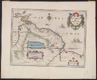
Gviana siue Amazonvm regio and Gviana sive Amazonvm regio
Description:
Bar scales in "Milliaria Germanica communia" and "Milliaria Gallica communia.", From Jansson's Atlantis co, Hand col. Sheet measures 50.8 x 62 cm., In Latin on verso, with caption title "Guiana sive regio Amazonum" and no signature., and Relief shown pictorially.
Appeared in various editions of Jan Jansson's Accuratissima orbis antiqui delineatio., Includes four bar scales., Relief shown pictorially., Verso blank., and Watermark. Manuscript number in upper left corner: 25.
Publisher:
[Jan Jansson],
Subject (Geographic):
Greece--Maps--Early works to 1800.
Subject (Name):
Jansson, Jan, 1588-1664. Accuratissima orbis antiqui delineatio.
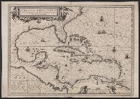
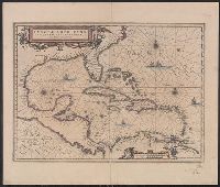
Insulae Americanae in Oceano Septentrionali cum terris adjacentibus and Insvlae Americanae in Oceano Septentrionali cum terris adiacentibus
Description:
Includes embellished title cartouche, dedication with coats-of-arms, scale and ill. of ships at sea., No text on verso., Sheet measures 40.1 x 56.8 cm. Ms. notes on verso. Stamp on verso: T.W. Streeter., and Shows southeast coast of North America from Virginia to north coast of South America to east of Trinidad, west coast of Central America, West Indies.
Publisher:
Apud Ioannem Ianssonium,
Subject (Geographic):
Caribbean Area--Maps--Early works to 1800, Mexico, Gulf of--Maps--Early works to 1800, and West Indies--Maps--Early works to 1800
Subject (Name):
Streeter, Thomas W.--(Thomas Winthrop),--1883-1965--Stamp
Subject (Topic):
Coasts--North America--Maps--Early works to 1800 and Coasts--South America--Maps--Early works to 1800
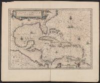
Insulae Americanae in Oceano Septentrionali cum terris adjacentibus and Insvlae Americanae in Oceano Septentrionali cum terris adiacentibus
Description:
Appears in various Dutch eds. of Jansson's Nieuwen atlas., Includes scales in milliaria germanica and mill, and Shows southeast coast of North America from Virginia to north coast of South America to east of Trinidad, west coast of Central America, West Indies.
Publisher:
Apud Ioannem Ianssonium,
Subject (Geographic):
Caribbean Area--Maps--Early works to 1800, Mexico, Gulf of--Maps--Early works to 1800, and West Indies--Maps--Early works to 1800
Subject (Name):
Jansson, Jan, 1588-1664. Atlas novus. Dutch
Subject (Topic):
Coasts--North America--Maps--Early works to 1800 and Coasts--South America--Maps--Early works to 1800
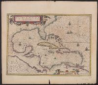
Insulae Americanae in Oceano Septentrionali cum terris adjacentibus and Insvlae Americanae in Oceano Septentrionali cum terris adiacentibus
Description:
Appears in various French eds. of Jansson's Nouvel atlas., Includes embellished title cartouche, dedication with coat, Includes scales in milliaria germanica and milliaria hispanica., and Mounted on linen. Sheet measures 49.8 x 58.6 cm. Cross Collection no. 233.
Publisher:
Apud Ioannem Ianssonium,
Subject (Geographic):
Caribbean Area--Maps--Early works to 1800, Mexico, Gulf of--Maps--Early works to 1800, and West Indies--Maps--Early works to 1800
Subject (Name):
Jansson, Jan, 1588-1664. Atlas novus. French
Subject (Topic):
Coasts--North America--Maps--Early works to 1800 and Coasts--South America--Maps--Early works to 1800
Insulae Americanae in Oceano Septentrionali cum terris adjacentibus and Insvlae Americanae in Oceano Septentrionali cum terris adiacentibus
Description:
From Jansonius's and Hondius's Atlas novus ... Amstelodami : Apud Ionnem Ianssonium & Henricum Hondium, 1638., Includes scales in milliaria germanica and leucae hispanicae., and Show southeast coast of North America from Virginia to north coast of South America to east of Trinidad, west coast of Central America, West Indies.
Publisher:
Apud Ioannem Ianssonium,
Subject (Geographic):
Caribbean Area--Maps--Early works to 1800, Mexico, Gulf of--Maps--Early works to 1800, and West Indies--Maps--Early works to 1800
Subject (Name):
Hondius, Hendrik, 1597-1651. Atlas novus and Jansson, Jan, 1588-1664. Atlas novus
Subject (Topic):
Coasts--North America--Maps--Early works to 1800 and Coasts--South America--Maps--Early works to 1800
Insulae Americanae in Oceano Septentrionali cum terris adjacentibus and Insvlae Americanae in Oceano Septentrionali cum terris adiacentibus
Description:
From Jansonius's and Hondius's Atlas novus ... Amstelodami : Apud Ionnem Ianssonium & Henricum Hondium, 1638., Includes embellished title cartouche, scale and ill. of ships at sea., Sheet measures 49 x 57.8 cm. Cross Collection no. 234., and Text in Latin on verso with running title "Hispaniola & Cuba, caption title "Insulae Americae praecipuae sunt Hispaniola et Cuba," and signature 4U.
Publisher:
Apud Ioannem Ianssonium,
Subject (Geographic):
Caribbean Area--Maps--Early works to 1800, Mexico, Gulf of--Maps--Early works to 1800, and West Indies--Maps--Early works to 1800
Subject (Name):
Hondius, Hendrik, 1597-1651. Atlas novus and Jansson, Jan, 1588-1664. Atlas novus
Subject (Topic):
Coasts--North America--Maps--Early works to 1800 and Coasts--South America--Maps--Early works to 1800