Cross Collection no. 245., Imperfect: map of Jamaica cut-out. Two maps (Antigua and Barbados)., Includes explanatory notes and index., Relief shown pictorially., Scales in millaria Anglica communia and/or millaria Anglica statuta., and Sheet title in Latin and German. Individual map titles and text in German. Maps in English and German.
Publisher:
Homann Erben,
Subject (Geographic):
Antigua--Maps--Early works to 1800, B, Barbados--Maps--Early works to 1800, Jamaica--Maps--Early works to 1800, Saint Kitts and Nevis--Maps--Early works to 1800, and West Indies--Maps--Early works to 1800
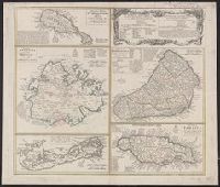
Cross Collection no. 253., Includes explanatory notes and index., Ms. notes in upper right corner., Relief shown pictorially., Scales in millaria Anglica communia and/or millaria Anglica statuta., Sheet title in Latin and German. Individual map titles and text in German. Maps in English and German., and Three maps (Antigua, Barbados, Jamaica). Mounted on linen.
Publisher:
Homann Erben,
Subject (Geographic):
Antigua--Maps--Early works to 1800, Barbados--Maps--Early works to 1800, Bermuda Islands--Maps--Early works to 1800, Jamaica--Maps--Early works to 1800, and Saint Kitts and Nevis--Maps--Early works to 1800
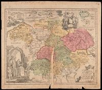
Imperfect: mutilated along fold, with some loss of text; chipped. Manuscript number in upper right corner: 4. From the Karpinski-von Wieser Map Collection., Includes illustration and inset: Appendix monasteriorum Ord. S. Bened. quae extant in Polonia et Lithuania., Relief shown pictorially., and Shows location of Benedictine monasteries in Holy Roman Empire, Poland, and Lithuania.
Publisher:
[Homann Erben]
Subject (Geographic):
Europe, Central and Germany
Subject (Topic):
Benedictine monasteries--Europe, Central--Maps--Early works to 1800, Benedictine monasteries--Germany--Maps--Early works to 1800, Monasteries--Europe, Central--Maps--Early works to 1800, and Monasteries--Germany--Maps--Early w
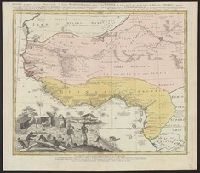
Guinea propria, nec non Nigritiæ vel Terræ Nigrovrm maxima pars, Guinee de meme que la plus grande partie du Pais des Negres, and Gvinee de meme que la plus grande partie du Pais des Negres
Description:
Covers West Africa from Gabon in the south to Niger, Mali, and Mauritania in the north., Has watermark., Includes indexed ill. depicting the dress, dwellings, and work of native Africans., Prime meridian: Ferro., and Relief shown pictorially.
Publisher:
Homannianorum Heredum,
Subject (Geographic):
Africa, West--Maps--Early works to 1800
Subject (Name):
Anville, Jean Baptiste Bourguignon d', 1697-1782 and Marchais, R. de
"Cum privil. S. Caes. M.", Includes inset view of "St. Petersburg," ornamental cartouche, and text., and Verso: Stamped "Yale Univ. Lib. Map Coll. Nov 21 1975". Lada-Mocarski Collection.
Publisher:
Homann heirs,
Subject (Geographic):
Ingria (Russia)--Maps--Early works to 1800 and Saint Petersburg Region (Russia)--Maps--Early works to 1800
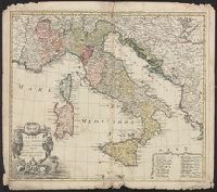
Gli stati d'Italia secondo le osservationi fatte dalla Societa di Se di Parigi, dal R.P. Riccioli della S. die Giesu ed. altri astronomi, di prima geograficamente delineati ... Sgr. de l'Isle ... alle spese degl' heredi d'Homann l'Anno MDCCXLII
Description:
Includes 14 bar scales., Relief shown pictorially., and Sheet measures 54.5 x 61.2 cm.
Publisher:
Curantibus Homannianis Heredibus,
Subject (Geographic):
Italy--Maps--Early works to 1800
Subject (Name):
L'Isle, Guillaume de, 1675-1726 and Riccioli, Giovanni Battista, 1598-1671
Iimage of the Saints Maurus and Placid surrounded by angels in lower left corner., Publisher statement precedes place of publication in imprint., Relief shown pictorially., and Watermark. Manuscript number in right corner: 42. From the Karpinski-von Wieser Map Collection.
Publisher:
Excusa per Haeredes Homan[n]ianos
Subject (Geographic):
Italy--Maps--Early works to 1800.
Subject (Name):
Benedictines and Benedictines--Italy--Maps--Early works to 1800
Subject (Topic):
Ecclesiastical geography and Ecclesiastical geography--Italy--Maps--Early works to 1800.
Homann Erben (Firm) Homann, Johann Baptist, 1663-1724
Published / Created:
ca. 1730]
Call Number:
319 1720
Container / Volume:
BRBL_00040
Image Count:
1
Resource Type:
Maps, Atlases & Globes
Alternative Title:
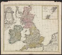
General map of Great Britain and Ireland with part of Holland, Flanders France &c. agreable to modern history by the heirs of late Mr. Homann at Nuremburg
Description:
Graphic scales given in "mill. Anglica" and "milliaria Germ.", Inset, top right: Orcades insulae ... Schetlandicae., Ornate title cartouche, top left, depicting coat of arms and flags., Relief shown pictorially., and Sheet measures 54.5 x 61.9 cm.
Publisher:
Homann Erben,
Subject (Geographic):
Great Britain--Maps--Early works to 1800 and Ireland--Maps--Early works to 1800