Skip to search
Skip to main content
Skip to first result
Search
You Searched For
Resource Type
Maps, Atlases & Globes
New Search
Search Results
Creator:
Published / Created:
1912
Call Number:
739 1912R
Container / Volume:
BRBL_00388
Image Count:
4
Resource Type:
Maps, Atlases & Globes
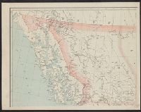
Description:
Shows roads, 3 classes of boundaries, spot hts., 5 major classes of railroads and insets: Sketch map of the world -- Dominion of Canada.
Publisher:
B.C.]. Dept. of Lands,
Subject (Geographic):
British Columbia--Maps
Subject (Name):
Aitken, G. G
Found in:
Beinecke Rare Book and Manuscript Library > British Columbia / G.G. Aitken, chief geographer.
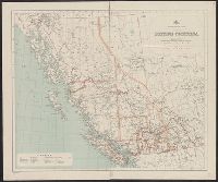
Published / Created:
1909
Call Number:
739gme 1909
Container / Volume:
BRBL_00393
Image Count:
1
Resource Type:
Maps, Atlases & Globes
Description:
"Rand, McNally & Co.'s New Business Atlas Map of British Columbia.", Includes inset map: Northern part of British Columbia., and Index to railways overprinted in red in lower right; index to cities by population in left margin.
Publisher:
Rand McNally & Co., Map Publishers and Engravers,
Subject (Geographic):
British Columbia--Maps
Found in:
Beinecke Rare Book and Manuscript Library > British Columbia [Railroads].
Creator:
Published / Created:
1913
Call Number:
739 1913B
Container / Volume:
BRBL_00388
Image Count:
1
Resource Type:
Maps, Atlases & Globes
Description:
Relief shown by spot heights.
Publisher:
Dept. of Lands,
Subject (Name):
Aitken, G. G
Subject (Topic):
Public lands--British Columbia--Maps
Found in:
Beinecke Rare Book and Manuscript Library > British Columbia land districts.
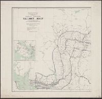
Creator:
Published / Created:
1908
Call Number:
739 1908
Container / Volume:
BRBL_00388
Image Count:
2
Resource Type:
Maps, Atlases & Globes
Description:
"Corrected to February 1st, 1908.", Indicates "lands disposed of, also timber berths.", Inset: Vancouver Island (Scale [ca. 1:1,267,200])., and Relief shown by spot heights.
Publisher:
The Department,
Subject (Geographic):
British Columbia--Maps
Subject (Name):
White, James, 1863-1928 and Young, R. E
Subject (Topic):
Railroads--British Columbia--Maps
Found in:
Beinecke Rare Book and Manuscript Library > British Columbia railway belt / Dept. of the Interior ; prepared under the direction of R.E. Young, Superintendent of Railway and Swamp Lands ; James White, F.R.G.S., geographer.
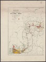
Creator:
Published / Created:
1907
Call Number:
739G 1907
Container / Volume:
BRBL_00392
Image Count:
2
Resource Type:
Maps, Atlases & Globes
Description:
"Corrected to July 1st, 1907.", Indicates "lands disposed of, also timber berths.", and Relief shown by spot heights.
Publisher:
The Department,
Subject (Geographic):
British Columbia--Maps
Subject (Name):
White, James, 1863-1928 and Young, R. E
Subject (Topic):
Railroads--British Columbia--Maps
Found in:
Beinecke Rare Book and Manuscript Library > British Columbia railway belt / Dept. of the Interior; prepared under the direction of R.E. Young, Superintendent of Railway and Swamp Lands; James White, F.R.G.S., geographer.
Branch:v1.61.6 ,Deployed:2024-06-12T09:55:37-04:00