
You Searched For
1 - 9 of 9
Search Results

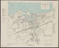
2.

- Creator:
- Great Britain. Inter-service Topographical Dept
- Published / Created:
- 1943, 1944 printing.
- Call Number:
- 38 D742 1944
- Container / Volume:
- BRBL_00157
- Image Count:
- 1
- Resource Type:
- Maps, Atlases & Globes
- Alternative Title:
- France 1:4,000, Geographical Section, General Staff ; no. 4234, and GSGS (Series) ; 4234.
- Description:
- "1-44.", "AMS 1.", "Grid provisional, Lambert zone I grid.", "War Office 1943.", A few important streets and buildings are named; areas exposed at low tide are indicated., Major street names and buildings in French., and Relief show by rock drawings.
- Publisher:
- Army Map Service, U.S. Army, and War Office ;
- Subject (Geographic):
- Douarnenez (France)--Maps and Tréboul (France)--Maps
- Found in:
- Beinecke Rare Book and Manuscript Library > Douarnenez-Tréboul [cartographic material] : plan of port and town / compiled and drawn by Inter-Service Topographical Dept. ; produced under the Superintendence of Vice-Admiral John Edgell, hydrographer.
- Creator:
- Great Britain. Inter-service Topographical Dept
- Published / Created:
- 1943
- Call Number:
- 38 D92 1943
- Container / Volume:
- BRBL_00157
- Image Count:
- 1
- Resource Type:
- Maps, Atlases & Globes
- Alternative Title:
- France 1:10,000, Geographical Section, General Staff ; no. 4234, and GSGS (Series) ; 4234.
- Description:
- "8-43.", "AMS 2.", "Grid provisional, Nord de Guerre zone grid.", "War Office 1943.", Important streets are named; list of important buildings, industries and port facilities in margin., and Major streets and buildings in French.
- Publisher:
- Army Map Service, U.S. Army, and War Office ;
- Subject (Geographic):
- Dunkerque (France)--Maps
- Found in:
- Beinecke Rare Book and Manuscript Library > Dunkerque [cartographic material] : plan of port & town / compiled and drawn by Inter-Service Topographical Dept. ; produced under the Superintendence of Vice-Admiral John Edgell, hydrographer.

- Creator:
- Great Britain. Inter-service Topographical Dept
- Published / Created:
- 1943, 1944 printing.
- Call Number:
- 38 F31 1944
- Container / Volume:
- BRBL_00157
- Image Count:
- 1
- Resource Type:
- Maps, Atlases & Globes
- Alternative Title:
- France 1:5,000, Geographical Section, General Staff ; no. 4234, and GSGS (Series) ; 4234.
- Description:
- "1-44.", "First G.S.G.S. ed., 1943.", "Grid provisional. Nord de Guerre zone grid.", "War Office 1943.", Important street names, industries and port facilities are shown., Includes index., Major street names, some buildings, and sites in French., and Relief shown by
- Publisher:
- Army Map Service, U.S. Army, and War Office ;
- Subject (Geographic):
- Fécamp (France)--Maps
- Found in:
- Beinecke Rare Book and Manuscript Library > Fécamp, plan of port and town [cartographic material] / compiled and drawn by Inter-Service Topographical Dept. ; produced under the Superintendence of Vice-Admiral John Edgell, hydrographer.
5.
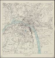
- Creator:
- United States. Army Map Service
- Published / Created:
- 1943
- Call Number:
- 38 R75 1943
- Container / Volume:
- BRBL_00165
- Image Count:
- 1
- Resource Type:
- Maps, Atlases & Globes
- Alternative Title:
- France 1:12,500 and Series M961
- Description:
- "3-43.", "Copied from a French map, 1:10,000, Plan de la ville de Rouen, 1933.", "First edition 1943.", Most streets and some buildings are named., Nord de guerre zone grid., and Street names and some points of interest in French.
- Publisher:
- Army Map Service, U.S. Army,
- Subject (Geographic):
- Rouen (France)--Maps
- Found in:
- Beinecke Rare Book and Manuscript Library > Rouen, city plan [cartographic material] / prepared under the direction of the Chief of Engineers, U.S. Army, 1943.
6.
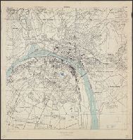
- Creator:
- United States. Army Map Service
- Published / Created:
- 1943
- Call Number:
- 38 R75 1943
- Container / Volume:
- BRBL_00165
- Image Count:
- 1
- Resource Type:
- Maps, Atlases & Globes
- Alternative Title:
- France 1:12,500 and Series M961
- Description:
- "3-43.", "Copied from a French map, 1:10,000, Plan de la ville de Rouen, 1933.", "First edition 1943.", Most streets and some buildings are named., Nord de guerre zone grid., and Street names and some points of interest in French.
- Publisher:
- Army Map Service, U.S. Army,
- Subject (Geographic):
- Rouen (France)--Maps
- Found in:
- Beinecke Rare Book and Manuscript Library > Rouen, city plan [cartographic material] / prepared under the direction of the Chief of Engineers, U.S. Army, 1943.

- Creator:
- Great Britain. Inter-service Topographical Dept
- Published / Created:
- 1943, 1944 printing.
- Call Number:
- 38 R81 1944
- Container / Volume:
- BRBL_00165
- Image Count:
- 1
- Resource Type:
- Maps, Atlases & Globes
- Alternative Title:
- France 1:7,350, Geographical Section, General Staff ; no. 4234, GSGS (Series) ; 4234., and Royan, plan of town
- Description:
- "First A.M.S. ed., 1943.", "First G.S.G.S. ed., 1943.", "Grid provisional. Lambert (zone II) grid.", "I-44.", "War Office 1943.", Important streets are named; key to points of interest in margin., and Major street names and some buildings in French.
- Publisher:
- Army Map Service, U.S. Army, and War Office ;
- Subject (Geographic):
- Royan (France)--Maps
- Found in:
- Beinecke Rare Book and Manuscript Library > Royan [cartographic material] : plan of town / compiled and drawn by Inter Service Topographical Dept. ; produced under the Superintendence of Vice-Admiral John Edgell, hydrographer.
- Creator:
- Great Britain. Inter-service Topographical Dept
- Published / Created:
- 1943, 1944 printing.
- Call Number:
- 38 Sa233 1944
- Container / Volume:
- BRBL_00165
- Image Count:
- 1
- Resource Type:
- Maps, Atlases & Globes
- Alternative Title:
- France 1:6,000, Geographical Section, General Staff ; no. 4234, GSGS (Series) ; 4234., Saint Malo, and St. Malo, plan of port and town
- Description:
- "G.S.G.S. edition, 1943.", "Grid provisional. Lambert zone I grid.", "I-44.", "War Office, 1943.", Principal street names, important buildings and port facilities are indicated., Relief shown by rock drawings., and Street names and some places of interest in French
- Publisher:
- Army Map Service, U.S. Army, and War Office ;
- Subject (Geographic):
- Saint-Malo (France)--Maps
- Found in:
- Beinecke Rare Book and Manuscript Library > St. Malo [cartographic material] : plan of port and town / compiled and drawn by Inter-Service Topographical Dept. ; produced under the Superintendence of Vice-Admiral John Edgell, hydrographer.

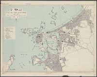
- Creator:
- United States. Army Map Service
- Published / Created:
- 1943
- Call Number:
- 38 Sa24 1943
- Container / Volume:
- BRBL_00165
- Image Count:
- 1
- Resource Type:
- Maps, Atlases & Globes
- Alternative Title:
- France 1:5,000, Saint Nazaire, and Series M961
- Description:
- "4-43.", "Copied from CB 1804, map 27.", "French Lambert zone II grid.", Major street names and place names in French., Relief shown by rock drawings., and Some streets and buildings are named.
- Publisher:
- Army Map Service, U.S. Army,
- Subject (Geographic):
- Saint-Nazaire (France)--Maps
- Found in:
- Beinecke Rare Book and Manuscript Library > St. Nazaire, city plan [cartographic material] / prepared under the direction of the Chief of Engineers, U.S. Army, Washington, D.C.