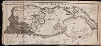
Bellin, Jacques Nicolas, 1703-1772, creator France, Depot des cartes et plans de la marine
Published / Created:
1759
Call Number:
2003 Folio 85
Image Count:
1
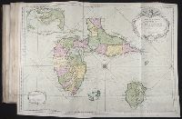
Description:
BEIN 2003 Folio 85: No. 36 of 45 maps bound together with binder's spine title: Atlas of America; ms. table of contents. Bookplate: Robinson. Bookplate of Paul Mellon., Dressee au Depost des cartes, plans et journaux de la marine. Pour le service des vaisseaux du roy. Par ordre de M. Berryer, ministre et secretaire d'Etat aiant le Department de la marine. Par le Sr. Bellin, ingenieur de la marine et du depost de plans. M.DCC.LIX., Hand colored., Inset: Environs du Fort Louis a l'entree du petit cul de sac de la Guadeloupe., Longitude occidentale du meridien de Paris., Relief shown by hachures. Depths shown by soundings., and Scale [ca. 1:200,000].
Publisher:
DeÌpost des cartes, plans et journaux de la marine
Subject (Geographic):
Guadeloupe -- Maps -- Early works to 1800 and Marie-Galante (Guadeloupe) -- Maps -- Early works to 1800
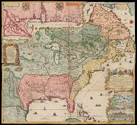
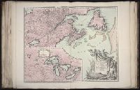
Relief shown pictorially., Title from lower right cartouche., Originally in 4 sheets., Includes text and ill., and Insets: Les costes de la Louisiane de puis la Baye de l'Ascension jusques Acelle de St. Joseph ... Scale [ca. 1:1,000,000] -- Les environs de Québec -- Veüe de Québec.
Publisher:
Chez L'Auteur
Subject (Geographic):
North America, Mississippi River Delta (La.), Gulf Coast (Miss.), Gulf Coast (Ala.), and Québec Region (Québec)
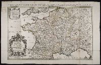
Haussard, C Robert de Vaugondy, Gilles, 1688-1766, creator
Published / Created:
1755
Call Number:
2003 Folio 85
Image Count:
1
Description:
Avec privilege 1755., BEIN 2003 Folio 85: No. 13 of 45 maps bound together with binder's spine title: Atlas of America; ms. table of contents. Bookplate: Robinson. Bookplate of Paul Mellon., C. Haussard sculp., From the author's Atlas universel. 1757[-1758]., Hand colored., Inset of Supplement pour les lacs du Canada. Scale [ca. 1:5,500,000]., par le Sr. Robert de Vaugondy, geog? ordinaire du Roy., Relief shown pictorially., and Scale [ca. 1:4,000,000].
Subject (Geographic):
Canada -- Maps -- Early works to 1800 and New France -- Maps -- Early works to 1800
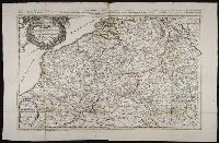
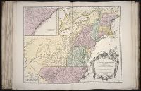
Haussard, C Robert de Vaugondy, Gilles, 1688-1766, creator
Published / Created:
1755
Call Number:
2003 Folio 85
Image Count:
1
Description:
BEIN 2003 Folio 85: No. 16 of 45 maps bound together with binder's spine title: Atlas of America; ms. table of contents. Bookplate: Robinson. Bookplate of Paul Mellon., Hand colored., Inset: Supplement pour la Caroline., M. C. Haussard fecit., par le Sr. Robert de Vaugondy, geographe ordinaire du Roi., Relief shown pictorially., and Scale [ca. 1:2,900,000]
Subject (Geographic):
Ohio River Valley -- Maps -- Early works to 1800 and United States -- Maps -- Early works to 1800
Haye, G. de la Robert de Vaugondy, Gilles, 1688-1766, creator
Published / Created:
1750
Call Number:
2003 Folio 85
Image Count:
1
Description:
BEIN 2003 Folio 85: No. 28 of 45 maps bound together with binder's spine title: Atlas of America; ms. table of contents. Bookplate: Robinson. Bookplate of Paul Mellon., Hand colored., par le Sr. Robert, geographe ordinaire du roy, avec privilege. 1750. Guill. ' Delahaye, sculpsit., Relief shown pictorially., and Scale [ca. 1:5,000,000].