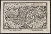
Orbis terrarvm veteribvs cogniti typvs geographicvs
Description:
Appears in Jansson's Accuratissima orbis antiqui delineatio, 1653., Dedication: "Nobilissimo amplissimo qz viro, Dno. Francisco Banningio cocq ... Iohan Ianssonius.", and Sheet measures 50 x 62 cm.
Cross collection no. 28., Includes text, two celestial insets, two insets of solstices, two panoramic views, and illustrations., and Relief shown pictorially.
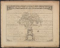
Mappe-monde qui représente les deux hemisphères savoir celui de l'orient et celui de l'occident, tirée des quatre cartes générales de feu M. le profess. Hasius, Planiglobii terrestris mappa vniversalis, and Schul-Atlas von zwantzig General- und Special-Lan
Description:
Appears in Homann heirs' Schul-atlas von zwantzig general-und special-land karten ... Cf. Phillips, no. 293., Imperfect: torn along fold, with no loss of text. Shee, Map colored to show distribution of religions., and Title in Latin and French; legend in German.
Publisher:
Homann Erben],
Subject (Name):
Hase, Johann Matthias, 1684-1742 and Homann Erben (Firm)
Subject (Topic):
Religion--Maps--Early works to 1800 and World maps--Early works to 1800
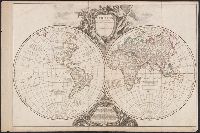
From Bonne's Atlas de toutes les parties connues du globe terrestre ... [Paris : J.L. Pellet, 1780?]., Hand col. Sheet measures 26 x 39 cm. Verso: "Projection de Mercator" in ink ms. Lada-Mocarski Collection., Meridians: Ferro, Paris., and Top left, in margin: "
Publisher:
J.L. Pellet,
Subject (Name):
Bonne, Rigobert, 1727-1794. Atlas de toutes les parties connues du globe terrestre .. and Pellet, J.-L. (Jean-Léonard), publisher
Subject (Topic):
Cartographers--France--18th century and World maps--Early works to 1800
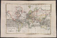
Decorated with sea monsters, mermaids, exotic animals, and cannibals, this wood cut map provides a marked contrast to the simplistic diagrams considered the earliest printed world maps. While the latter presented a world view based in Judeo-Christian theo
Alternative Title:
Typus cosmographicus universalis and Typvs cosmographicvs vniversalis
Description:
Appears in Johann Huttich's Novus orbis regionum. Basel. 1532. and Relief shown pictorially.
Publisher:
[publisher not identified],
Subject (Name):
Holbein, Hans, 1497-1543 and Huttich, Johann, 1480?-1544. Novus orbis regionum.
Possibly from Münster's 1545 edition of Ptolemy's Geographia [Basel : Heinrich Petri, 1545]. and Sheet measures 31.5 x 39 cm. Stamp on verso: Karpinski-von Wieser Map Collection.