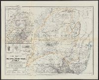
Ergänzungsheft ... zu Petermanns geographischen Mitteilungen. and Transvaal or South-African Republik
Description:
"From surveys and observations by Survr. Genl. M. Forssmann, C. Mauch, F. Hammar, Survr. J. Brooks, and other official documents, combined with the results of their own explorations by F. Jeppe and A. Merensky, Potchefstroom & Botsabelo, 1868." and In top mar
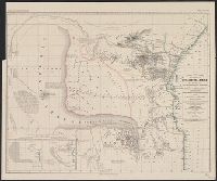
Ost-u.-Central-Afrika and Petermanns geographische Mittheilungen.
Description:
"Gestützt auf die Angaben zahlreicher Eingebornen und muhamedanischer Reisenden und zusammengetragen von Jakob Erhardt u, In top margin: Petermann's geographische Mittheilungen, Jahrgang 1856, Tafel 1., Includes 2 insets and text., and Relief shown by hachures.
Publisher:
Justus Perthes ,
Subject (Geographic):
Africa, East--Maps
Subject (Name):
Erhardt, Jakob, Justus Perthes (Firm : Gotha, Germany), and Rebmann, Johann
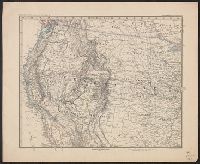
"Stieler's Hand Atlas, No. 79 ; Stieler's Hand Atlas, No. 80.", Imperfect: sheet 3-4 wanting., Inset: Atlantischen Staaten zwischen Washington & Boston, 1:2,000,000., Prime meridian: Greenwich., and Relief shown by hachures.
Publisher:
Justus Perthes,
Subject (Geographic):
United States--Maps
Subject (Name):
Habenicht, Hermann, 1844-1917 and Justus Perthes (Firm : Gotha, Germany)