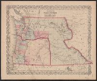
"Entered according to act of Congress in the year 1853 by J.H. Colton & Co. in the clerk's office of the district court of the United States for the southern district of New York.", Covers Washington, Oregon, and Idaho., In lower right corner: No. 53., and Prime meridians: Greenwich and Washington, D.C.
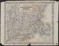
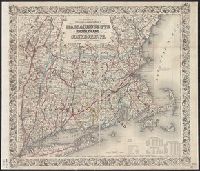
"Entered according to Act of Congress in the Year 1863 by J.H. Colton in the Clerks Office of the District Court for the Southern District of New York.", "Printed by D. Mc. Lellan, 26, and Includes tables for each state of population, farms, and manufacturing.
"Entered according to Act of Congress in the Year 1863 by J.H. Colton in the Clerks Office of the District Court for the Southern District of New York.", "Printed by D. Mc. Lellan, 26, and Includes tables for each state of population, farms, and manufacturing.
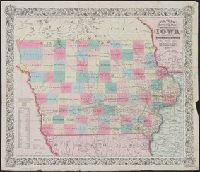
"Entered according to Act of Congress in the year 1851, by J.H. Colton in the Clerks Office of the Dist. Court for the Southn. Dist. of New York.", Includes census figures by county, Prime meridians: Greenwich and Washington., and Shows post roads and railroads.
Publisher:
J.H. Colton,
Subject (Geographic):
Iowa--Maps
Subject (Name):
Atwood, John M., b. ca. 1818 and Colton, G. Woolworth (George Woolworth), 1827-1901
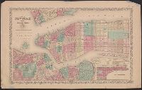
"Entered according to act of Congress in the year 1855 ...", In top margin: No. 17 ... No. 18., and Inset map: Continuation of the city & county of New York, on a reduced scale.
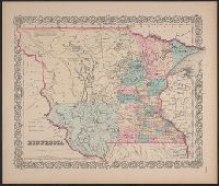
"Entered accoding [sic] to Act of Congress in the year 1855, by J.H. Colton & Co. in ... the Southern District of New York.", Covers Minnesota Territory, extending to White Earth and Missouri rivers to the west., In lower right margin: No. 49., and Includes note.
Publisher:
J. H. Colton & Co.,
Subject (Geographic):
Minnesota--Maps, North Dakota--Maps, and South Dakota--Maps
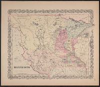
"Entered according to Act of Congress in the year 1855, by J.H. Colton & Co. ...", Covers Minnesota Territory, including Pembina, and the Yankton, Yanktonnan and Chippewa areas, with Missouri River and White Earth River as western boundary., and In bottom right margin: No. 49.
Publisher:
J.H. Colton & Co.,
Subject (Geographic):
Minnesota--Maps, North Dakota--Maps, and South Dakota--Maps
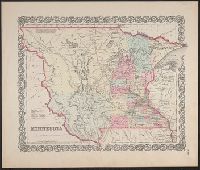
"Entered according to Act of Congress in the year 1855, by J.H. Colton & Co. ...", Appears in Colton's atlas of the world. New York: J.H. Colton & Co., 1855-56., and Covers Minnesota Territory, including Pembina, and the Yankton, Yanktonnan and Chippewa areas, with Missouri River and White Earth River as western boundary.
Publisher:
J.H. Colton & Co.,
Subject (Geographic):
Minnesota--Maps, North Dakota--Maps, and South Dakota--Maps
Subject (Name):
Colton, G. Woolworth (George Woolworth), 1827-1901. Colton's atlas of the world