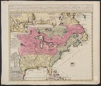
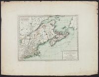
Includes inset of "Les costes de la Louisiane ....", Relief shown pictorially., and Yale's copy annotated in pencil with "circa 1760" on recto and "ca. 1720" on verso.
Publisher:
s.n.?,
Subject (Geographic):
New France--Maps--Early works to 1800 and North America--Maps--Early works to 1800
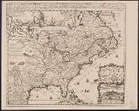
Appears in Chatelain's Atlas historique according to McCorkle., Cross collection no. 149., In upper right: Tom: VI. No: 23. Pag: 91., Includes notes, table of coordinates for certain locations, and ill., and Insets: Les environs de Quebec -- Veüe de Quebec -- Les costes de la Louisiane.
Publisher:
Chez L'Honoré & Châtelain Libraires?,
Subject (Geographic):
New France--Maps--Early works to 1800 and North America--Maps--Early works to 1800
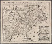
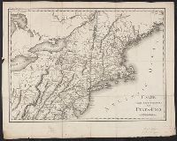
Appears in Chatelain's Atlas historique according to McCorkle., Cross collection no. 149., In upper right: Tom: VI. No: 23. Pag: 91., Includes notes, table of coordinates for certain locations, and ill., McCorkle attributes authorshi, and Relief shown pictorially.
Publisher:
Chez L'Honoré & Châtelain Libraires?,
Subject (Geographic):
New France--Maps--Early works to 1800 and North America--Maps--Early works to 1800
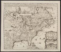
Appears in Chatelain's Atlas historique according to McC, In upper right: Tom: VI. No: 23. Pag: 91., Includes notes, table of coordinates for certain locations, and ill., McCorkle attributes authorship of this map to Nicolas de Fer., and Relief shown pictorially.
Publisher:
Chez L'Honoré & Châtelain Libraires?,
Subject (Geographic):
New France--Maps--Early works to 1800 and North America--Maps--Early works to 1800