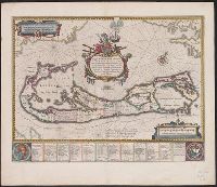
Mappa Aestivarvm insularum, alias Barmvdas dictarum
Description:
Based on Speed's map of 1626 but with new decorations., Below map, list of proprietors in 12 columns with arms of England and Bermuda., From the author's Theatre du monde ou nouvel atlas., Latin and English text on recto and French text on verso., Signature on verso: G., and Title on verso: L'Isle de Barmudas, avec ses voysines.
Publisher:
[Guillaume et Iean Blaeu,
Subject (Geographic):
Bermuda Islands--Maps--Early works to 1800
Subject (Name):
Blaeu, Joan, 1596-1673. Theatrum orbis terrarum. French and Blaeu, Willem Janszoon, 1571-1638. Theatrum orbis terrarum. French
Carte nouvelle contenant la partie d'Amerique la plus septentrionale : ou sont exactement dêcrites les provinces suivantes comme le Canada ou Nouvelle France, la Nouvelle Ecosse, la Nouvelle Angleterre, les Nouveaux Paı̈s Bas, la Pensylvanie, la Virginie
Description:
"Cum privilegio ordinum generalium foederati Belgii.", Appears in some eds. of the author's Atlas minor sive geographia compendiosa., Library copy incomplete, Atlantic Canada sheet only; damaged in upper left., and Relief shown pictorially. Depths shown by sound
Publisher:
Nicolao Visscher,
Subject (Geographic):
Atlantic Provinces--Maps--Early works to 1800 and North America--Maps--Early works to 1800
Subject (Name):
Anse, Luggert van, fl. 1690-1716, engraver and Visscher, Nicolaes, 1649-1702. Atlas minor sive geographia compendiosa
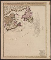
Descriptio ac delineatio geographica detectionis freti, sive, transitus ad occasum supra terras
Image Count:
1
Abstract:
Map depicts the Coat of Arms of the United Kingdom (era of the Union of the Crowns), reigning between the years 1603-1707.
Alternative Title:
Tabula nautica, qua repraesentantur orae maritimae, meatus, ac freta, noviter a H. Hudsono Anglo ad Caurum supra Novam Franciam
Description:
Bound in after p. [2]., In pencil on recto: 170., Map cut and folded irregularly., Map has multiple small stains on both the recto and verso., and Scale [ca. 1:9,000,000].
Descriptio ac delineatio geographica detectionis freti, sive, transitus ad occasum supra terras
Image Count:
1
Abstract:
Map depicts the Coat of Arms of the United Kingdom (era of the Union of the Crowns), reigning between the years 1603-1707.
Alternative Title:
Tabula nautica ...
Description:
Bound in after p. [6]., In ink on recto: place names "Okkak", "Nain"[?] and one longer handwritten note on the bottom margin., Map cut and folded irregularly., Map has been repaired with multiple pieces of tape on verso., Map has multiple small stains on both the recto and verso., Printed on recto in lower right corner: A1., and Scale [ca. 1:9,000,000].
Subject (Geographic):
North Atlantic Ocean --Maps --Early works to 1800
Subject (Name):
Hudson, Henry, d. 1611
Collection Created:
Amsterodami Ex officina Hesse lij Gerardi. Anno 1613
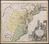
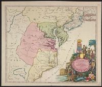
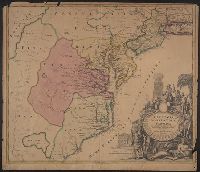
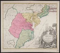
Also covers Delaware, southern Pennsylvania, New Jersey, western Long Island, southwestern Connecticut, and portions of adjacent areas., Bar scale given in "milliaria Germanica"., First appe, Includes ill., and Relief shown pictorially. Depths shown by soundings.
Also covers Delaware, southern Pennsylvania, New Jersey, western Long Island, southwestern Connecticut, and portions of adjacent areas., Bar scale given in "milliaria Germanica"., Includes ill., Relief shown pictorially. Depths shown by soundings., and Title in L
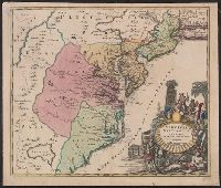
Also covers Delaware, southern Pennsylvania, New Jersey, western Long Island, southwestern Connecticut, and portions of adjacent areas., Bar scale given in "milliaria Germanica"., Includes ill., Prime meri, and Relief shown pictorially. Depths shown by soundings.
"Cum privilegio sac. caes. majest.", Also covers Delaware, southern P, Annotated "Quacker" near Philadelphia in red ink, and "100" in black ink on verso., Prime meridian: Ferro., Title in Latin. Place names in Latin, English, and French., and Watermark.