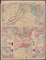
[Virginia, Maryland, Delaware] -- United States -- District of Columbia -- New Orleans, mouth of Mississippi -- Savannah -- Mobile Bay -- Galveston Bay -- Map of Mississippi River [2 maps] -- Cairo -- Pensacola Bay -- Norfolk Harbor -- Hampton Roads. and Reli
Publisher:
H.H. Lloyd : and Published under the auspices of the American Geographical and Statistical Society,
Subject (Geographic):
United States--Maps
Subject (Name):
American Geographical and Statistical Society, Haskins, Charles, and Viele, Egbert L. (Egbert Ludovicus), 1825-1902
At top of map: The rebellion as it was, Indicates towns, railroads, rivers, names and boundaries of states, and relief by hachures., and Shows "territory held by Rebels June 1st, 1864, in red," "territory gained from Rebels since January 1st, 1862, in yellow."
Publisher:
H.H. Lloyd & Co.,
Subject (Geographic):
United States--History--Civil War, 1861-1865--Maps
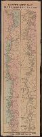
"N.B. This is the only map used to plan campaigns in Virginia by Cen. [sic] Scott.", Includes advertisements, tables of population, steamboat routes, and altitudes, and notes on mapping and geology., Prime meridian: Washington., and Relief shown by hachures.
Publisher:
J.T. Lloyd,
Subject (Geographic):
Virginia--History--Civil War, 1861-1865--Maps and Virginia--Maps
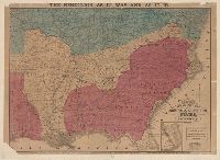
Differs from other 1862 edition in including a list of new maps to the right of the map title as well as "Deviation of the magnetic needle . . ." and "Memoranda" describing the sources and projection used to make the map, and lacking the warning to the ri
Differs from other 1862 edition in including a list of new maps to the right of the map title as well as "Deviation of the magnetic needle . . ." and "Memoranda" describing the sources and projection used to make the map, and lacking the warning to the ri
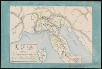
Coordinates not present on map and are approximated., Inscription below neat line "Reviglio Gius.", Manuscript number in lower right corner: 150., Relief shown by hachures., and Watermark.