"Avec privilege Janvier 1708.", "The words 'premier geographe du Roi' added in the title ... [indicate] that [a map] could not have been issued before 1718 when [De l'Isle] was appointed to that office"--Tooley, R.V. Guide to maps, and Relief shown pictorially.
Publisher:
chez l'auteur sur le Quai de l'Horloge,
Subject (Geographic):
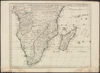
Africa, Central--Maps--Early works to 1800 and Africa, Southern--Maps--Early works to 1800
Appears in L'Isle's Atlas de géographie. Paris : Guillaume DeLisle, Quai de l'Horloge, 1731., Or, Relief shown pictorially., Sheet measures 54.9 x 74.6 cm., and Shows routes of Magellan, Sarmiento, Brower, Beauchesne, Sharp, Sr. de la Roche, Halley and Vespucci.
Publisher:
Chez l'auteur sur le Quai de l'Horloge ...,
Subject (Geographic):
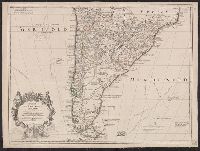
South America--Maps--1708-1718 and South America--Maps--Early works to 1800
Subject (Name):
Liebaux, engraver, L'Isle, Guillaume de, 1675-1726. Atlas de géographie, and Simonneau, Charles, 1645-1728
Appears in L'Isle's Atlas de géographie. Paris : Guillaume DeLisle, Quai de l'Horloge, 1731., Imprint of Louis Renard Libraire, Mounted in linen. Sheet measures 51.8 x 69.7 cm., Ornamental cartouche by "C. Simonneau inv. et fecit.", and Relief shown pictorially.
Publisher:
Chez l'auteur sur le Quai de l'Horloge ...,
Subject (Geographic):
South America--Maps--1708-1718 and South America--Maps--Early works to 1800
Subject (Name):
Liebaux, engraver, L'Isle, Guillaume de, 1675-1726. Atlas de géographie, and Simonneau, Charles, 1645-1728
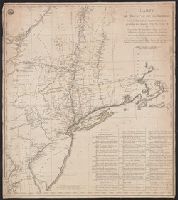
Includes "Renvois relatifs aux epoques des différentes opérations militaires.", Meridian: New York., On recto in upper left corner: stamp reading "Depot de la guerre"., On verso in upper right corner: "20-6 / No. 8" in ink., Relief shown pictorially., and Title
Publisher:
chez Fortin ingenieur méchanicien, and chez Perrier graveur :
Subject (Geographic):
Northeastern States--Maps--Early works to 1800, United States--History--Revolution, 1775-1783--Maps--Early works to 1800, and United States--Maps--Early works to 1800
Subject (Name):
Fortin, J. (Jean), 1740-1817? and Perrier, fl. 1760-1824
Although printed orientation indicates north at top of map, the layout of typography and place, Bar scale given in "Echelle de six milles 60 milles au degre"., Hand colored. Stamp: Karpinski-von Wieser Map Collection., and Relief shown pictorially.
Publisher:
Chez Melchoir Tavernier ...,
Subject (Geographic):
Valtellina (Italy)--Maps--Early works to 1800
Subject (Topic):
Thirty Years' War, 1618-1648--Campaigns--Italy--Valtellina--Maps
Has watermarks., Prime meridian: Ferro., and Relief shown pictorially.
Publisher:
[s.n.],
Subject (Geographic):
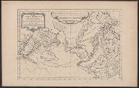
Arctic regions--Discovery and exploration--Maps--Early works to 1800, Arctic Regions--Maps--Early works to 1800, North Pacific Ocean--Maps--Early works to 1800, and Northwest Passage--Maps--Early works to 1800
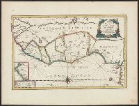
Annotated in black ink in top left margin: 23., Has watermark., Includes inset of coastal Senegal and ornamental cartouche., Relief shown pictorially., and Verso: stamped "Map Collection Yale Univ. Library".
Publisher:
Chez l'auteur sur le Quay de l'horloge, au coin de la rüe de Harlay,