Skip to search
Skip to main content
Skip to first result
Search
You Searched For
Genre
Aerial views
Resource Type
Maps, Atlases & Globes
New Search
Search Results
Creator:
Published / Created:
1935?]
Call Number:
831am 1935
Container / Volume:
BRBL_00581
Image Count:
2
Resource Type:
Maps, Atlases & Globes
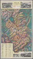
Alternative Title:
Glacier National Park aeroplane map
Description:
"M-40-35.", Includes ill., index, and distance table., Pictorial map., and Text and ill. on verso.
Publisher:
Great Northern,
Subject (Geographic):
Glacier National Park (Mont.)--Aerial views and Glacier National Park (Mont.)--Maps
Subject (Name):
McGill-Warner Co
Found in:
Beinecke Rare Book and Manuscript Library > Aeroplane map of Glacier National Park, Montana, with Logan Pass Detour.
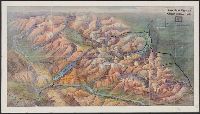
Creator:
Published / Created:
1914]
Call Number:
831am 1914
Container / Volume:
BRBL_00581
Image Count:
2
Resource Type:
Maps, Atlases & Globes
Alternative Title:
Glacier National Park
Description:
"5-27-1914 (100M).", Pictorial map., and Text and ill. on verso.
Publisher:
Great Northern Railway?,
Subject (Geographic):
Glacier National Park (Mont.)--Aerial views and Glacier National Park (Mont.)--Maps
Subject (Name):
McGill-Warner Co
Found in:
Beinecke Rare Book and Manuscript Library > Aeroplane view of Glacier National Park / Great Northern Railway.
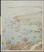
Creator:
Published / Created:
c1905.
Call Number:
764am B65 1905
Container / Volume:
BRBL_00460
Image Count:
1
Resource Type:
Maps, Atlases & Globes
Description:
Copyright: 1905 by the Federal Engraving and Publishing Co., Boston, Mass., Index to points of interest on cover., Oriented with north to the left., and Title from cover.
Publisher:
Published by John F. Murphy,
Subject (Geographic):
Boston Harbor (Mass.)--Maps, Boston Harbor Islands (Mass.)--Maps, Boston Harbor Region (Mass.)--Maps, and South Shore Region (Mass. : Coast)--Maps
Subject (Name):
Murphy, John F
Found in:
Beinecke Rare Book and Manuscript Library > Bird's eye view of Boston Harbor and South Shore to Provincetown : showing steamboat routes.
Published / Created:
[192-?]
Call Number:
899am 1910
Container / Volume:
BRBL_00660
Image Count:
2
Resource Type:
Maps, Atlases & Globes
Alternative Title:
Bird's eye view of the Panama Canal
Description:
"Copyright and published by I.L. Maduro's Souvenir Store"., Includes text, relief profile, and map of Panama., Relief shown pictorially., and Text and ill. on verso.
Publisher:
I.L. Maduro,
Subject (Geographic):
Panama Canal (Panama)--Aerial views
Found in:
Beinecke Rare Book and Manuscript Library > Bird's eye view of the Panama Canal & map of Panama.
Published / Created:
c1902.
Call Number:
762am M86 1902
Container / Volume:
BRBL_00451
Image Count:
1
Resource Type:
Maps, Atlases & Globes
Alternative Title:
Bird's eye view from Mt. Washington, New Hampshire
Description:
"Issued by Passenger Department of Boston & Maine R.R.", Includes key to 189 places., and Panel title: Bird's eye view from Mt. Washington, New Hampshire.
Publisher:
Geo. H. Walker & Co.,
Subject (Geographic):
Washington, Mount (N.H.)--Maps and White Mountains (N.H. and Me.)--Maps
Subject (Name):
Boston and Maine Railroad and Geo. H. Walker & Co
Found in:
Beinecke Rare Book and Manuscript Library > Birds-eye view from summit of Mt. Washington, White Mountains, New Hampshire.
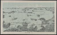
Creator:
Published / Created:
[1890?]
Call Number:
764am B65 1890A
Container / Volume:
BRBL_00460
Image Count:
1
Resource Type:
Maps, Atlases & Globes
Description:
Shows deatails of islands, bays, and buildings.
Publisher:
Walker Lith. & Pub. Co.,
Subject (Geographic):
Boston (Mass.)--Maps
Subject (Topic):
Harbors--Massachusetts--Boston--Aerial views
Found in:
Beinecke Rare Book and Manuscript Library > Boston Harbor.
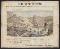
Creator:
Published / Created:
1855
Call Number:
35311hc 1855
Container / Volume:
BRBL_00112
Image Count:
1
Resource Type:
Maps, Atlases & Globes
Description:
Shows fortifications and troop positions.
Publisher:
E. Gambart & Co.,, Goupil & Ce. ;, and Verlag von Goupil & Co. ;
Subject (Geographic):
Crimea (Ukraine)--Aerial views
Subject (Topic):
Crimean War, 1853-1856--Aerial views
Found in:
Beinecke Rare Book and Manuscript Library > La Crimée a vol d'oiseau / desinée et lithographiée par Mm. Ph. Benoist et Eug. Cicéri d'apres les plans et dessins relevés par ordre des Gouvernements Anglais, Français et Russe ; imp. Lemercier, Paris.
Branch:v1.61.6 ,Deployed:2024-06-12T09:55:36-04:00